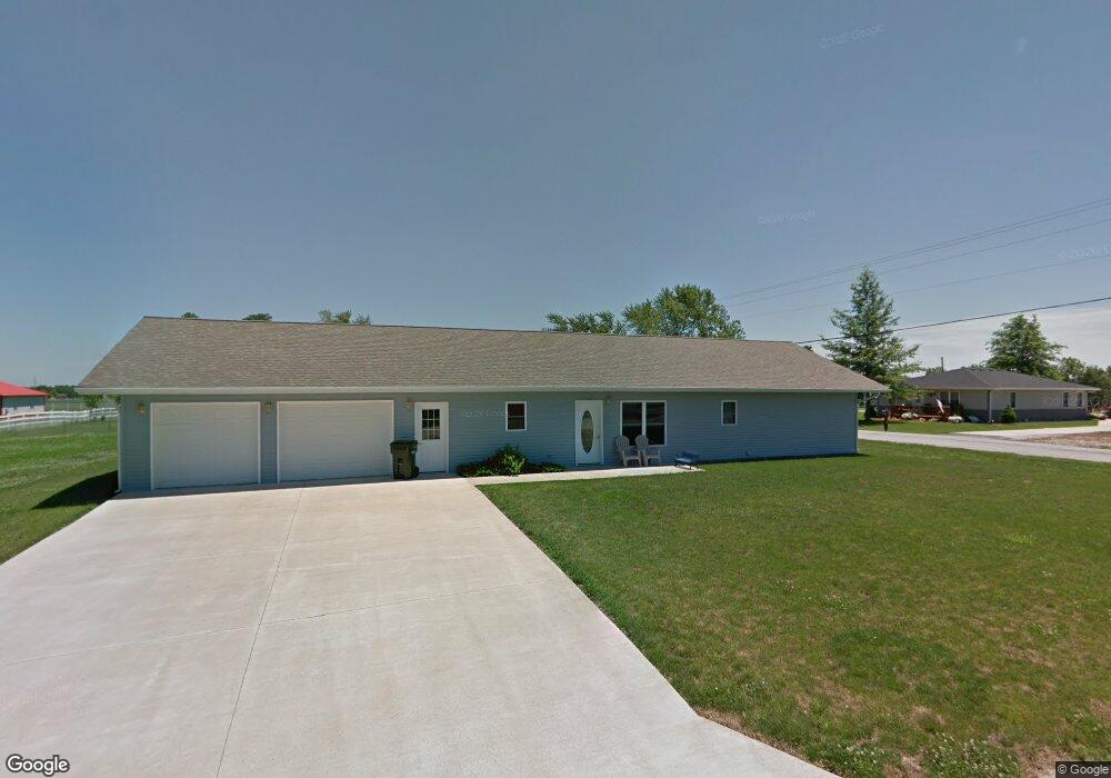
2907 Breezewood Dr Kirksville, MO 63501
Estimated Value: $239,000 - $301,000
2
Beds
2
Baths
1,568
Sq Ft
$173/Sq Ft
Est. Value
About This Home
This home is located at 2907 Breezewood Dr, Kirksville, MO 63501 and is currently estimated at $271,459, approximately $173 per square foot. 2907 Breezewood Dr is a home located in Adair County with nearby schools including Kirksville Primary School, Ray Miller Elementary School, and William Matthew Middle School.
Ownership History
Date
Name
Owned For
Owner Type
Purchase Details
Closed on
Sep 24, 2008
Sold by
Treasure Tyson Moore and Shafer Treasure Erin Marie
Bought by
Treasure Tyson Moore and Treasure Erin Marie
Current Estimated Value
Home Financials for this Owner
Home Financials are based on the most recent Mortgage that was taken out on this home.
Original Mortgage
$70,000
Outstanding Balance
$46,426
Interest Rate
6.46%
Mortgage Type
Purchase Money Mortgage
Estimated Equity
$225,033
Purchase Details
Closed on
Apr 7, 2008
Sold by
Jem Inc
Bought by
Treasure Tyson Moore and Shafer Erin Marie
Create a Home Valuation Report for This Property
The Home Valuation Report is an in-depth analysis detailing your home's value as well as a comparison with similar homes in the area
Home Values in the Area
Average Home Value in this Area
Purchase History
| Date | Buyer | Sale Price | Title Company |
|---|---|---|---|
| Treasure Tyson Moore | -- | Adair County Title & Escrow | |
| Treasure Tyson Moore | -- | Adair County Title & Escrow |
Source: Public Records
Mortgage History
| Date | Status | Borrower | Loan Amount |
|---|---|---|---|
| Open | Treasure Tyson Moore | $70,000 |
Source: Public Records
Tax History Compared to Growth
Tax History
| Year | Tax Paid | Tax Assessment Tax Assessment Total Assessment is a certain percentage of the fair market value that is determined by local assessors to be the total taxable value of land and additions on the property. | Land | Improvement |
|---|---|---|---|---|
| 2024 | $1,863 | $30,420 | $6,090 | $24,330 |
| 2023 | $1,855 | $29,600 | $6,090 | $23,510 |
| 2022 | $1,855 | $29,600 | $6,090 | $23,510 |
| 2021 | $1,832 | $29,600 | $6,090 | $23,510 |
| 2020 | $1,870 | $29,630 | $6,090 | $23,540 |
| 2019 | $1,801 | $30,420 | $6,090 | $24,330 |
| 2018 | $1,789 | $30,420 | $6,090 | $24,330 |
| 2017 | $1,181 | $20,150 | $3,900 | $16,250 |
| 2016 | -- | $20,150 | $3,900 | $16,250 |
| 2015 | -- | $20,150 | $3,900 | $16,250 |
| 2011 | -- | $0 | $0 | $0 |
Source: Public Records
Map
Nearby Homes
- 405 W Shepherd Ave
- 0 Meadow Ln
- 3308 S 1st St
- 405 Garrett Dr
- 23358 Rainbow Basin Trail
- 1921 S First St
- 1904 S 1st St
- 1902 S 1st St
- 3515 S 1st St
- 712 W Shelby St
- 203 W La Harpe St
- 23878 Youngstown Trail
- 2116 S Franklin St
- 2700 S Franklin St
- 801 W Hamilton St
- 702 W Hamilton St
- 1601 S Boundary St
- 306 Hillcrest Dr
- xxx Missouri 11
- 1104 W George St
- 2905 Breezewood Dr
- 1006 W Shepherd Ave
- 2906 Breezewood Dr
- 2904 Breezewood Dr
- 2903 Breezewood Dr
- 1004 W Shepherd Ave
- 1005 W Shepherd Ave
- 2902 Breezewood Dr
- . Breezewood Dr
- 2800 Breezewood Dr
- 2905 Weatherbrooke Dr
- 2907 Weatherbrooke Dr
- 2901 Breezewood Dr
- 2903 Weatherbrooke Dr
- 1003 W Shepherd Ave
- 2900 Breezewood Dr
- 3208 S Adams Dr
- 2901 Weatherbrooke Dr
- 1007 W Shepherd Ave
- 2809 Breezewood Dr