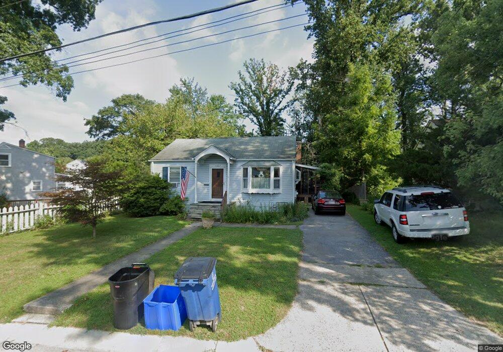
2907 Newton St Silver Spring, MD 20902
Estimated Value: $383,017 - $527,000
Studio
1
Bath
1,184
Sq Ft
$391/Sq Ft
Est. Value
About This Home
This home is located at 2907 Newton St, Silver Spring, MD 20902 and is currently estimated at $463,504, approximately $391 per square foot. 2907 Newton St is a home located in Montgomery County with nearby schools including Arcola Elementary School, Odessa Shannon Middle School, and Northwood High School.
Ownership History
Date
Name
Owned For
Owner Type
Purchase Details
Closed on
Aug 21, 2023
Sold by
Celtnieks Imants and Celtnieks Barbara M
Bought by
Celtnieks Family Trust and Celtnieks
Current Estimated Value
Purchase Details
Closed on
Nov 16, 2007
Sold by
Celtnieks Imants
Bought by
Celtnieks Imants Et Al Trustees
Purchase Details
Closed on
Nov 5, 2007
Sold by
Celtnieks Imants
Bought by
Celtnieks Imants Et Al Trustees
Create a Home Valuation Report for This Property
The Home Valuation Report is an in-depth analysis detailing your home's value as well as a comparison with similar homes in the area
Home Values in the Area
Average Home Value in this Area
Purchase History
| Date | Buyer | Sale Price | Title Company |
|---|---|---|---|
| Celtnieks Family Trust | -- | None Listed On Document | |
| Celtnieks Imants | -- | None Listed On Document | |
| Celtnieks Imants Et Al Trustees | -- | -- | |
| Celtnieks Imants Et Al Trustees | -- | -- |
Source: Public Records
Tax History
| Year | Tax Paid | Tax Assessment Tax Assessment Total Assessment is a certain percentage of the fair market value that is determined by local assessors to be the total taxable value of land and additions on the property. | Land | Improvement |
|---|---|---|---|---|
| 2025 | $4,991 | $390,200 | $180,200 | $210,000 |
| 2024 | $4,991 | $370,067 | $0 | $0 |
| 2023 | $4,043 | $349,933 | $0 | $0 |
| 2022 | $3,601 | $329,800 | $180,200 | $149,600 |
| 2021 | $3,213 | $316,800 | $0 | $0 |
| 2020 | $3,213 | $303,800 | $0 | $0 |
| 2019 | $3,035 | $290,800 | $165,400 | $125,400 |
| 2018 | $2,935 | $284,033 | $0 | $0 |
| 2017 | $2,904 | $277,267 | $0 | $0 |
| 2016 | -- | $270,500 | $0 | $0 |
| 2015 | $2,527 | $266,733 | $0 | $0 |
| 2014 | $2,527 | $262,967 | $0 | $0 |
Source: Public Records
Map
Nearby Homes
- 2715 Randolph Rd
- 12124 Livingston St
- 3405 Fredale St
- 12106 Bluhill Rd
- 12220 Centerhill St
- 2510 Weisman Rd
- 3410 Embry St
- 3027 Medway St
- 12816 Valleywood Dr
- 3007 Medway St
- 2511 Auden Dr
- 3409 Janet Rd
- 135 Klee Aly
- 2305 Greenery Ln Unit 1023
- 2202 Greenery Ln Unit 301
- 2200 Greenery Ln Unit 101
- 2301 Greenery Ln Unit 103
- 2373 Wyeth St
- 12420 Feldon St
- 12929 Valleywood Dr
- 2905 Newton St
- 3001 Lindell St
- 3003 Lindell St
- 2903 Newton St
- 3005 Lindell St
- 2907 Lindell St
- 2904 Randolph Rd
- 2902 Newton St
- 2901 Newton St
- 2902 Randolph Rd
- 3007 Lindell St
- 2900 Randolph Rd
- 12306 Kendall St
- 2905 Lindell St
- 3000 Lindell St
- 2918 Lindell St
- 3002 Lindell St
- 12304 Kendall St
- 0 Randolph Rd
- 2916 Lindell St
Your Personal Tour Guide
Ask me questions while you tour the home.