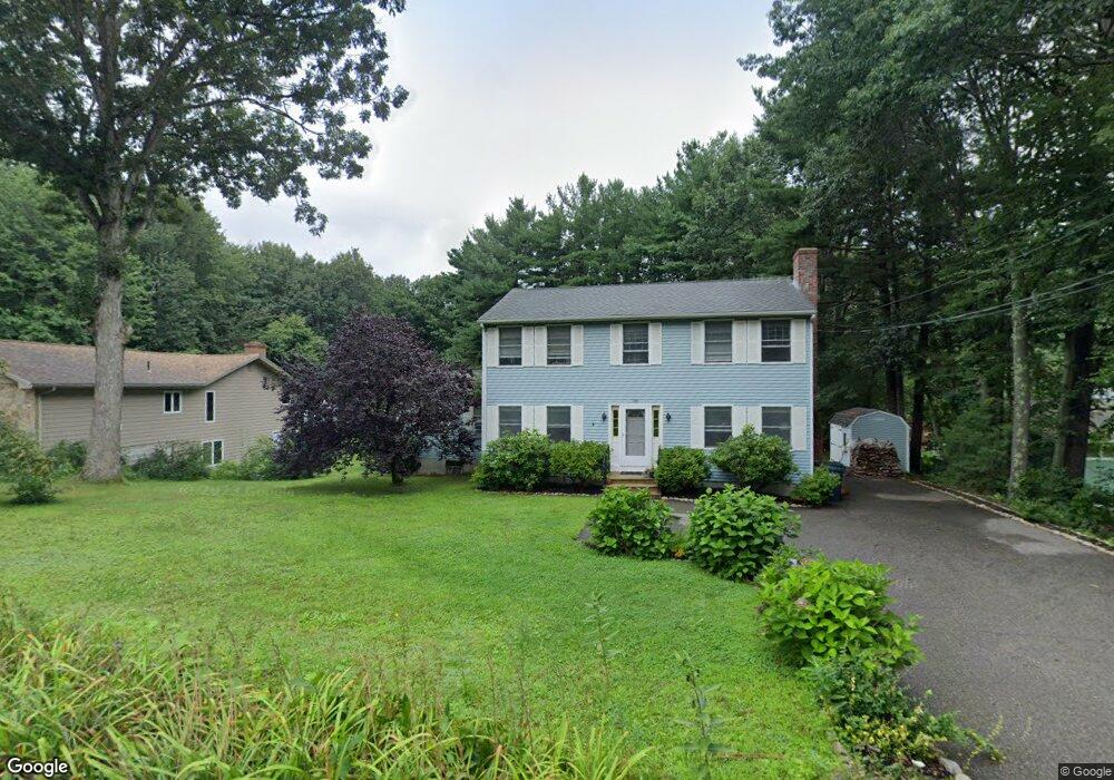
291 Bailey Rd Holden, MA 01520
Estimated Value: $569,000 - $630,000
3
Beds
2
Baths
2,137
Sq Ft
$277/Sq Ft
Est. Value
About This Home
This home is located at 291 Bailey Rd, Holden, MA 01520 and is currently estimated at $592,181, approximately $277 per square foot. 291 Bailey Rd is a home located in Worcester County with nearby schools including Wachusett Regional High School and Holden Christian Academy.
Ownership History
Date
Name
Owned For
Owner Type
Purchase Details
Closed on
Sep 23, 2023
Sold by
Odonnell Edward T and Odonnell Stephanie Y
Bought by
Edward T & S Odonnell Lt and Odonnell
Current Estimated Value
Purchase Details
Closed on
Jul 24, 2001
Sold by
Sherblom Bradford H and Sherblom Kathleen A
Bought by
Odonnell Edward T and Odonnell Stephanie Y
Purchase Details
Closed on
May 1, 1992
Sold by
Collard Darlene A and Granahan Constance
Bought by
Sherblom Bradford H and Sherblom Kathleen
Create a Home Valuation Report for This Property
The Home Valuation Report is an in-depth analysis detailing your home's value as well as a comparison with similar homes in the area
Home Values in the Area
Average Home Value in this Area
Purchase History
| Date | Buyer | Sale Price | Title Company |
|---|---|---|---|
| Edward T & S Odonnell Lt | -- | None Available | |
| Odonnell Edward T | $239,900 | -- | |
| Sherblom Bradford H | $78,600 | -- |
Source: Public Records
Mortgage History
| Date | Status | Borrower | Loan Amount |
|---|---|---|---|
| Previous Owner | Sherblom Bradford H | $307,332 | |
| Previous Owner | Sherblom Bradford H | $225,000 |
Source: Public Records
Tax History
| Year | Tax Paid | Tax Assessment Tax Assessment Total Assessment is a certain percentage of the fair market value that is determined by local assessors to be the total taxable value of land and additions on the property. | Land | Improvement |
|---|---|---|---|---|
| 2025 | $6,626 | $478,100 | $142,400 | $335,700 |
| 2024 | $6,202 | $438,300 | $138,300 | $300,000 |
| 2023 | $6,140 | $409,600 | $120,200 | $289,400 |
| 2022 | $5,821 | $351,500 | $93,800 | $257,700 |
| 2021 | $5,646 | $324,500 | $89,400 | $235,100 |
| 2020 | $5,484 | $322,600 | $85,200 | $237,400 |
| 2019 | $5,354 | $306,800 | $85,200 | $221,600 |
| 2018 | $5,161 | $293,100 | $81,000 | $212,100 |
| 2017 | $4,668 | $265,400 | $81,000 | $184,400 |
| 2016 | $4,328 | $250,900 | $77,100 | $173,800 |
| 2015 | $4,392 | $242,400 | $77,100 | $165,300 |
| 2014 | $4,303 | $242,400 | $77,100 | $165,300 |
Source: Public Records
Map
Nearby Homes
- 289 Bailey Rd
- 131 Twinbrooke Dr
- 168 Twinbrooke Dr
- 216 Reservoir St Unit 107
- 216 Reservoir St Unit 208
- 216 Reservoir St Unit 202
- 218 Reservoir St Unit 326
- 0 Chapin Rd
- 8 (Lot 1) Holmes Dr
- 527 Salisbury St
- 26 Avery Heights Dr
- 576 Reservoir St
- 47 Harvest Cir
- 23 Gail Dr
- 63 Walnut St
- 136 Winthrop Ln
- 135 Highland Ave
- 56 Highland Ave
- 81 Deanna Dr
- 134 Jamieson Rd
- 295 Bailey Rd
- 283 Bailey Rd
- 307 Bailey Rd
- 292 Bailey Rd
- 271 Bailey Rd
- 39 Stone Ridge - Country Hill Rd Unit 39
- 35 Princeton St Unit 1
- 19 Country Hill Rd Unit 19
- 23 Willow Brook Rd
- 280 Bailey Rd
- 310 Bailey Rd
- 33 Willow Brook Rd
- 325 Bailey Rd
- 20 Willow Brook Rd
- 328 Bailey Rd
- 41 Willow Brook Rd
- 245 Bailey Rd
- 333 Bailey Rd
- 24 Willow Brook Rd
- 334 Bailey Rd
Your Personal Tour Guide
Ask me questions while you tour the home.