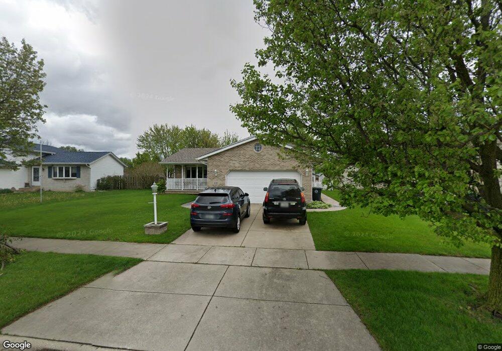
291 Mcafee Dr Hobart, IN 46342
Estimated Value: $307,173 - $337,000
4
Beds
3
Baths
1,992
Sq Ft
$164/Sq Ft
Est. Value
About This Home
This home is located at 291 Mcafee Dr, Hobart, IN 46342 and is currently estimated at $326,793, approximately $164 per square foot. 291 Mcafee Dr is a home located in Lake County with nearby schools including Hobart High School, Portage Christian School, and Hobart Baptist School.
Ownership History
Date
Name
Owned For
Owner Type
Purchase Details
Closed on
Jul 14, 2021
Sold by
Bird Susan C and Susan C Bird Revocable Living Trust
Bought by
Krooswyk Joel and Krooswyk Beth
Current Estimated Value
Home Financials for this Owner
Home Financials are based on the most recent Mortgage that was taken out on this home.
Original Mortgage
$200,700
Outstanding Balance
$181,709
Interest Rate
2.9%
Mortgage Type
New Conventional
Estimated Equity
$145,084
Purchase Details
Closed on
Jun 10, 2021
Sold by
Lesniewski Cynthia K and Lesniewski Carl
Bought by
Flickinger Jennifer and Torres Regnier Tylor
Home Financials for this Owner
Home Financials are based on the most recent Mortgage that was taken out on this home.
Original Mortgage
$200,700
Outstanding Balance
$181,709
Interest Rate
2.9%
Mortgage Type
New Conventional
Estimated Equity
$145,084
Purchase Details
Closed on
Feb 9, 2007
Sold by
Marcoff Carl and Marcoff Joanne
Bought by
Marcoff Carl and Marcoff Joanne
Create a Home Valuation Report for This Property
The Home Valuation Report is an in-depth analysis detailing your home's value as well as a comparison with similar homes in the area
Home Values in the Area
Average Home Value in this Area
Purchase History
| Date | Buyer | Sale Price | Title Company |
|---|---|---|---|
| Krooswyk Joel | -- | Community Title | |
| Flickinger Jennifer | $223,000 | Community Title Co | |
| Marcoff Carl | -- | None Available |
Source: Public Records
Mortgage History
| Date | Status | Borrower | Loan Amount |
|---|---|---|---|
| Open | Flickinger Jennifer | $200,700 |
Source: Public Records
Tax History Compared to Growth
Tax History
| Year | Tax Paid | Tax Assessment Tax Assessment Total Assessment is a certain percentage of the fair market value that is determined by local assessors to be the total taxable value of land and additions on the property. | Land | Improvement |
|---|---|---|---|---|
| 2024 | $10,549 | $264,100 | $40,100 | $224,000 |
| 2023 | $3,095 | $258,400 | $40,100 | $218,300 |
| 2022 | $2,882 | $237,600 | $40,100 | $197,500 |
| 2021 | $2,630 | $215,300 | $33,600 | $181,700 |
| 2020 | $2,452 | $210,800 | $33,600 | $177,200 |
| 2019 | $2,518 | $201,200 | $33,600 | $167,600 |
| 2018 | $2,355 | $192,600 | $33,600 | $159,000 |
| 2017 | $2,279 | $188,100 | $33,600 | $154,500 |
| 2016 | $2,099 | $185,600 | $33,600 | $152,000 |
| 2014 | $1,956 | $184,600 | $33,600 | $151,000 |
| 2013 | $1,750 | $174,200 | $33,600 | $140,600 |
Source: Public Records
Map
Nearby Homes
- 3778 Helix St Unit 171
- 5075 Wessex St Unit 182
- 5096 Wessex St Unit 158
- 2913 Drexel Dr
- 5108 Burnham Ave Unit 249
- 524 Camelot Manor Unit 524
- 5136 Canterbury Ave Unit 234
- 850 Camelot Manor Unit 850
- 714 Camelot Manor Unit 714
- 5156 Exeter Ave Unit 285
- 411 N Union St
- 199 N Union St
- 5217 Westchester Ave Unit 110
- 5242 Westchester Ave Unit 117
- 2080 E Rand St
- 240 Rush Ct
- 1891 Cooke St
- 315 N Hobart Rd
- 3321 Morningside St
- 5062 Boulder Ave