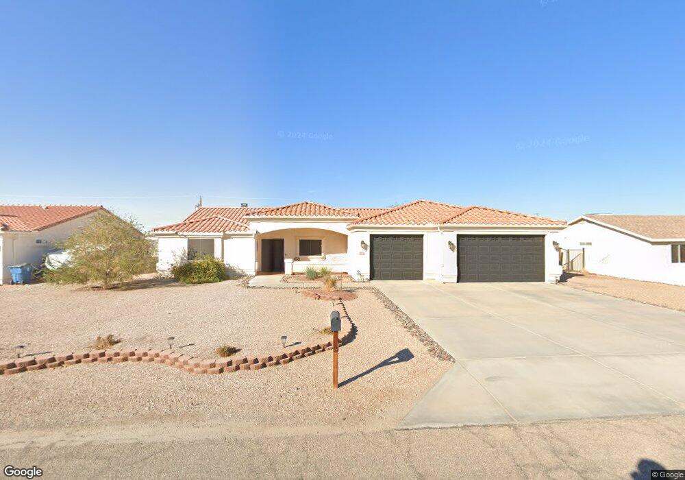
291 Opossum Dr Lake Havasu City, AZ 86404
Estimated Value: $594,911 - $741,000
--
Bed
--
Bath
1,728
Sq Ft
$384/Sq Ft
Est. Value
About This Home
This home is located at 291 Opossum Dr, Lake Havasu City, AZ 86404 and is currently estimated at $663,728, approximately $384 per square foot. 291 Opossum Dr is a home located in Mohave County with nearby schools including Jamaica Elementary School, Thunderbolt Middle School, and Lake Havasu High School.
Ownership History
Date
Name
Owned For
Owner Type
Purchase Details
Closed on
Jan 16, 2020
Sold by
Oliva Melissa A
Bought by
Brown Roger L and Oliva Melissa A
Current Estimated Value
Purchase Details
Closed on
Sep 27, 2004
Sold by
Oliva Philip R and Oliva Melissa A
Bought by
Hock Edward C and Hock Melissa Ann
Home Financials for this Owner
Home Financials are based on the most recent Mortgage that was taken out on this home.
Original Mortgage
$152,000
Interest Rate
5.75%
Mortgage Type
Construction
Create a Home Valuation Report for This Property
The Home Valuation Report is an in-depth analysis detailing your home's value as well as a comparison with similar homes in the area
Home Values in the Area
Average Home Value in this Area
Purchase History
| Date | Buyer | Sale Price | Title Company |
|---|---|---|---|
| Brown Roger L | -- | Pioneer Title Agency Inc | |
| Hock Edward C | -- | Chicago Title Insurance Co |
Source: Public Records
Mortgage History
| Date | Status | Borrower | Loan Amount |
|---|---|---|---|
| Previous Owner | Hock Edward C | $152,000 |
Source: Public Records
Tax History Compared to Growth
Tax History
| Year | Tax Paid | Tax Assessment Tax Assessment Total Assessment is a certain percentage of the fair market value that is determined by local assessors to be the total taxable value of land and additions on the property. | Land | Improvement |
|---|---|---|---|---|
| 2026 | $1,145 | -- | -- | -- |
| 2025 | $2,321 | $54,871 | $0 | $0 |
| 2024 | $2,321 | $55,517 | $0 | $0 |
| 2023 | $2,321 | $48,353 | $0 | $0 |
| 2022 | $2,221 | $32,014 | $0 | $0 |
| 2021 | $2,406 | $27,344 | $0 | $0 |
| 2019 | $2,283 | $24,603 | $0 | $0 |
| 2018 | $2,205 | $23,580 | $0 | $0 |
| 2017 | $2,183 | $23,151 | $0 | $0 |
| 2016 | $1,973 | $22,575 | $0 | $0 |
| 2015 | $1,889 | $19,344 | $0 | $0 |
Source: Public Records
Map
Nearby Homes
- 340 Opossum Dr
- 3525 Kiowa Blvd S
- 3550 Tecumseh Dr
- 3646 Yazoo Ln
- 3851 Texoma Dr
- 3861 Texoma Dr
- 3780 Hiawatha Dr
- 3776 Hiawatha Dr
- 250 Geronimo Blvd
- 3501 Amberwood Place
- 3410 Kiowa Blvd S
- 3610 Pontchartrain Dr
- 3461 Antelope Dr
- 3691 Yazoo Dr
- 3493 Mitchell Ln
- 3811 Canyon Cove Dr
- 3446 S Amberwood Bay
- 3504 Pioneer Dr
- 3840 Canyon Cove Dr
- 3850 Canyon Cove Dr
- 281 Opossum Dr
- 301 Opossum Dr
- 3670 Texoma Dr
- 3680 Texoma Dr
- 3660 Texoma Dr
- 271 Opossum Dr
- 271 Opossum Dr
- 290 Opossum Dr
- 0 Opossum Dr - 311 Unit 7757827-11600590
- 313 Opossum Dr
- 3650 Texoma Dr
- 3650 Texoma Dr
- 261 Opossum Dr
- 261 Opossum Dr
- 298 Opossum Place
- 292 Opossum Place
- 280 Opossum Dr
- 3720 Texoma
- 3661 Texoma Dr
- 3640 Texoma Dr