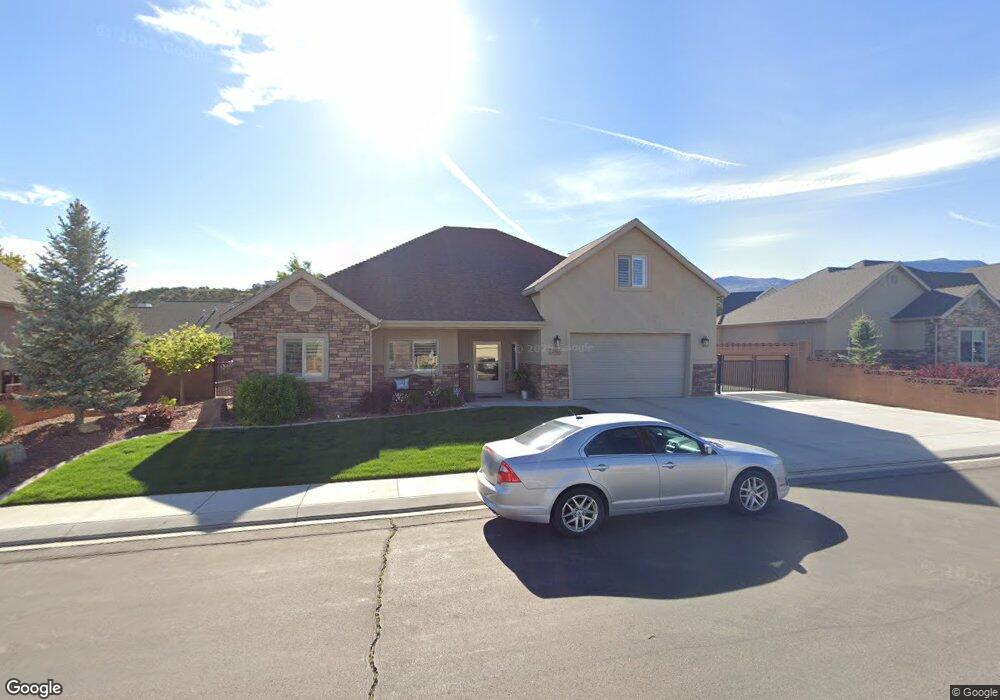
291 S 2875 W Cedar City, UT 84720
Estimated Value: $435,000 - $655,000
--
Bed
--
Bath
--
Sq Ft
8,015
Sq Ft Lot
About This Home
This home is located at 291 S 2875 W, Cedar City, UT 84720 and is currently estimated at $523,482. 291 S 2875 W is a home with nearby schools including Iron Springs School, Cedar Middle School, and Cedar City High School.
Ownership History
Date
Name
Owned For
Owner Type
Purchase Details
Closed on
Feb 16, 2021
Sold by
Black John R and Black Sonja
Bought by
Black John R and Black Sonja S
Current Estimated Value
Home Financials for this Owner
Home Financials are based on the most recent Mortgage that was taken out on this home.
Original Mortgage
$184,700
Outstanding Balance
$165,051
Interest Rate
2.65%
Mortgage Type
New Conventional
Estimated Equity
$358,431
Purchase Details
Closed on
Nov 14, 2016
Sold by
Black John and Black Sonja
Bought by
Black John R and Black Sonja S
Home Financials for this Owner
Home Financials are based on the most recent Mortgage that was taken out on this home.
Original Mortgage
$195,415
Interest Rate
3.42%
Mortgage Type
New Conventional
Create a Home Valuation Report for This Property
The Home Valuation Report is an in-depth analysis detailing your home's value as well as a comparison with similar homes in the area
Home Values in the Area
Average Home Value in this Area
Purchase History
| Date | Buyer | Sale Price | Title Company |
|---|---|---|---|
| Black John R | -- | Accommodation | |
| Black John R | -- | Mountain View Ttl Cedar City | |
| Black John R | -- | Cedar Land Title Inc | |
| Black John | -- | Cedar Land Title Inc |
Source: Public Records
Mortgage History
| Date | Status | Borrower | Loan Amount |
|---|---|---|---|
| Open | Black John R | $184,700 | |
| Closed | Black John | $195,415 |
Source: Public Records
Tax History Compared to Growth
Tax History
| Year | Tax Paid | Tax Assessment Tax Assessment Total Assessment is a certain percentage of the fair market value that is determined by local assessors to be the total taxable value of land and additions on the property. | Land | Improvement |
|---|---|---|---|---|
| 2025 | $2,082 | $267,664 | $36,261 | $231,403 |
| 2023 | $2,529 | $213,470 | $36,260 | $177,210 |
| 2022 | $1,962 | $213,470 | $36,260 | $177,210 |
| 2021 | $1,506 | $163,840 | $15,905 | $147,935 |
| 2020 | $1,563 | $150,780 | $15,905 | $134,875 |
| 2019 | $1,592 | $146,890 | $15,905 | $130,985 |
| 2018 | $1,622 | $144,795 | $15,905 | $128,890 |
| 2017 | $1,497 | $131,570 | $14,080 | $117,490 |
| 2016 | $329 | $26,940 | $26,940 | $0 |
| 2015 | -- | $0 | $0 | $0 |
Source: Public Records
Map
Nearby Homes
- 291 S Marble Canyon Cir
- 2846 W 350 S
- 360 S Cross Hollow Rd
- 2707 W Cookie Jar Cir
- 2691 W 225 S (Cookie Jar Cir)
- 2944 W Ezra Dr
- 2953 W Ezra Dr
- 52 S House Rock Dr
- 2957 Lagrand St Unit 1193
- 2958 Lagrand St Unit 1159
- 2996 Lagrand St Unit 1167
- 2992 Lagrand St Unit 1166
- 2988 Lagrand St Unit 1164
- Millbrook Plan at Old Sorrel Ranch - Old Sorrel Townhomes
- Dalton Plan at Old Sorrel Ranch - Old Sorrel Townhomes
- Oakridge Plan at Old Sorrel Ranch - Old Sorrel Townhomes
- 46 S Glen Canyon Dr
- 46.39 Acre Cross Hollow(n Side Is Cody
- 387 S Carmel Ridge Cir
- 307 S 2875 W
- 277 S 2875 W
- 290 S Marble Canyon Cir
- 278 S Marble Canyon Cir
- 308 S 2875 W
- 278 S 2875 W
- 321 S 2875 W
- 263 S 2875 W
- 301 S Marble Canyon Cir
- 264 S 2875 W
- 322 S 2875 W
- 335 S 2875 W
- 279 S Marble Canyon Cir
- 291 S Marble Canyon Cir Unit 1
- 265 S Marble Canyon Cir
- 336 S 2875 W
- 2821 W 250 S
- 245 S 2875 W
- 288 S House Rock Cir
- 246 S 2875 W