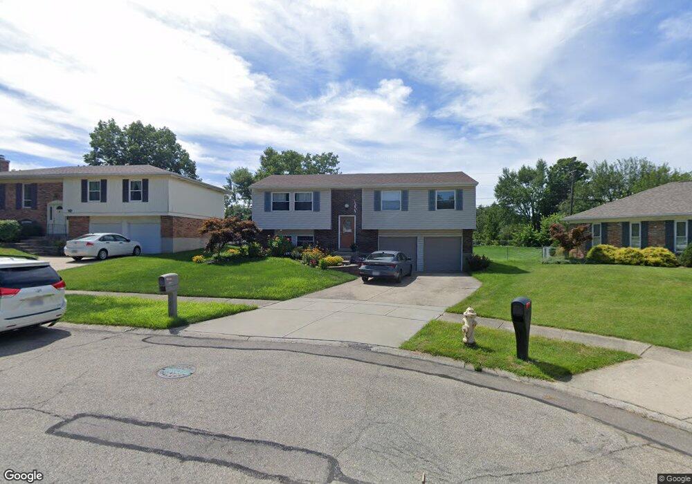
291 Sebastian Ct Cincinnati, OH 45238
Delhi Hills NeighborhoodEstimated Value: $239,000 - $284,000
3
Beds
2
Baths
1,686
Sq Ft
$154/Sq Ft
Est. Value
About This Home
This home is located at 291 Sebastian Ct, Cincinnati, OH 45238 and is currently estimated at $259,048, approximately $153 per square foot. 291 Sebastian Ct is a home located in Hamilton County with nearby schools including C.O. Harrison Elementary School, Delhi Middle School, and Oak Hills High School.
Ownership History
Date
Name
Owned For
Owner Type
Purchase Details
Closed on
Oct 2, 2023
Sold by
Burns Daniel W
Bought by
Burns Daniel W and Burns Julie A
Current Estimated Value
Purchase Details
Closed on
Jun 28, 2002
Sold by
Ball Terry G and Ball Michelle M
Bought by
Burns Daneil W
Home Financials for this Owner
Home Financials are based on the most recent Mortgage that was taken out on this home.
Original Mortgage
$131,929
Interest Rate
6.79%
Mortgage Type
FHA
Create a Home Valuation Report for This Property
The Home Valuation Report is an in-depth analysis detailing your home's value as well as a comparison with similar homes in the area
Home Values in the Area
Average Home Value in this Area
Purchase History
| Date | Buyer | Sale Price | Title Company |
|---|---|---|---|
| Burns Daniel W | -- | None Listed On Document | |
| Burns Daneil W | $134,000 | Ati Title Agency Of Ohio Inc |
Source: Public Records
Mortgage History
| Date | Status | Borrower | Loan Amount |
|---|---|---|---|
| Previous Owner | Burns Daneil W | $131,929 |
Source: Public Records
Tax History Compared to Growth
Tax History
| Year | Tax Paid | Tax Assessment Tax Assessment Total Assessment is a certain percentage of the fair market value that is determined by local assessors to be the total taxable value of land and additions on the property. | Land | Improvement |
|---|---|---|---|---|
| 2024 | $4,107 | $70,809 | $11,270 | $59,539 |
| 2023 | $4,120 | $70,809 | $11,270 | $59,539 |
| 2022 | $2,930 | $44,741 | $9,821 | $34,920 |
| 2021 | $2,870 | $44,741 | $9,821 | $34,920 |
| 2020 | $2,903 | $44,741 | $9,821 | $34,920 |
| 2019 | $2,647 | $36,673 | $8,050 | $28,623 |
| 2018 | $2,650 | $36,673 | $8,050 | $28,623 |
| 2017 | $2,392 | $36,673 | $8,050 | $28,623 |
| 2016 | $2,576 | $39,558 | $8,481 | $31,077 |
| 2015 | $2,579 | $39,558 | $8,481 | $31,077 |
| 2014 | $2,582 | $39,558 | $8,481 | $31,077 |
| 2013 | $2,557 | $41,636 | $8,925 | $32,711 |
Source: Public Records
Map
Nearby Homes
- 276 Centerview Dr
- 5027 Giles Ct
- 5084 Francisvalley Ct
- 5059 Grosse Pointe Ln
- 263 Clareknoll Ct
- 4998 Mt Alverno Rd
- 309 Greenwell Ave
- 372 Marbill Ln
- 290 Shaker Ct
- 181 Palisades Point
- 4946 Riverwatch Dr
- 5140 Old Oak Trail Unit 34
- 4904 Riverwatch Dr
- 407 Elm St
- 307 Pedretti Ave
- 464 Happy Dr
- 5468 Courier Ct
- 3938 Hillside Ave
- 4996 Donlar Ave
- 548 Anderson Ferry Rd
- 287 Sebastian Ct
- 295 Sebastian Ct
- 5118 Orangelawn Dr
- 5124 Orangelawn Dr
- 283 Sebastian Ct
- 5110 Orangelawn Dr
- 296 Sebastian Ct
- 5104 Orangelawn Dr
- 279 Sebastian Ct
- 5132 Orangelawn Dr
- 288 Sebastian Ct
- 5095 Chantilly Dr
- 284 Sebastian Ct
- 5089 Chantilly Dr
- 5101 Chantilly Dr
- 292 Sebastian Ct
- 5096 Orangelawn Dr
- 5085 Chantilly Dr
- 5105 Chantilly Dr
- 280 Sebastian Ct