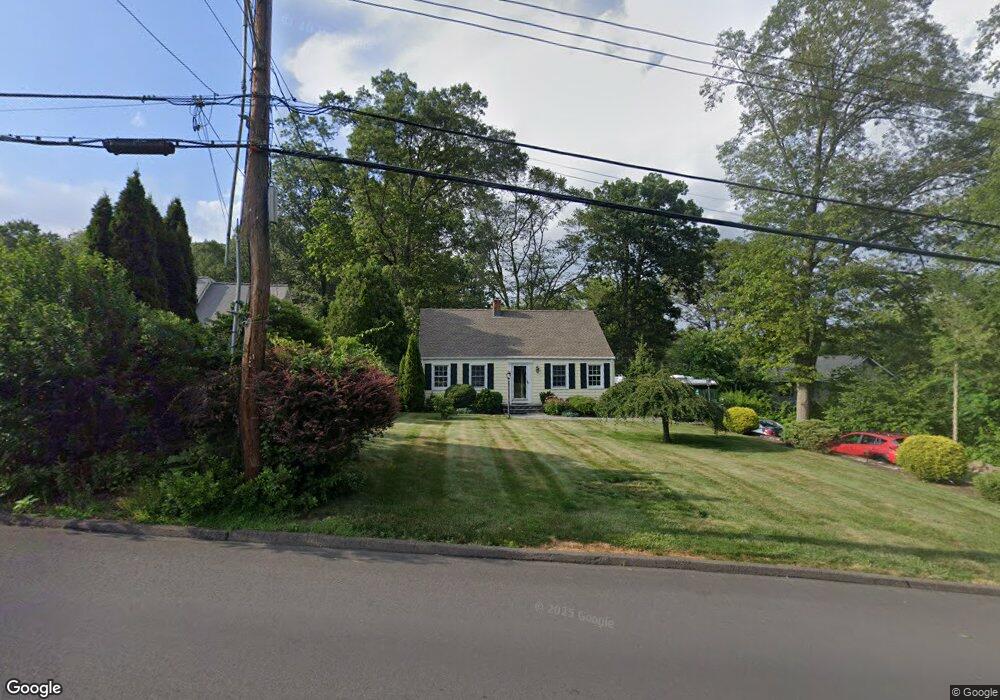
291 W Shepard Ave Hamden, CT 06514
Estimated Value: $356,196 - $427,000
3
Beds
2
Baths
1,296
Sq Ft
$297/Sq Ft
Est. Value
About This Home
This home is located at 291 W Shepard Ave, Hamden, CT 06514 and is currently estimated at $385,549, approximately $297 per square foot. 291 W Shepard Ave is a home located in New Haven County with nearby schools including Hamden Middle School, Hamden High School, and Laurel Oaks Adventist School.
Ownership History
Date
Name
Owned For
Owner Type
Purchase Details
Closed on
Jul 26, 2000
Sold by
Biggs Michael R and Biggs Susan
Bought by
Massarelli Michael F and Houston Brian F
Current Estimated Value
Home Financials for this Owner
Home Financials are based on the most recent Mortgage that was taken out on this home.
Original Mortgage
$120,000
Interest Rate
8.18%
Purchase Details
Closed on
Nov 3, 1999
Sold by
Nerreau Irene O
Bought by
Biggs Michael R
Create a Home Valuation Report for This Property
The Home Valuation Report is an in-depth analysis detailing your home's value as well as a comparison with similar homes in the area
Home Values in the Area
Average Home Value in this Area
Purchase History
| Date | Buyer | Sale Price | Title Company |
|---|---|---|---|
| Massarelli Michael F | $152,000 | -- | |
| Biggs Michael R | $150,000 | -- |
Source: Public Records
Mortgage History
| Date | Status | Borrower | Loan Amount |
|---|---|---|---|
| Open | Biggs Michael R | $200,500 | |
| Closed | Biggs Michael R | $204,000 | |
| Closed | Biggs Michael R | $44,700 | |
| Closed | Biggs Michael R | $120,000 |
Source: Public Records
Tax History Compared to Growth
Tax History
| Year | Tax Paid | Tax Assessment Tax Assessment Total Assessment is a certain percentage of the fair market value that is determined by local assessors to be the total taxable value of land and additions on the property. | Land | Improvement |
|---|---|---|---|---|
| 2024 | $7,388 | $132,860 | $45,500 | $87,360 |
| 2023 | $7,491 | $132,860 | $45,500 | $87,360 |
| 2022 | $7,371 | $132,860 | $45,500 | $87,360 |
| 2021 | $6,967 | $132,860 | $45,500 | $87,360 |
| 2020 | $7,266 | $139,790 | $79,310 | $60,480 |
| 2019 | $6,830 | $139,790 | $79,310 | $60,480 |
| 2018 | $6,704 | $139,790 | $79,310 | $60,480 |
| 2017 | $6,327 | $139,790 | $79,310 | $60,480 |
| 2016 | $6,341 | $139,790 | $79,310 | $60,480 |
| 2015 | $6,251 | $152,950 | $88,130 | $64,820 |
| 2014 | $6,107 | $152,950 | $88,130 | $64,820 |
Source: Public Records
Map
Nearby Homes
- 44 Laura Rd
- 51 Laura Rd
- 89 Bear Path Rd
- 1180 Shepard Ave
- 141 Old Coach Hwy
- 1145 Sherman Ave
- 112 Sky View Cir
- 68 Nutmeg Hill Rd
- 1378 Shepard Ave
- 225 Hill St
- 23 Hunters Way
- 785 Paradise Ave
- 35 Sherman Ln Unit C4
- 16 Gate Way
- 46 Ash Dr
- 1399 Shepard Ave
- 3 Valley View Dr Unit 3
- 52 Quarry Ln
- 435 Shepard Ave
- 17 Valley View Ct Unit 31
- 285 W Shepard Ave
- 299 W Shepard Ave
- 1340 Paradise Ave
- 309 W Shepard Ave
- 315 W Shepard Ave
- 1330 Paradise Ave
- 1370 Paradise Ave
- 321 W Shepard Ave
- 275 W Shepard Ave
- 1335 Paradise Ave
- 1355 Paradise Ave
- 296 W Shepard Ave
- 286 W Shepard Ave
- 325 W Shepard Ave
- 1380 Paradise Ave
- 255 W Shepard Ave
- 1345 Paradise Ave
- 331 W Shepard Ave
- 1375 Paradise Ave
- 328 W Shepard Ave