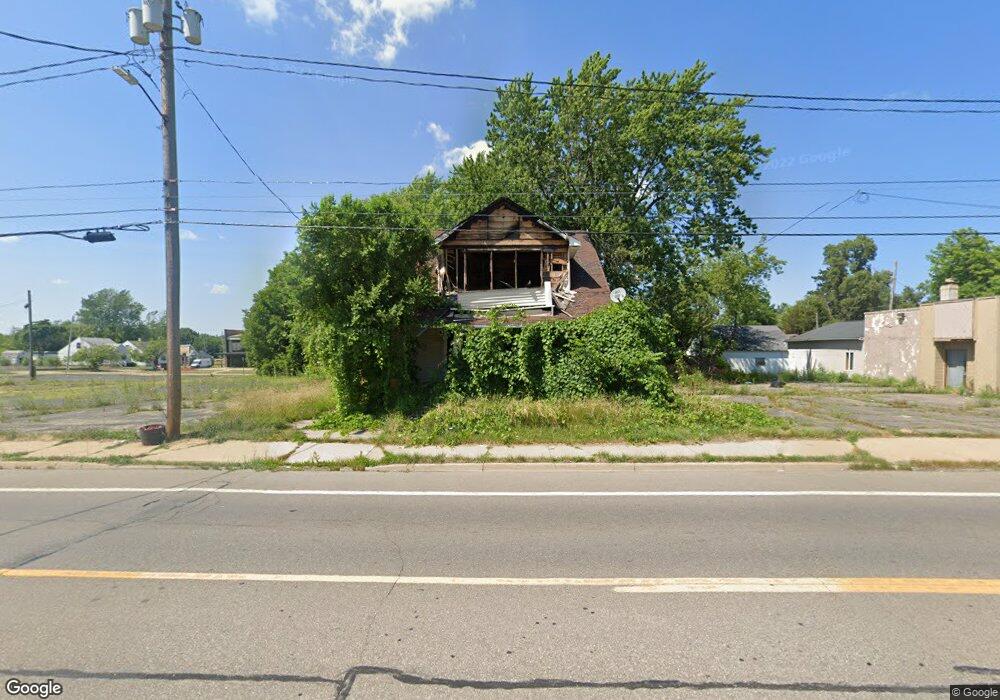
2910 Corunna Rd Flint, MI 48503
Mannhall Park NeighborhoodEstimated Value: $52,000 - $65,680
3
Beds
2
Baths
1,532
Sq Ft
$40/Sq Ft
Est. Value
About This Home
This home is located at 2910 Corunna Rd, Flint, MI 48503 and is currently estimated at $60,560, approximately $39 per square foot. 2910 Corunna Rd is a home located in Genesee County with nearby schools including Durant-Tuuri-Mott Elementary School, St. Paul Lutheran School, and St John Vianney Catholic School.
Ownership History
Date
Name
Owned For
Owner Type
Purchase Details
Closed on
Dec 20, 2016
Sold by
Cherry Deborah L
Bought by
Genesee County Land Bank
Current Estimated Value
Purchase Details
Closed on
May 27, 2009
Sold by
Citimortgage Inc
Bought by
Federal National Mortgage Association
Purchase Details
Closed on
May 20, 2009
Sold by
Fox Richard and Fox Richard L
Bought by
Citimortgage Inc
Purchase Details
Closed on
Apr 25, 2002
Sold by
Chipman Glen and Chipman Carmelita Y
Bought by
Fox Richard
Purchase Details
Closed on
Feb 7, 2001
Sold by
Hicks David J and Hicks Julie J
Bought by
Chipman Glen and Chipman Carmelita Y
Create a Home Valuation Report for This Property
The Home Valuation Report is an in-depth analysis detailing your home's value as well as a comparison with similar homes in the area
Home Values in the Area
Average Home Value in this Area
Purchase History
| Date | Buyer | Sale Price | Title Company |
|---|---|---|---|
| Genesee County Land Bank | -- | None Available | |
| Federal National Mortgage Association | -- | None Available | |
| Citimortgage Inc | $43,418 | None Available | |
| Fox Richard | $50,000 | Guaranty Title Company | |
| Chipman Glen | $32,000 | Guaranty Title Company |
Source: Public Records
Tax History Compared to Growth
Tax History
| Year | Tax Paid | Tax Assessment Tax Assessment Total Assessment is a certain percentage of the fair market value that is determined by local assessors to be the total taxable value of land and additions on the property. | Land | Improvement |
|---|---|---|---|---|
| 2025 | -- | $0 | $0 | $0 |
| 2024 | -- | $0 | $0 | $0 |
| 2023 | -- | $0 | $0 | $0 |
| 2022 | $0 | $0 | $0 | $0 |
| 2021 | $0 | $0 | $0 | $0 |
| 2020 | $0 | $0 | $0 | $0 |
| 2019 | $885 | $0 | $0 | $0 |
| 2018 | $793 | $0 | $0 | $0 |
| 2017 | $487 | $0 | $0 | $0 |
| 2016 | $885 | $0 | $0 | $0 |
| 2015 | $0 | $0 | $0 | $0 |
| 2014 | -- | $0 | $0 | $0 |
| 2012 | -- | $13,800 | $0 | $0 |
Source: Public Records
Map
Nearby Homes
- 2913 Gibson St
- 1114 Clancy Ave
- 1010 Hughes Ave
- 1126 Clancy Ave
- 1017 Stocker Ave
- 2710 Reynolds St
- 1202 Knapp Ave
- 1122 Stocker Ave
- 1326 Hughes Ave
- 1006 Hammond Ave
- 1318 Knapp Ave
- 932 Bradley Ave
- 1414 Knapp Ave
- 1217 Barney Ave
- 911 Hughes Ave
- 960 Mann Ave
- 2618 Brown St
- 996 Barney Ave
- 976 Barney Ave
- 3413 Augusta St
- 2909 Reynolds St
- 1002 Knight Ave
- 2905 Reynolds St
- 2932 Corunna Rd
- 2919 Corunna Rd
- 2831 Reynolds St
- 2827 Reynolds St
- 2910 Reynolds St
- 2906 Reynolds St
- 1114 Knight Ave
- 2830 Corunna Rd
- 3001 Corunna Rd
- 2825 Reynolds St
- 1115 Hughes Ave
- 2817 Corunna Rd
- 1120 Knight Ave
- 2830 Reynolds St
- 2823 Reynolds St
- 1119 Hughes Ave
- 1013 Hughes Ave