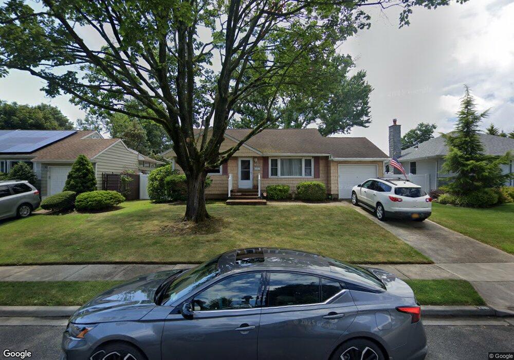
2910 Lindale St Wantagh, NY 11793
Estimated Value: $685,000 - $693,522
3
Beds
1
Bath
1,010
Sq Ft
$682/Sq Ft
Est. Value
About This Home
This home is located at 2910 Lindale St, Wantagh, NY 11793 and is currently estimated at $689,261, approximately $682 per square foot. 2910 Lindale St is a home located in Nassau County with nearby schools including Weatherford West Elementary School, Lt. General Thomas P. Stafford Elementary School, and Grand Avenue Middle School.
Ownership History
Date
Name
Owned For
Owner Type
Purchase Details
Closed on
Mar 18, 2023
Sold by
Marcosano Rose and Chiappone Antonietta
Bought by
Marcosano Rose and Marcosano Michael
Current Estimated Value
Purchase Details
Closed on
Dec 1, 2015
Sold by
Dehayes Edward and Dehayes Teresa
Bought by
Ambrosio Nunzia
Purchase Details
Closed on
Oct 31, 2013
Sold by
Dehayes Edward
Bought by
Dehayes Margaret
Purchase Details
Closed on
Aug 28, 1996
Sold by
Dehayes Margaret
Bought by
Dehayes Margaret
Create a Home Valuation Report for This Property
The Home Valuation Report is an in-depth analysis detailing your home's value as well as a comparison with similar homes in the area
Home Values in the Area
Average Home Value in this Area
Purchase History
| Date | Buyer | Sale Price | Title Company |
|---|---|---|---|
| Marcosano Rose | -- | Abstracts Incorporated | |
| Ambrosio Nunzia | $358,000 | Abstracts Incorporated | |
| Dehayes Margaret | -- | -- | |
| Dehayes Margaret | -- | -- |
Source: Public Records
Tax History Compared to Growth
Tax History
| Year | Tax Paid | Tax Assessment Tax Assessment Total Assessment is a certain percentage of the fair market value that is determined by local assessors to be the total taxable value of land and additions on the property. | Land | Improvement |
|---|---|---|---|---|
| 2025 | $12,158 | $424 | $198 | $226 |
| 2024 | $2,994 | $424 | $198 | $226 |
| 2023 | $8,048 | $424 | $198 | $226 |
| 2022 | $8,048 | $424 | $198 | $226 |
| 2021 | $10,546 | $407 | $190 | $217 |
| 2020 | $7,760 | $574 | $573 | $1 |
| 2019 | $7,293 | $574 | $573 | $1 |
| 2018 | $6,693 | $574 | $0 | $0 |
| 2017 | $3,310 | $574 | $488 | $86 |
| 2016 | $5,870 | $608 | $517 | $91 |
| 2015 | $2,598 | $706 | $600 | $106 |
| 2014 | $2,598 | $706 | $600 | $106 |
| 2013 | $2,437 | $706 | $600 | $106 |
Source: Public Records
Map
Nearby Homes
- 1483 Crown St
- 2800 Pacific St
- 1497 Carroll St
- 2730 Orchard St
- 1680 Cornelius Ave
- 1914 Bergen St
- 1529 Fenimore St
- 1708 Cornelius Ave
- 2889 Anderson St
- 2730 Court St
- 2780 Natta Blvd
- 3019 Post Ave
- 3056 Valentine Place
- 1541 Bellmore Rd
- 2595 Castle Ct
- 17 Hannington Ave
- 1787 Madison Ave
- 1773 Roland Ave
- 2693 Martin Ave
- 1427 Bellmore Rd
- 2904 Lindale St
- 2916 Lindale St
- 2916 Lindale St
- 2898 Lindale St
- 2920 Lindale St
- 2888 Holiday Ct
- 2911 Lindale St
- 2903 Noel Ct
- 2929 Lindale St
- 2892 Lindale St
- 2882 Holiday Ct
- 2881 Gerald Ct
- 2939 Lindale St
- 2885 Gerald Ct
- 2924 Lindale St
- 1583 Peapond Rd
- 2881 Noel Ct
- 2901 Noel Ct
- 2886 Lindale St
- 1569 Peapond Rd