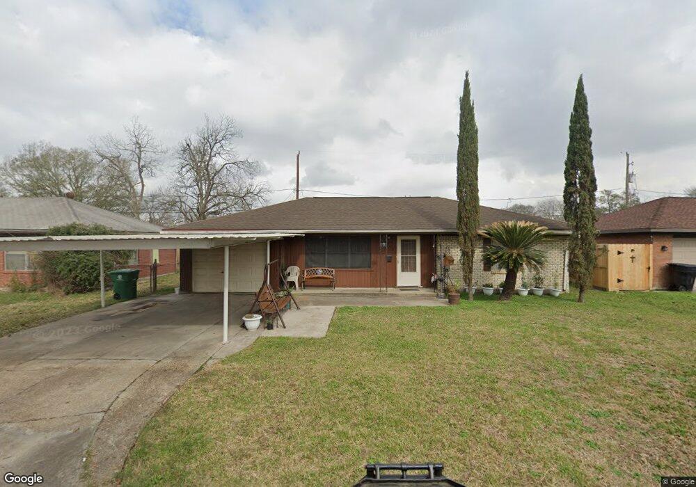
2911 Trenton Rd Houston, TX 77093
Eastex-Jensen NeighborhoodEstimated Value: $174,000 - $187,000
3
Beds
1
Bath
1,411
Sq Ft
$128/Sq Ft
Est. Value
About This Home
This home is located at 2911 Trenton Rd, Houston, TX 77093 and is currently estimated at $180,131, approximately $127 per square foot. 2911 Trenton Rd is a home located in Harris County with nearby schools including Scarborough Elementary School, Patrick Henry Middle School, and Sam Houston Math, Science & Technology Center.
Ownership History
Date
Name
Owned For
Owner Type
Purchase Details
Closed on
Oct 13, 1995
Sold by
Oestreich Susan Renee and Hoisington Robert Richard
Bought by
Zarate Delia G
Current Estimated Value
Home Financials for this Owner
Home Financials are based on the most recent Mortgage that was taken out on this home.
Original Mortgage
$42,250
Outstanding Balance
$297
Interest Rate
7.62%
Estimated Equity
$179,834
Create a Home Valuation Report for This Property
The Home Valuation Report is an in-depth analysis detailing your home's value as well as a comparison with similar homes in the area
Home Values in the Area
Average Home Value in this Area
Purchase History
| Date | Buyer | Sale Price | Title Company |
|---|---|---|---|
| Zarate Delia G | -- | Chicago Title |
Source: Public Records
Mortgage History
| Date | Status | Borrower | Loan Amount |
|---|---|---|---|
| Open | Zarate Delia G | $42,250 |
Source: Public Records
Tax History Compared to Growth
Tax History
| Year | Tax Paid | Tax Assessment Tax Assessment Total Assessment is a certain percentage of the fair market value that is determined by local assessors to be the total taxable value of land and additions on the property. | Land | Improvement |
|---|---|---|---|---|
| 2025 | $1,436 | $173,066 | $49,959 | $123,107 |
| 2024 | $1,436 | $164,282 | $41,175 | $123,107 |
| 2023 | $1,436 | $165,272 | $41,175 | $124,097 |
| 2022 | $2,500 | $150,413 | $27,450 | $122,963 |
| 2021 | $2,406 | $121,218 | $17,843 | $103,375 |
| 2020 | $2,273 | $116,729 | $17,843 | $98,886 |
| 2019 | $2,159 | $110,480 | $15,098 | $95,382 |
| 2018 | $1,276 | $77,558 | $15,098 | $62,460 |
| 2017 | $1,961 | $77,558 | $15,098 | $62,460 |
| 2016 | $1,785 | $70,582 | $15,098 | $55,484 |
| 2015 | $1,585 | $70,582 | $15,098 | $55,484 |
| 2014 | $1,585 | $85,364 | $15,098 | $70,266 |
Source: Public Records
Map
Nearby Homes
- 1728 Little York Rd
- 1904 Little York Rd
- 2636 Lone Oak Rd
- 2629 Kowis St
- 2817 Cromwell St
- 4918 Langley Rd
- 3418 Hopper Rd
- 2315 Langley Rd
- 3804 Cedar Hill Ln
- 2332 Margaret St
- 3214 Brea Crest St
- 2415 Goodloe St
- 2915 Brea Crest St
- 2311 Warwick Rd
- 2237 Cromwell St
- 2152 William Tell St
- 2122 Kowis St
- 3202 Parker Rd
- 2326 Sunny Dr
- 11716 Innsbury Dr
- 2915 Trenton Rd
- 2907 Trenton Rd
- 2912 Cricket Ln
- 2908 Cricket Ln
- 2919 Trenton Rd
- 2916 Cricket Ln
- 2912 Trenton Rd
- 2916 Trenton Rd
- 2908 Trenton Rd
- 2920 Cricket Ln
- 2923 Trenton Rd
- 2920 Trenton Rd
- 10907 Royal Pine Dr
- 10903 Royal Pine Dr
- 10911 Royal Pine Dr
- 10819 Royal Pine Dr
- 2924 Cricket Ln
- 10915 Royal Pine Dr
- 2924 Trenton Rd
- 2927 Trenton Rd