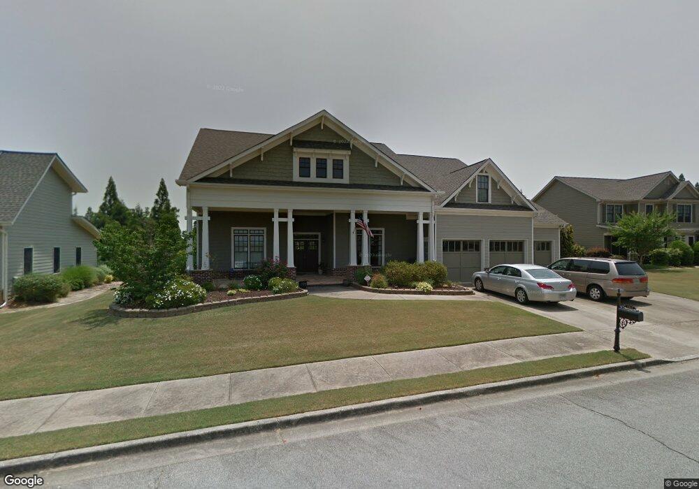
2911 White Azalea St Unit 1 Buford, GA 30519
Estimated Value: $630,082 - $686,000
4
Beds
4
Baths
3,868
Sq Ft
$169/Sq Ft
Est. Value
About This Home
This home is located at 2911 White Azalea St Unit 1, Buford, GA 30519 and is currently estimated at $652,271, approximately $168 per square foot. 2911 White Azalea St Unit 1 is a home located in Hall County with nearby schools including Friendship Elementary School, Cherokee Bluff Middle School, and Cherokee Bluff High School.
Ownership History
Date
Name
Owned For
Owner Type
Purchase Details
Closed on
Dec 9, 2004
Sold by
Battle Properties Inc
Bought by
White Harold D and White Cynthia
Current Estimated Value
Home Financials for this Owner
Home Financials are based on the most recent Mortgage that was taken out on this home.
Original Mortgage
$284,450
Outstanding Balance
$141,788
Interest Rate
5.66%
Mortgage Type
New Conventional
Estimated Equity
$510,483
Purchase Details
Closed on
Oct 17, 2003
Sold by
Landstar Corp
Bought by
Battle Properties Inc
Create a Home Valuation Report for This Property
The Home Valuation Report is an in-depth analysis detailing your home's value as well as a comparison with similar homes in the area
Home Values in the Area
Average Home Value in this Area
Purchase History
| Date | Buyer | Sale Price | Title Company |
|---|---|---|---|
| White Harold D | $355,600 | -- | |
| Battle Properties Inc | $510,300 | -- |
Source: Public Records
Mortgage History
| Date | Status | Borrower | Loan Amount |
|---|---|---|---|
| Open | White Harold D | $284,450 |
Source: Public Records
Tax History Compared to Growth
Tax History
| Year | Tax Paid | Tax Assessment Tax Assessment Total Assessment is a certain percentage of the fair market value that is determined by local assessors to be the total taxable value of land and additions on the property. | Land | Improvement |
|---|---|---|---|---|
| 2024 | $5,927 | $236,200 | $41,600 | $194,600 |
| 2023 | $5,330 | $212,400 | $30,120 | $182,280 |
| 2022 | $4,749 | $181,640 | $30,120 | $151,520 |
| 2021 | $4,263 | $160,040 | $18,600 | $141,440 |
| 2020 | $4,152 | $151,440 | $18,600 | $132,840 |
| 2019 | $4,224 | $152,680 | $19,360 | $133,320 |
| 2018 | $4,452 | $155,800 | $19,000 | $136,800 |
| 2017 | $4,326 | $147,760 | $19,000 | $128,760 |
| 2016 | $3,950 | $138,120 | $20,880 | $117,240 |
| 2015 | $4,070 | $141,224 | $20,880 | $120,344 |
| 2014 | $4,070 | $141,224 | $20,880 | $120,344 |
Source: Public Records
Map
Nearby Homes
- 2941 Climbing Rose St
- 3134 Perimeter Cir
- 4728 Moon Hollow Ct
- 4761 Moon Chase Dr
- 4732 Moon Chase Dr
- 2638 Democracy Dr Unit 1
- 4456 Hosch Reserve Dr
- 4457 Hosch Reserve Dr
- 4447 Hosch Reserve Dr
- 2342 Sparta Way
- 4436 Hosch Reserve Dr
- 4437 Hosch Reserve Dr
- 4416 Hosch Retreat Dr
- 3088 Lantana Way
- 3138 Lantana Way
- 2228 Mayors Way
- 2732 Thompson Mill Rd
- 7343 Peacebrook Dr
- 2907 White Azalea St Unit 1
- 2915 White Azalea St
- 2934 Climbing Rose St
- 2908 White Azalea St
- 2903 White Azalea St
- 2936 Perimeter Cir
- 2940 Perimeter Cir
- 2919 White Azalea St
- 2932 Perimeter Cir
- 2865 Wild Rose St
- 2944 Perimeter Cir
- 2923 White Azalea St
- 2933 Climbing Rose St
- 2857 White Azalea St Unit 57
- 2857 White Azalea St Unit 1
- 2857 White Azalea St
- 2940 Climbing Rose St
- 0 Crimson Ct
- 2869 Wild Rose St
- 2948 Perimeter Cir Unit 2948