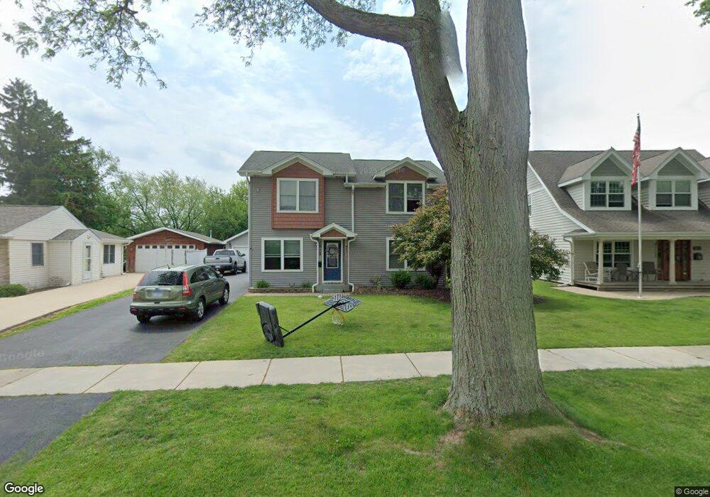
2912 Cardinal Dr Rolling Meadows, IL 60008
Estimated Value: $335,000 - $414,000
3
Beds
2
Baths
2,092
Sq Ft
$179/Sq Ft
Est. Value
About This Home
This home is located at 2912 Cardinal Dr, Rolling Meadows, IL 60008 and is currently estimated at $375,295, approximately $179 per square foot. 2912 Cardinal Dr is a home located in Cook County with nearby schools including Kimball Hill Elementary School, Carl Sandburg Junior High School, and Rolling Meadows High School.
Ownership History
Date
Name
Owned For
Owner Type
Purchase Details
Closed on
Mar 30, 2010
Sold by
Moffet Steven C
Bought by
Moffet Steven Andrew
Current Estimated Value
Purchase Details
Closed on
May 19, 2003
Sold by
Wenzel Orris H
Bought by
Wenzel Orris H and Orris H Wenzel Trust
Purchase Details
Closed on
Jul 17, 2000
Sold by
Czink Katherine R and Czink Katharin R
Bought by
Campbell Mary C
Home Financials for this Owner
Home Financials are based on the most recent Mortgage that was taken out on this home.
Original Mortgage
$126,800
Outstanding Balance
$43,691
Interest Rate
8.31%
Estimated Equity
$331,604
Purchase Details
Closed on
Aug 1, 1997
Sold by
Moscinski Andrew W and Czink Andrea L
Bought by
Czink Rita and Czink Katherine R
Create a Home Valuation Report for This Property
The Home Valuation Report is an in-depth analysis detailing your home's value as well as a comparison with similar homes in the area
Home Values in the Area
Average Home Value in this Area
Purchase History
| Date | Buyer | Sale Price | Title Company |
|---|---|---|---|
| Moffet Steven Andrew | -- | Chicago Title Insurance Co | |
| Wenzel Orris H | -- | -- | |
| Campbell Mary C | $158,500 | 1St American Title | |
| Czink Rita | $92,000 | Attorneys Natl Title Network |
Source: Public Records
Mortgage History
| Date | Status | Borrower | Loan Amount |
|---|---|---|---|
| Open | Campbell Mary C | $126,800 |
Source: Public Records
Tax History
| Year | Tax Paid | Tax Assessment Tax Assessment Total Assessment is a certain percentage of the fair market value that is determined by local assessors to be the total taxable value of land and additions on the property. | Land | Improvement |
|---|---|---|---|---|
| 2025 | $7,565 | $41,000 | $7,085 | $33,915 |
| 2024 | $7,565 | $32,477 | $5,995 | $26,482 |
| 2023 | $7,214 | $32,477 | $5,995 | $26,482 |
| 2022 | $7,214 | $32,477 | $5,995 | $26,482 |
| 2021 | $5,378 | $19,569 | $3,542 | $16,027 |
| 2020 | $5,325 | $19,569 | $3,542 | $16,027 |
| 2019 | $5,363 | $21,865 | $3,542 | $18,323 |
| 2018 | $5,027 | $18,955 | $3,270 | $15,685 |
| 2017 | $4,944 | $18,955 | $3,270 | $15,685 |
| 2016 | $4,865 | $18,955 | $3,270 | $15,685 |
| 2015 | $4,731 | $17,650 | $2,997 | $14,653 |
| 2014 | $4,635 | $17,650 | $2,997 | $14,653 |
| 2013 | $4,506 | $17,650 | $2,997 | $14,653 |
Source: Public Records
Map
Nearby Homes
- 3265 Kirchoff Rd Unit 116
- 3345 Kirchoff Rd Unit 5C
- 3135 Town Square Dr Unit 401
- 3135 Town Square Dr Unit 104
- 3100 Town Square Dr Unit 308
- 3100 Town Square Dr Unit 204
- 2705 Park St
- 3306 Trillium Cir Unit 3001
- 3209 Trillium Cir
- 2401 Rohlwing Rd
- 2709 Lily Ln
- 3200 Thrush Ln
- 2600 Brookwood Way Dr Unit 316
- 2600 Brookwood Way Dr Unit 305
- 3 Holyoke on Auburn
- 2650 Brookwood Way Dr Unit 313
- 2650 Brookwood Way Dr Unit 108
- 399 Knollwood Ct
- 3710 Meadow Dr
- 304 E Tall Trees Ln
- 2910 Cardinal Dr
- 2914 Cardinal Dr
- 2908 Cardinal Dr
- 2916 Cardinal Dr
- 2906 Cardinal Dr
- 2918 Cardinal Dr
- 2909 Cardinal Dr
- 2907 Cardinal Dr
- 2904 Cardinal Dr
- 2911 Cardinal Dr
- 2920 Cardinal Dr
- 2905 Cardinal Dr
- 2915 Cardinal Dr
- 2903 Cardinal Dr
- 3457 Kirchoff Rd
- 3451 Kirchoff Rd
- 2922 Cardinal Dr
- 2922 Cardinal Dr
- 2917 Cardinal Dr
- 3475 Kirchoff Rd
Your Personal Tour Guide
Ask me questions while you tour the home.