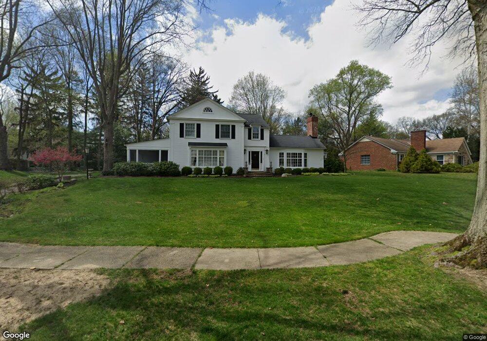
2912 Circle Dr Silver Lake, OH 44224
Estimated Value: $478,216 - $652,000
4
Beds
4
Baths
3,090
Sq Ft
$179/Sq Ft
Est. Value
About This Home
This home is located at 2912 Circle Dr, Silver Lake, OH 44224 and is currently estimated at $554,554, approximately $179 per square foot. 2912 Circle Dr is a home located in Summit County with nearby schools including Silver Lake Elementary School, Roberts Middle School, and Cuyahoga Falls High School.
Ownership History
Date
Name
Owned For
Owner Type
Purchase Details
Closed on
Feb 16, 2026
Sold by
Gosky John J and Gosky Anna L
Bought by
Jasa Trust and Gosky
Current Estimated Value
Purchase Details
Closed on
Nov 30, 1995
Sold by
Wichert Thomas H
Bought by
Schlosser David W and Schlosser Kathryn
Home Financials for this Owner
Home Financials are based on the most recent Mortgage that was taken out on this home.
Original Mortgage
$203,000
Interest Rate
7.44%
Mortgage Type
New Conventional
Create a Home Valuation Report for This Property
The Home Valuation Report is an in-depth analysis detailing your home's value as well as a comparison with similar homes in the area
Home Values in the Area
Average Home Value in this Area
Purchase History
| Date | Buyer | Sale Price | Title Company |
|---|---|---|---|
| Jasa Trust | -- | None Listed On Document | |
| Schlosser David W | $450,000 | -- |
Source: Public Records
Mortgage History
| Date | Status | Borrower | Loan Amount |
|---|---|---|---|
| Previous Owner | Schlosser David W | $203,000 |
Source: Public Records
Tax History
| Year | Tax Paid | Tax Assessment Tax Assessment Total Assessment is a certain percentage of the fair market value that is determined by local assessors to be the total taxable value of land and additions on the property. | Land | Improvement |
|---|---|---|---|---|
| 2025 | $7,911 | $140,288 | $22,684 | $117,604 |
| 2024 | $7,911 | $140,288 | $22,684 | $117,604 |
| 2023 | $7,911 | $140,288 | $22,684 | $117,604 |
| 2022 | $8,051 | $116,908 | $18,904 | $98,004 |
| 2021 | $8,050 | $116,908 | $18,904 | $98,004 |
| 2020 | $7,923 | $116,900 | $18,900 | $98,000 |
| 2019 | $7,867 | $106,050 | $22,120 | $83,930 |
| 2018 | $6,048 | $95,440 | $18,870 | $76,570 |
| 2017 | $5,359 | $95,440 | $18,870 | $76,570 |
| 2016 | $5,363 | $85,690 | $18,870 | $66,820 |
| 2015 | $5,359 | $85,690 | $18,870 | $66,820 |
| 2014 | $5,362 | $85,690 | $18,870 | $66,820 |
| 2013 | $5,235 | $84,350 | $18,870 | $65,480 |
Source: Public Records
Map
Nearby Homes
- 2871 Park Dr N
- 2707 Overbrook Rd
- 3314 Charles Place
- 3041 Hudson Dr
- 2627 Overbrook Rd
- 2822 Lakeland Pkwy
- 431 Trudy Ave
- 2735 3rd St
- 3068 Kent Rd Unit 105
- 3066 Kent Rd Unit 112
- 3064 Kent Rd Unit 403
- 3068 Kent Rd
- 3119 Highland Dr
- 3320 Hudson Dr
- 3114 W Edgerton Rd
- 2452 Clara St
- 1473 Munroe Falls Ave Unit 5
- 2890 Bailey Rd
- 2930 Bailey Rd
- 33 Pierce Ave
- 2918 Circle Dr
- 2891 Hastings Rd
- 2924 Overlook Rd
- 2933 Parkwood Dr
- 2917 Circle Dr
- 2885 Hastings Rd
- 2900 Hastings Rd
- 2896 Hastings Rd
- 2923 Circle Dr
- 2911 Circle Dr
- 2906 Hastings Rd
- 2929 Parkwood Dr
- 2890 Hastings Rd
- 2910 Hastings Rd
- 2881 Hastings Rd
- 2925 Cirlce Dr
- 2925 Circle Dr
- 2925 Parkwood Dr
- 2915 Hastings Rd
- 2897 Lee Rd
Your Personal Tour Guide
Ask me questions while you tour the home.