Estimated Value: $291,633 - $321,000
3
Beds
2
Baths
1,569
Sq Ft
$194/Sq Ft
Est. Value
About This Home
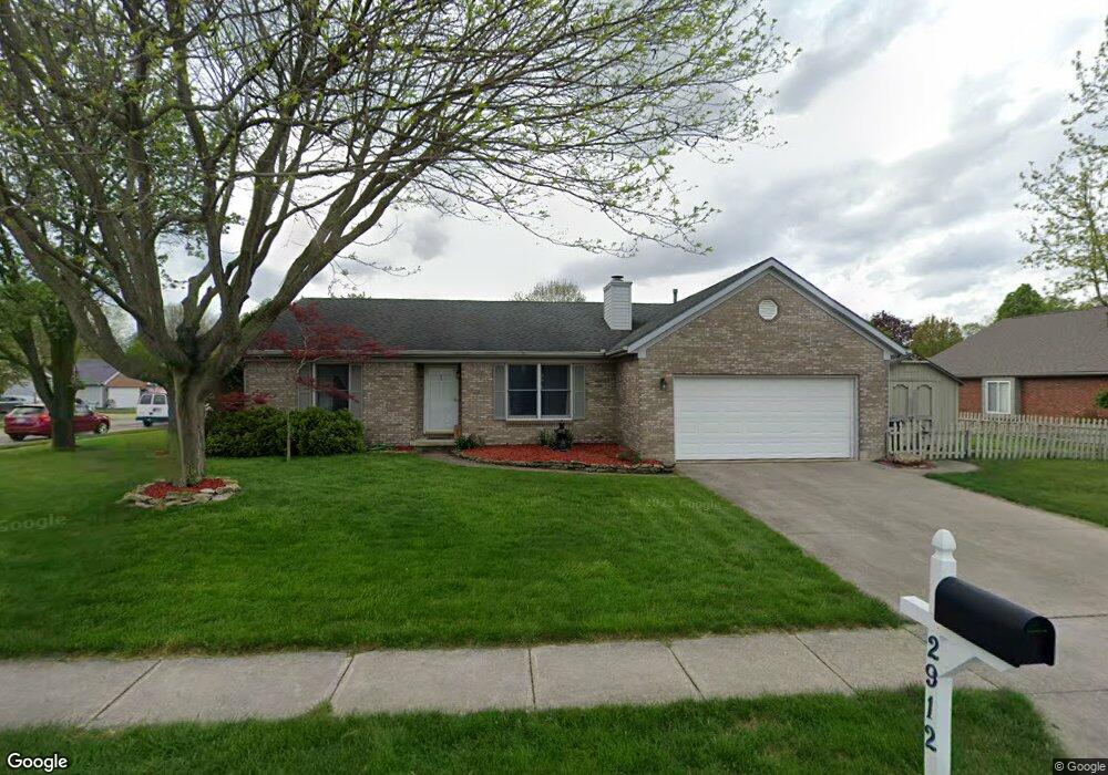
This home is located at 2912 Red Oak Cir, Troy, OH 45373 and is currently estimated at $304,408, approximately $194 per square foot. 2912 Red Oak Cir is a home located in Miami County with nearby schools including Concord Elementary School, Van Cleve Elementary School, and Troy Junior High School.
Ownership History
Date
Name
Owned For
Owner Type
Purchase Details
Closed on
Aug 5, 2004
Sold by
Cleary Gary W and Cleary Debra S
Bought by
Szafranski Daniel J and Szafranski Yasuko N
Current Estimated Value
Home Financials for this Owner
Home Financials are based on the most recent Mortgage that was taken out on this home.
Original Mortgage
$121,200
Outstanding Balance
$61,453
Interest Rate
6.34%
Mortgage Type
New Conventional
Estimated Equity
$242,955
Purchase Details
Closed on
Jul 5, 2002
Sold by
Cleary Gary W
Bought by
Cleary Gary W and Cleary Debra S
Create a Home Valuation Report for This Property
The Home Valuation Report is an in-depth analysis detailing your home's value as well as a comparison with similar homes in the area
Home Values in the Area
Average Home Value in this Area
Purchase History
| Date | Buyer | Sale Price | Title Company |
|---|---|---|---|
| Szafranski Daniel J | $151,500 | -- | |
| Cleary Gary W | -- | -- |
Source: Public Records
Mortgage History
| Date | Status | Borrower | Loan Amount |
|---|---|---|---|
| Open | Cleary Gary W | $121,200 |
Source: Public Records
Tax History Compared to Growth
Tax History
| Year | Tax Paid | Tax Assessment Tax Assessment Total Assessment is a certain percentage of the fair market value that is determined by local assessors to be the total taxable value of land and additions on the property. | Land | Improvement |
|---|---|---|---|---|
| 2024 | $2,758 | $70,990 | $13,690 | $57,300 |
| 2023 | $2,758 | $70,990 | $13,690 | $57,300 |
| 2022 | $2,310 | $70,990 | $13,690 | $57,300 |
| 2021 | $2,051 | $59,150 | $11,410 | $47,740 |
| 2020 | $2,053 | $59,150 | $11,410 | $47,740 |
| 2019 | $2,071 | $59,150 | $11,410 | $47,740 |
| 2018 | $1,847 | $50,230 | $12,320 | $37,910 |
| 2017 | $1,864 | $50,230 | $12,320 | $37,910 |
| 2016 | $1,838 | $50,230 | $12,320 | $37,910 |
| 2015 | $1,770 | $46,520 | $11,410 | $35,110 |
| 2014 | $1,770 | $46,520 | $11,410 | $35,110 |
| 2013 | $1,782 | $46,520 | $11,410 | $35,110 |
Source: Public Records
Map
Nearby Homes
- 2765 Silver Maple Ct
- 445 Wisteria Dr
- 660 Wisteria Dr
- 203 Boone Dr
- 0 Lincolnshire Unit 939331
- 1701 Chevington Chase
- 2215 Merrimont Dr
- 1117 Honeydew Dr
- 1216 Wind Rock Ct
- 2065 S Co Road 25a
- 768 Stonehenge Dr
- Spruce Plan at Summit Landing
- Norway Plan at Summit Landing
- Chestnut Plan at Summit Landing
- Juniper Plan at Summit Landing
- Palmetto Plan at Summit Landing
- Ashton Plan at Summit Landing
- Empress Plan at Summit Landing
- Ironwood Plan at Summit Landing
- Aspen II Plan at Summit Landing
- 229 Locust View Way
- 2896 Red Oak Cir
- 185 Locust View Way
- 2905 Walnut Ridge Dr
- 2882 Red Oak Cir
- 2901 Red Oak Cir
- 216 Locust View Way
- 202 Locust View Way
- 2897 Walnut Ridge Dr
- 230 Locust View Way
- 2885 Red Oak Cir
- 190 Locust View Way
- 240 Locust View Way
- 2870 Red Oak Cir
- 176 Locust View Way
- 2881 Walnut Ridge Dr
- 2633 Walnut Ridge Dr
- 2875 Red Oak Cir
- 2643 Walnut Ridge Dr
- 215 Green Oak Dr