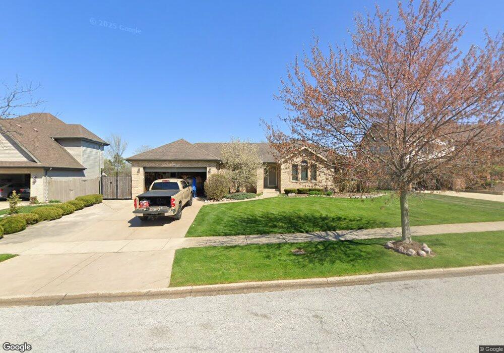
2915 Burge Dr Crown Point, IN 46307
Estimated Value: $334,911 - $419,000
3
Beds
2
Baths
3,264
Sq Ft
$119/Sq Ft
Est. Value
About This Home
This home is located at 2915 Burge Dr, Crown Point, IN 46307 and is currently estimated at $389,228, approximately $119 per square foot. 2915 Burge Dr is a home located in Lake County with nearby schools including Peifer Elementary School, Hal E Clark Middle School, and Lake Central High School.
Ownership History
Date
Name
Owned For
Owner Type
Purchase Details
Closed on
Dec 1, 2022
Sold by
Bouziotis Harry J
Bought by
Harry J Bouziotis Revocable Trust
Current Estimated Value
Purchase Details
Closed on
Aug 3, 2016
Sold by
Bouziotis Harry J and Bouziotis Lynn
Bought by
Bouziotis Harry J
Home Financials for this Owner
Home Financials are based on the most recent Mortgage that was taken out on this home.
Original Mortgage
$124,500
Interest Rate
3.41%
Mortgage Type
New Conventional
Create a Home Valuation Report for This Property
The Home Valuation Report is an in-depth analysis detailing your home's value as well as a comparison with similar homes in the area
Home Values in the Area
Average Home Value in this Area
Purchase History
| Date | Buyer | Sale Price | Title Company |
|---|---|---|---|
| Harry J Bouziotis Revocable Trust | -- | -- | |
| Bouziotis Harry J | -- | None Available |
Source: Public Records
Mortgage History
| Date | Status | Borrower | Loan Amount |
|---|---|---|---|
| Previous Owner | Bouziotis Harry J | $124,500 |
Source: Public Records
Tax History
| Year | Tax Paid | Tax Assessment Tax Assessment Total Assessment is a certain percentage of the fair market value that is determined by local assessors to be the total taxable value of land and additions on the property. | Land | Improvement |
|---|---|---|---|---|
| 2025 | $2,933 | $371,700 | $70,600 | $301,100 |
| 2024 | $6,543 | $352,700 | $70,600 | $282,100 |
| 2023 | $2,880 | $321,300 | $70,600 | $250,700 |
| 2022 | $2,880 | $289,300 | $70,600 | $218,700 |
| 2021 | $2,701 | $277,500 | $70,600 | $206,900 |
| 2020 | $2,538 | $258,200 | $55,500 | $202,700 |
| 2019 | $2,669 | $248,900 | $51,800 | $197,100 |
| 2018 | $2,636 | $243,900 | $51,800 | $192,100 |
| 2017 | $2,331 | $230,900 | $51,800 | $179,100 |
| 2016 | $2,226 | $222,400 | $51,800 | $170,600 |
| 2014 | $1,945 | $208,500 | $51,800 | $156,700 |
| 2013 | $2,002 | $208,600 | $51,800 | $156,800 |
Source: Public Records
Map
Nearby Homes
- 2952 Freedom Cir
- 2914 Morningside Dr
- 1795 Wedgewood Ct
- 8323 Fairbanks St Unit 3E
- 2756 Autumn Dr
- 5547 Victoria Place
- 6076 Wexford Way
- 5980 Wexford Way
- 1444 Woodview Dr Unit 7
- 7139 W 83rd Place
- 10920 Missouri Place
- 6440 W 89th Ave
- 7552 W 82nd Ct
- 8777 Burr Ridge Cir
- 10406 Whitney Place
- 10444 Whitney Place
- 10474 Whitney Place
- 10467 Whitney Place
- 10475 Whitney Place
- 8690 Durbin Ln
Your Personal Tour Guide
Ask me questions while you tour the home.