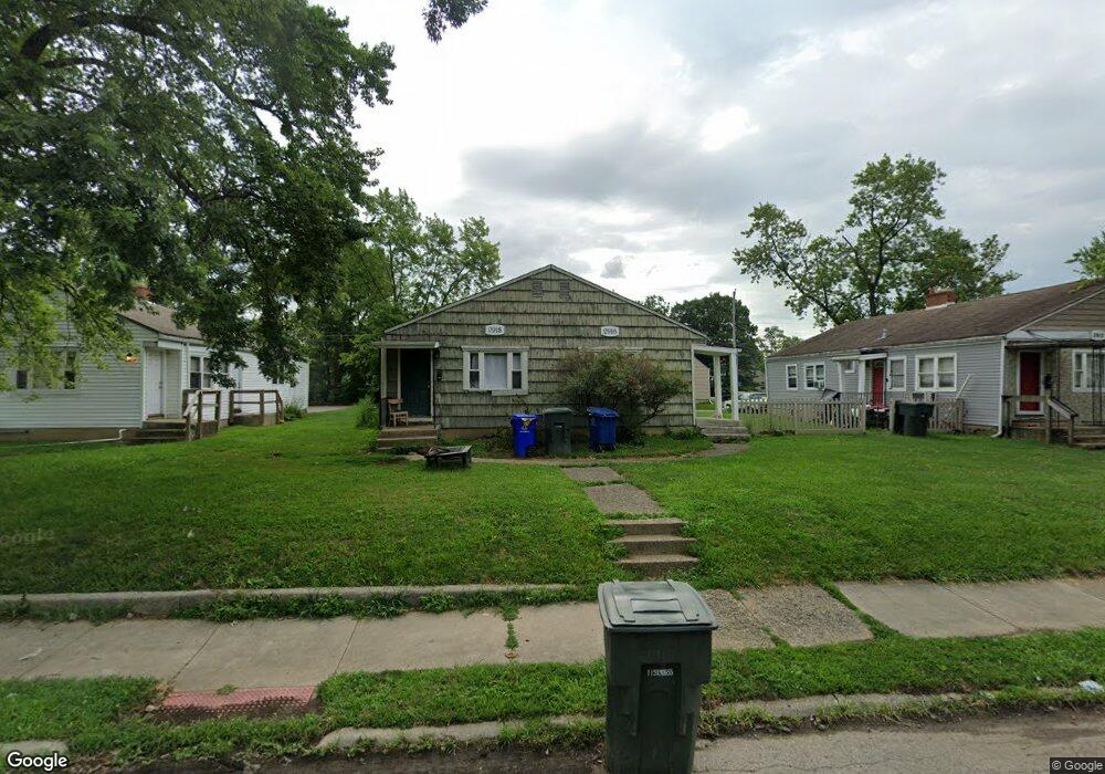
2916-2918 McGuffey Rd Columbus, OH 43224
North Linden NeighborhoodEstimated Value: $181,203 - $218,000
4
Beds
2
Baths
1,576
Sq Ft
$126/Sq Ft
Est. Value
About This Home
This home is located at 2916-2918 McGuffey Rd, Columbus, OH 43224 and is currently estimated at $198,551, approximately $125 per square foot. 2916-2918 McGuffey Rd is a home located in Franklin County with nearby schools including Como Elementary School, Dominion Middle School, and Whetstone High School.
Ownership History
Date
Name
Owned For
Owner Type
Purchase Details
Closed on
Nov 7, 2008
Sold by
Us Bank National Association
Bought by
Dranichak Michelle L and Dranichak Edward J
Current Estimated Value
Purchase Details
Closed on
Jul 23, 2008
Sold by
Jackson Adam
Bought by
Us Bank Na and Citigroup Mortgage Loan Trust 2006-Wfhe2
Purchase Details
Closed on
Mar 1, 1985
Purchase Details
Closed on
May 1, 1983
Create a Home Valuation Report for This Property
The Home Valuation Report is an in-depth analysis detailing your home's value as well as a comparison with similar homes in the area
Home Values in the Area
Average Home Value in this Area
Purchase History
| Date | Buyer | Sale Price | Title Company |
|---|---|---|---|
| Dranichak Michelle L | $20,300 | Accutitle Agency Inc | |
| Us Bank Na | $30,000 | None Available | |
| -- | -- | -- | |
| -- | -- | -- |
Source: Public Records
Tax History Compared to Growth
Tax History
| Year | Tax Paid | Tax Assessment Tax Assessment Total Assessment is a certain percentage of the fair market value that is determined by local assessors to be the total taxable value of land and additions on the property. | Land | Improvement |
|---|---|---|---|---|
| 2024 | $2,219 | $48,410 | $12,850 | $35,560 |
| 2023 | $2,191 | $48,405 | $12,845 | $35,560 |
| 2022 | $1,111 | $20,900 | $5,780 | $15,120 |
| 2021 | $1,113 | $20,900 | $5,780 | $15,120 |
| 2020 | $1,114 | $20,900 | $5,780 | $15,120 |
| 2019 | $1,084 | $17,430 | $4,830 | $12,600 |
| 2018 | $920 | $17,430 | $4,830 | $12,600 |
| 2017 | $958 | $17,430 | $4,830 | $12,600 |
| 2016 | $833 | $12,260 | $4,800 | $7,460 |
| 2015 | $758 | $12,260 | $4,800 | $7,460 |
| 2014 | $760 | $12,260 | $4,800 | $7,460 |
| 2013 | $375 | $12,250 | $4,795 | $7,455 |
Source: Public Records
Map
Nearby Homes
- 2860 Grasmere Ave
- 2950 Grasmere Ave
- 1225 Sandlin Ave
- 2888 Howey Rd
- 2804 Grasmere Ave
- 2913 Gerbert Rd
- 2769 McGuffey Rd
- 2899 Howey Rd
- 1247 Weldon Ave
- 2905 Ontario St
- 2981 Gerbert Rd
- 3043 McGuffey Rd
- 2783 Howey Rd
- 2696 Grasmere Ave
- 3071 Karl Rd
- 2816 Azelda St
- 1269 Minnesota Ave
- 2810-2812 Azelda St
- 3129 McGuffey Rd
- 2767 Hiawatha St
- 2916 McGuffey Rd Unit 18
- 2910 McGuffey Rd Unit 12
- 2924 McGuffey Rd Unit 26
- 1180 Abner Ave
- 2932-2934 McGuffey Rd
- 2932-2934 McGuffey Rd Unit 34
- 2932 McGuffey Rd Unit 34
- 1187 Delno Ave
- 1186 Abner Ave
- 2896 McGuffey Rd Unit 898
- 1193 Delno Ave
- 2919 McGuffey Rd
- 2915 McGuffey Rd Unit 917
- 2911 McGuffey Rd
- 1192 Abner Ave
- 2903 McGuffey Rd
- 1179 Abner Ave
- 1199 Delno Ave
- 2888 McGuffey Rd Unit 890
- 2948 McGuffey Rd Unit 50