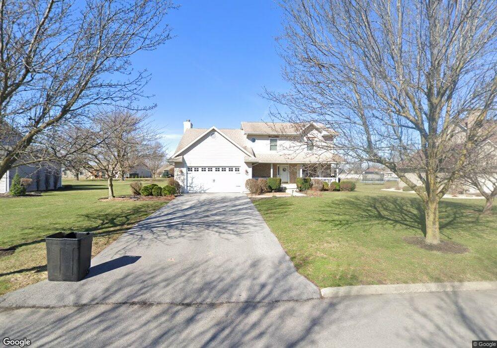
2918 Innisbrook Dr Findlay, OH 45840
Estimated Value: $392,958 - $441,000
4
Beds
3
Baths
2,264
Sq Ft
$184/Sq Ft
Est. Value
About This Home
This home is located at 2918 Innisbrook Dr, Findlay, OH 45840 and is currently estimated at $416,990, approximately $184 per square foot. 2918 Innisbrook Dr is a home located in Hancock County with nearby schools including Liberty-Benton Elementary School, Liberty-Benton Middle School, and Liberty-Benton High School.
Ownership History
Date
Name
Owned For
Owner Type
Purchase Details
Closed on
Oct 28, 2020
Sold by
Rethorn Peter B and Rethorn Lena S
Bought by
Rethorn Peter B and Rethorn Lena S
Current Estimated Value
Purchase Details
Closed on
Mar 1, 2000
Sold by
Foltz Allan J
Bought by
Rethorn Peter B and Rethorn Lena S
Home Financials for this Owner
Home Financials are based on the most recent Mortgage that was taken out on this home.
Original Mortgage
$163,800
Interest Rate
8.27%
Mortgage Type
New Conventional
Purchase Details
Closed on
Jul 2, 1991
Bought by
Foltz Allan J and Foltz Barbara J
Purchase Details
Closed on
Nov 21, 1989
Bought by
Findlay Hillcrest Golf Crs
Create a Home Valuation Report for This Property
The Home Valuation Report is an in-depth analysis detailing your home's value as well as a comparison with similar homes in the area
Home Values in the Area
Average Home Value in this Area
Purchase History
| Date | Buyer | Sale Price | Title Company |
|---|---|---|---|
| Rethorn Peter B | -- | None Available | |
| Rethorn Peter B | $182,000 | -- | |
| Foltz Allan J | $23,500 | -- | |
| Findlay Hillcrest Golf Crs | -- | -- |
Source: Public Records
Mortgage History
| Date | Status | Borrower | Loan Amount |
|---|---|---|---|
| Previous Owner | Rethorn Peter B | $163,800 |
Source: Public Records
Tax History Compared to Growth
Tax History
| Year | Tax Paid | Tax Assessment Tax Assessment Total Assessment is a certain percentage of the fair market value that is determined by local assessors to be the total taxable value of land and additions on the property. | Land | Improvement |
|---|---|---|---|---|
| 2024 | $3,711 | $99,830 | $18,520 | $81,310 |
| 2023 | $3,623 | $99,830 | $18,520 | $81,310 |
| 2022 | $3,588 | $99,830 | $18,520 | $81,310 |
| 2021 | $3,402 | $83,540 | $18,520 | $65,020 |
| 2020 | $3,430 | $83,540 | $18,520 | $65,020 |
| 2019 | $3,291 | $83,540 | $18,520 | $65,020 |
| 2018 | $2,793 | $78,250 | $13,230 | $65,020 |
| 2017 | $1,441 | $78,250 | $13,230 | $65,020 |
| 2016 | $2,796 | $78,250 | $13,230 | $65,020 |
| 2015 | $2,356 | $64,340 | $12,500 | $51,840 |
| 2014 | $2,378 | $64,340 | $12,500 | $51,840 |
| 2012 | $2,484 | $64,340 | $12,500 | $51,840 |
Source: Public Records
Map
Nearby Homes
- 1405 Cypress Lake
- 3106 Saddlebrook
- 3018 Gleneagle Dr
- 6535 Silver Lake Dr
- 933 Laurel Ln
- 1310 Muirfield Dr
- 0 County Road 95 Unit 6097574
- 925 W Melrose Ave
- 905 W Melrose Ave
- 0 County Road 140
- 0 Bushwillow Dr Or Rock Candy Rd Unit Lot 157
- 0 Rock Candy Rd Or Bushwillow Dr Unit Lot 173
- 615 Hillcrest Ave
- 0 Rock Candy Rd Unit Lot 159
- 0 Rock Candy Rd Unit Lot 170
- 0 Rock Candy Rd Unit Lot 172 206819
- 0 Rock Candy Rd Unit Lot 162
- 0 Rock Candy Rd Unit Lot 171
- 0 Rock Candy Rd Unit Lot 168
- 0 Bearcat Way Or Rock Candy Rd Unit Lot 167
- 2912 Innisbrook Dr
- 2924 Innisbrook Dr
- 2915 Turnberry Dr
- 2906 Innisbrook Dr
- 2915 Innisbrook Dr
- 2932 Innisbrook Dr
- 2921 Innisbrook Dr
- 2907 Turnberry Dr
- 2909 Innisbrook Dr
- 2921 Turnberry Dr
- 2927 Innisbrook Dr
- 2900 Innisbrook Dr
- 1407 Brook Lawn
- 2901 Innisbrook Dr
- 1413 Brook Lawn
- 2935 Innisbrook Dr
- 2901 Turnberry Dr
- 2929 Turnberry Dr
- 2940 Saddlebrook
- 3000 Saddlebrook