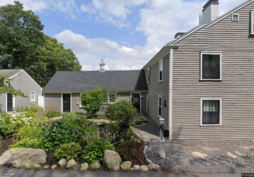
292 Crawford St Northborough, MA 01532
Estimated Value: $777,000 - $916,000
5
Beds
2
Baths
2,886
Sq Ft
$292/Sq Ft
Est. Value
About This Home
This home is located at 292 Crawford St, Northborough, MA 01532 and is currently estimated at $841,915, approximately $291 per square foot. 292 Crawford St is a home located in Worcester County with nearby schools including Lincoln Street Elementary School, Robert E. Melican Middle School, and Algonquin Regional High School.
Ownership History
Date
Name
Owned For
Owner Type
Purchase Details
Closed on
May 18, 2015
Sold by
Est Percy Robert B and Hart Clinton B
Bought by
Marcoux Caroline P
Current Estimated Value
Purchase Details
Closed on
Feb 4, 2015
Sold by
Pryor Jonathan M and Pryor Gina M
Bought by
Pryor Jonathan M and Pryor Gina
Purchase Details
Closed on
Apr 27, 2011
Sold by
Est Percy Robert B and Hart Clinton B
Bought by
Pryor Jonathan M and Mannone Catherine
Home Financials for this Owner
Home Financials are based on the most recent Mortgage that was taken out on this home.
Original Mortgage
$220,000
Interest Rate
4.76%
Mortgage Type
Purchase Money Mortgage
Purchase Details
Closed on
Sep 20, 2010
Sold by
Stearns Donna
Bought by
Stearns Brian and Stearns Donna
Purchase Details
Closed on
Nov 17, 2009
Sold by
Hart Clinton B and Percy Robert B
Bought by
Stearns Donna
Create a Home Valuation Report for This Property
The Home Valuation Report is an in-depth analysis detailing your home's value as well as a comparison with similar homes in the area
Home Values in the Area
Average Home Value in this Area
Purchase History
| Date | Buyer | Sale Price | Title Company |
|---|---|---|---|
| Marcoux Caroline P | -- | -- | |
| Pryor Jonathan M | -- | -- | |
| Pryor Jonathan M | $275,000 | -- | |
| Stearns Brian | -- | -- | |
| Stearns Donna | $230,000 | -- |
Source: Public Records
Mortgage History
| Date | Status | Borrower | Loan Amount |
|---|---|---|---|
| Previous Owner | Pryor Jonathan M | $220,000 |
Source: Public Records
Tax History Compared to Growth
Tax History
| Year | Tax Paid | Tax Assessment Tax Assessment Total Assessment is a certain percentage of the fair market value that is determined by local assessors to be the total taxable value of land and additions on the property. | Land | Improvement |
|---|---|---|---|---|
| 2025 | $10,296 | $722,500 | $317,800 | $404,700 |
| 2024 | $9,133 | $639,600 | $253,400 | $386,200 |
| 2023 | $9,328 | $630,700 | $239,000 | $391,700 |
| 2022 | $9,081 | $550,700 | $227,800 | $322,900 |
| 2021 | $8,709 | $508,700 | $207,400 | $301,300 |
| 2020 | $8,672 | $502,700 | $195,800 | $306,900 |
| 2019 | $8,417 | $490,800 | $190,200 | $300,600 |
| 2018 | $8,403 | $483,200 | $185,100 | $298,100 |
| 2017 | $8,048 | $462,800 | $185,100 | $277,700 |
| 2016 | $7,730 | $450,200 | $181,500 | $268,700 |
| 2015 | $7,092 | $423,900 | $192,400 | $231,500 |
| 2014 | -- | $410,900 | $192,400 | $218,500 |
Source: Public Records
Map
Nearby Homes
- 282 Crawford St
- 295 Crawford St
- 279 Crawford St
- 276 Crawford St
- 298 Crawford St
- 294 Crawford St
- 294A Crawford St
- 300 Crawford St
- 272 Crawford St
- 296 Crawford St
- 289 Crawford St
- 258 Crawford St
- 297 Crawford St
- 297 Crawford St
- 297 Crawford St
- 297 Crawford St
- 297 Crawford St
- 308 Crawford St
- 317 Crawford St
- 255 Crawford St