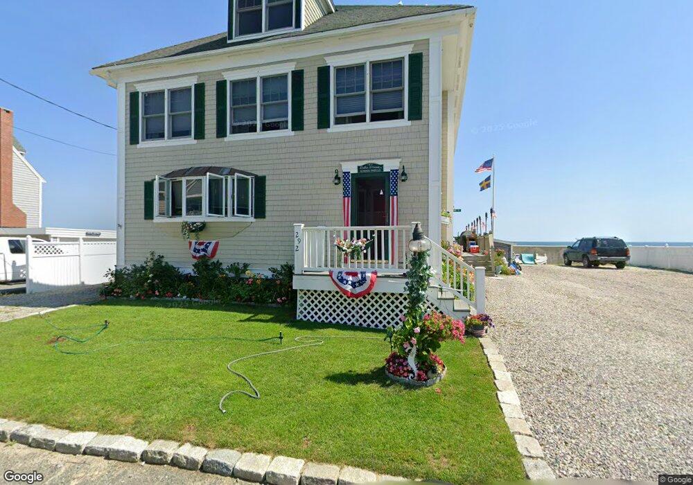
292 Foster Ave Marshfield, MA 02050
Ocean Bluff-Brant Rock NeighborhoodEstimated Value: $1,061,000 - $1,371,659
5
Beds
2
Baths
2,840
Sq Ft
$454/Sq Ft
Est. Value
About This Home
This home is located at 292 Foster Ave, Marshfield, MA 02050 and is currently estimated at $1,289,165, approximately $453 per square foot. 292 Foster Ave is a home with nearby schools including Daniel Webster, Furnace Brook Middle School, and Marshfield High School.
Ownership History
Date
Name
Owned For
Owner Type
Purchase Details
Closed on
Jun 23, 2021
Sold by
Adams Glenda R
Bought by
Glenda R Adams Irt and Lamonica
Current Estimated Value
Purchase Details
Closed on
Oct 30, 1998
Sold by
Lisowski Joseph A and Lisowski Marianne
Bought by
Adams Theodore D and Adams Glnda R
Purchase Details
Closed on
Jul 31, 1998
Sold by
Lisowski James B and Lisowski Janet E
Bought by
Lisowski Joseph A and Lisowski Marianne
Purchase Details
Closed on
May 13, 1994
Sold by
Home Savings America
Bought by
Lisowski James B and Warren Janet E
Purchase Details
Closed on
Jul 15, 1993
Sold by
Kilgarriff Thomas J and Home Sav Of America
Bought by
Home Svgs Of America
Create a Home Valuation Report for This Property
The Home Valuation Report is an in-depth analysis detailing your home's value as well as a comparison with similar homes in the area
Home Values in the Area
Average Home Value in this Area
Purchase History
| Date | Buyer | Sale Price | Title Company |
|---|---|---|---|
| Glenda R Adams Irt | -- | None Available | |
| Glenda R Adams Irt | -- | None Available | |
| Adams Theodore D | $228,750 | -- | |
| Adams Theodore D | $228,750 | -- | |
| Lisowski Joseph A | $37,000 | -- | |
| Lisowski Joseph A | $37,000 | -- | |
| Lisowski James B | $185,000 | -- | |
| Home Svgs Of America | $294,917 | -- |
Source: Public Records
Mortgage History
| Date | Status | Borrower | Loan Amount |
|---|---|---|---|
| Previous Owner | Home Svgs Of America | $316,000 | |
| Previous Owner | Home Svgs Of America | $212,500 |
Source: Public Records
Tax History
| Year | Tax Paid | Tax Assessment Tax Assessment Total Assessment is a certain percentage of the fair market value that is determined by local assessors to be the total taxable value of land and additions on the property. | Land | Improvement |
|---|---|---|---|---|
| 2025 | $13,370 | $1,350,500 | $841,500 | $509,000 |
| 2024 | $12,515 | $1,204,500 | $761,300 | $443,200 |
| 2023 | $11,071 | $1,093,500 | $721,300 | $372,200 |
| 2022 | $11,071 | $854,900 | $551,000 | $303,900 |
| 2021 | $10,028 | $760,300 | $470,800 | $289,500 |
| 2020 | $9,544 | $716,000 | $440,800 | $275,200 |
| 2019 | $9,387 | $701,600 | $440,800 | $260,800 |
| 2018 | $9,380 | $701,600 | $440,800 | $260,800 |
| 2017 | $9,409 | $685,800 | $440,800 | $245,000 |
| 2016 | $9,359 | $674,300 | $440,800 | $233,500 |
| 2015 | $10,026 | $754,400 | $520,900 | $233,500 |
| 2014 | $9,359 | $704,200 | $480,800 | $223,400 |
Source: Public Records
Map
Nearby Homes
- 85 Constitution Rd
- 122 June St
- 78 Tower Ave
- 32 Gratto Rd
- 155 Quincy Ave
- 17 Dyke Rd
- 30 Chandler Dr
- 116 Island St
- 106 Careswell St
- 42 Carr Rd
- 7 Pierce Rd
- 1192 S River St
- 255 Ridge Rd
- 92 Salt Meadow Waye
- 86 Telegraph Hill Rd
- 39 High Beacon Way
- 16 Schooner Way
- 116 Outlook Rd
- 29 Spyglass Landing Dr
- 86 Barouche Dr
- 293 Foster Ave
- 4 13th Rd Unit OCEANFRONT
- 4 13th Rd
- 4 Thirteenth Rd
- 8 13th Rd
- 284 Foster Ave
- 14 13th Rd
- 14 12th Rd
- 280 Foster Ave
- 12 Joyce St
- 16 Joyce St
- 23 13th Rd
- 278 Foster Ave
- 22 12th Rd Unit 1
- 13 12th Rd
- 274 Foster Ave
- 274 Foster Ave Unit 1
- 274 Foster Ave
- 28 13th Rd Unit 28
- 28 13th Rd Unit WINTER rent
Your Personal Tour Guide
Ask me questions while you tour the home.