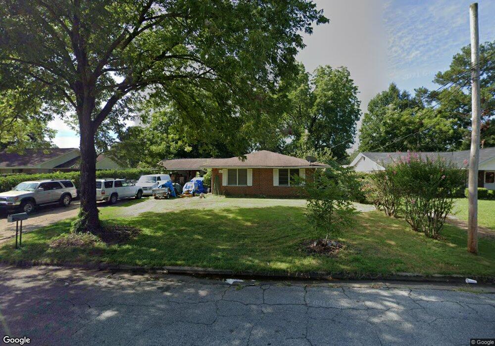
2922 Avondale Rd Columbus, GA 31903
Southern Columbus NeighborhoodEstimated Value: $112,000 - $148,000
3
Beds
3
Baths
1,528
Sq Ft
$86/Sq Ft
Est. Value
About This Home
This home is located at 2922 Avondale Rd, Columbus, GA 31903 and is currently estimated at $131,473, approximately $86 per square foot. 2922 Avondale Rd is a home located in Muscogee County with nearby schools including South Columbus Elementary School, Eddy Middle School, and Spencer High School.
Ownership History
Date
Name
Owned For
Owner Type
Purchase Details
Closed on
Jun 23, 2022
Sold by
Kirk David L
Bought by
Willis Charles
Current Estimated Value
Purchase Details
Closed on
Jan 30, 2018
Sold by
Kirks David L
Bought by
Kirk L David
Purchase Details
Closed on
Apr 13, 2011
Sold by
Redmond Thoms Richard
Bought by
Wammack Mavis and Wammack James T
Create a Home Valuation Report for This Property
The Home Valuation Report is an in-depth analysis detailing your home's value as well as a comparison with similar homes in the area
Home Values in the Area
Average Home Value in this Area
Purchase History
| Date | Buyer | Sale Price | Title Company |
|---|---|---|---|
| Willis Charles | -- | None Listed On Document | |
| Kirk L David | -- | None Listed On Document | |
| Wammack Mavis | $70,000 | -- |
Source: Public Records
Tax History Compared to Growth
Tax History
| Year | Tax Paid | Tax Assessment Tax Assessment Total Assessment is a certain percentage of the fair market value that is determined by local assessors to be the total taxable value of land and additions on the property. | Land | Improvement |
|---|---|---|---|---|
| 2025 | $2,673 | $47,656 | $4,252 | $43,404 |
| 2024 | $1,205 | $43,988 | $4,252 | $39,736 |
| 2023 | $1,733 | $43,988 | $4,252 | $39,736 |
| 2022 | $1,487 | $36,424 | $4,252 | $32,172 |
| 2021 | $1,407 | $34,340 | $4,252 | $30,088 |
| 2020 | $1,402 | $34,340 | $4,252 | $30,088 |
| 2019 | $1,407 | $34,340 | $4,252 | $30,088 |
| 2018 | $1,378 | $33,644 | $4,252 | $29,392 |
| 2017 | $1,383 | $33,644 | $4,252 | $29,392 |
| 2016 | $1,564 | $37,914 | $3,450 | $34,464 |
| 2015 | $626 | $37,914 | $3,450 | $34,464 |
| 2014 | $627 | $37,914 | $3,450 | $34,464 |
| 2013 | -- | $37,914 | $3,450 | $34,464 |
Source: Public Records
Map
Nearby Homes
- 3009 Plantation Rd
- 2973 Hawthorne Dr
- 2102 Somerset Ave
- 3042 Colonial Dr
- 2451 Brownie Ln
- 1274 Providence Ln
- 2463 Brownie Ln
- 3015 Hendrix St
- 2463 Brownie St
- 2203 Simmons Ave
- 2333 Bruce Ave
- 2309 Ginny Ave
- 2404 Bruce Ave
- 3310 Albert St
- 2425 Howe Ave
- 2313 Dorothy Ave
- 3135 Baker Cir
- 2417 Manning Ave
- 3110 Victory Dr
- 1029 Harbison Dr
- 2918 Avondale Rd
- 2926 Avondale Rd
- 2921 Emory St
- 2925 Emory St
- 2914 Avondale Rd
- 2930 Avondale Rd
- 2917 Emory St
- 2929 Emory St
- 2921 Avondale Rd
- 2925 Avondale Rd
- 2917 Avondale Rd
- 2910 Avondale Rd
- 2913 Emory St
- 2931 Emory St
- 2934 Avondale Rd
- 2913 Avondale Rd
- 2929 Avondale Rd
- 2909 Emory St
- 2935 Emory St
- 2906 Avondale Rd