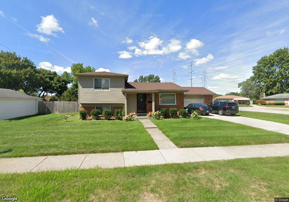
29245 Newport Dr Warren, MI 48088
Northeast Warren NeighborhoodEstimated Value: $272,000 - $290,000
3
Beds
2
Baths
1,743
Sq Ft
$161/Sq Ft
Est. Value
About This Home
This home is located at 29245 Newport Dr, Warren, MI 48088 and is currently estimated at $280,267, approximately $160 per square foot. 29245 Newport Dr is a home located in Macomb County with nearby schools including Warren Woods Tower High School, Frontier International Academy Elementary, and Warren Woods Christian School.
Ownership History
Date
Name
Owned For
Owner Type
Purchase Details
Closed on
Aug 28, 2025
Sold by
Chiodo Joseph G and Chiodo John L
Bought by
Chiodo Joseph G and Chiodo John L
Current Estimated Value
Purchase Details
Closed on
Dec 19, 2018
Sold by
Chiodo Joseph O
Bought by
Chiodo Joseph O and Chiodo John L
Home Financials for this Owner
Home Financials are based on the most recent Mortgage that was taken out on this home.
Original Mortgage
$82,500
Interest Rate
3.4%
Mortgage Type
New Conventional
Purchase Details
Closed on
Sep 12, 2007
Sold by
Chiodo Dominico and Chiodo Virginia
Bought by
Chiodo Dominico and Dominico Chiodo Trust
Create a Home Valuation Report for This Property
The Home Valuation Report is an in-depth analysis detailing your home's value as well as a comparison with similar homes in the area
Home Values in the Area
Average Home Value in this Area
Purchase History
| Date | Buyer | Sale Price | Title Company |
|---|---|---|---|
| Chiodo Joseph G | -- | None Listed On Document | |
| Chiodo Joseph O | -- | Bell Title Agency | |
| Chiodo Dominico | -- | None Available |
Source: Public Records
Mortgage History
| Date | Status | Borrower | Loan Amount |
|---|---|---|---|
| Previous Owner | Chiodo Joseph O | $82,500 |
Source: Public Records
Tax History
| Year | Tax Paid | Tax Assessment Tax Assessment Total Assessment is a certain percentage of the fair market value that is determined by local assessors to be the total taxable value of land and additions on the property. | Land | Improvement |
|---|---|---|---|---|
| 2025 | $3,906 | $137,840 | $0 | $0 |
| 2024 | $38 | $133,930 | $0 | $0 |
| 2023 | $3,601 | $126,560 | $0 | $0 |
| 2022 | $3,531 | $106,210 | $0 | $0 |
| 2021 | $3,465 | $98,160 | $0 | $0 |
| 2020 | $3,320 | $93,150 | $0 | $0 |
| 2019 | $3,172 | $85,770 | $0 | $0 |
| 2018 | $3,204 | $75,240 | $0 | $0 |
| 2017 | $3,030 | $74,980 | $15,730 | $59,250 |
| 2016 | $3,007 | $74,980 | $0 | $0 |
| 2015 | -- | $67,090 | $0 | $0 |
| 2013 | $5,810 | $56,850 | $0 | $0 |
Source: Public Records
Map
Nearby Homes
- 29143 Dover Ave
- 29105 Palomino Dr
- 54765 Palomino Ave
- 29579 Fairfield Dr
- 29531 Eiffel Ave
- 29337 Roan Dr
- 29010 Wagner Dr
- 29366 Wagner Dr
- 29091 Wagner Dr
- 28540 Roan Dr
- 12531 Common Rd
- 30045 Iroquois Dr
- 29460 Hoover Rd Unit D37
- 29368 Hoover Rd Unit A3
- 29088 Yorkshire Ln Unit 28
- 13325 Iowa Dr
- 29626 Hoover Rd Unit 626
- 29248 Hoover Rd Unit 171
- 28625 Bradner Dr
- 29417 Scarborough Dr Unit 28
- 29187 Newport Dr
- 29253 Newport Dr
- 29175 Newport Dr
- 29261 Newport Dr
- 29214 Newport Dr
- 29226 Newport Dr
- 29202 Newport Dr
- 29238 Newport Dr
- 29163 Newport Dr
- 29311 Newport Dr
- 29250 Newport Dr
- 12911 Geoffry Dr
- 29269 Newport Dr
- 12912 Geoffry Dr
- 29304 Newport Dr
- 29325 Newport Dr
- 29151 Newport Dr
- 29277 Newport Dr
- 29247 Fairfield Dr
- 29152 Newport Dr
Your Personal Tour Guide
Ask me questions while you tour the home.