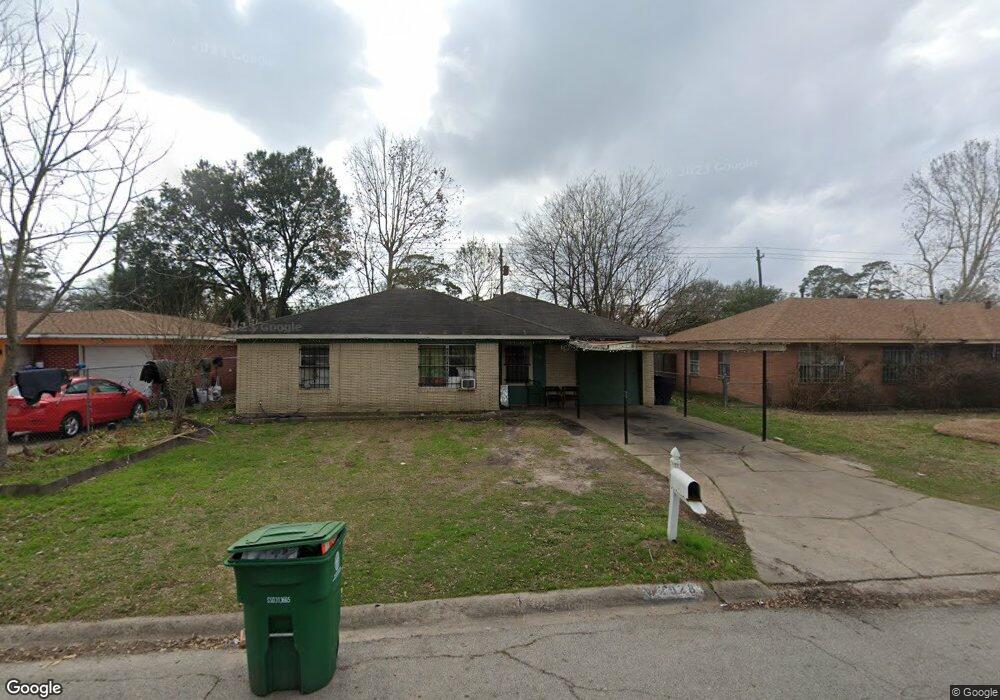
2928 Barksdale Dr Houston, TX 77093
Eastex-Jensen NeighborhoodEstimated Value: $163,078 - $182,000
2
Beds
1
Bath
1,149
Sq Ft
$148/Sq Ft
Est. Value
About This Home
This home is located at 2928 Barksdale Dr, Houston, TX 77093 and is currently estimated at $170,520, approximately $148 per square foot. 2928 Barksdale Dr is a home located in Harris County with nearby schools including Scarborough Elementary School, Patrick Henry Middle School, and Sam Houston Math, Science & Technology Center.
Ownership History
Date
Name
Owned For
Owner Type
Purchase Details
Closed on
Feb 16, 2016
Sold by
Mazal Properties
Bought by
Iniguez Carlos Jimenez and Menendez Alba M
Current Estimated Value
Purchase Details
Closed on
Jan 4, 2016
Sold by
Gonzalez Frances and Santos Nasario
Bought by
Mazal Properties
Create a Home Valuation Report for This Property
The Home Valuation Report is an in-depth analysis detailing your home's value as well as a comparison with similar homes in the area
Home Values in the Area
Average Home Value in this Area
Purchase History
| Date | Buyer | Sale Price | Title Company |
|---|---|---|---|
| Iniguez Carlos Jimenez | -- | None Available | |
| Mazal Properties | -- | None Available |
Source: Public Records
Mortgage History
| Date | Status | Borrower | Loan Amount |
|---|---|---|---|
| Closed | Iniguez Carlos Jimenez | $0 |
Source: Public Records
Tax History Compared to Growth
Tax History
| Year | Tax Paid | Tax Assessment Tax Assessment Total Assessment is a certain percentage of the fair market value that is determined by local assessors to be the total taxable value of land and additions on the property. | Land | Improvement |
|---|---|---|---|---|
| 2025 | $3,144 | $159,113 | $50,369 | $108,744 |
| 2024 | $3,144 | $150,257 | $41,513 | $108,744 |
| 2023 | $3,144 | $151,134 | $41,513 | $109,621 |
| 2022 | $3,002 | $136,331 | $27,675 | $108,656 |
| 2021 | $2,344 | $100,586 | $17,989 | $82,597 |
| 2020 | $2,304 | $95,161 | $17,989 | $77,172 |
| 2019 | $2,268 | $89,636 | $15,221 | $74,415 |
| 2018 | $1,617 | $63,898 | $15,221 | $48,677 |
| 2017 | $1,616 | $63,898 | $15,221 | $48,677 |
| 2016 | $1,480 | $58,514 | $15,221 | $43,293 |
| 2015 | -- | $58,514 | $15,221 | $43,293 |
| 2014 | -- | $70,500 | $15,221 | $55,279 |
Source: Public Records
Map
Nearby Homes
- 1904 Little York Rd
- 1728 Little York Rd
- 2636 Lone Oak Rd
- 2629 Kowis St
- 4918 Langley Rd
- 2817 Cromwell St
- 3418 Hopper Rd
- 3804 Cedar Hill Ln
- 2315 Langley Rd
- 2332 Margaret St
- 3214 Brea Crest St
- 2415 Goodloe St
- 2915 Brea Crest St
- 3202 Parker Rd
- 2311 Warwick Rd
- 2237 Cromwell St
- 2152 William Tell St
- 2122 Kowis St
- 4410 Shelton Rd
- 3111 Hartwick Rd
- 2924 Barksdale Dr
- 2932 Barksdale Dr
- 2920 Barksdale Dr
- 2936 Barksdale Dr
- 2927 Barksdale Dr
- 2923 Barksdale Dr
- 2916 Barksdale Dr
- 2940 Barksdale Dr
- 2931 Yorkwood St
- 2919 Barksdale Dr
- 2935 Barksdale Dr
- 2927 Yorkwood St
- 2935 Yorkwood St
- 2915 Barksdale Dr
- 2944 Barksdale Dr
- 2912 Barksdale Dr
- 2923 Yorkwood St
- 2939 Yorkwood St
- 2924 Trenton Rd
- 2928 Trenton Rd