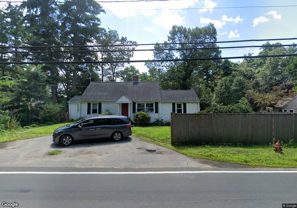
293 Hudson Rd Sudbury, MA 01776
Estimated Value: $596,000 - $707,000
2
Beds
1
Bath
1,332
Sq Ft
$492/Sq Ft
Est. Value
About This Home
This home is located at 293 Hudson Rd, Sudbury, MA 01776 and is currently estimated at $655,517, approximately $492 per square foot. 293 Hudson Rd is a home located in Middlesex County with nearby schools including General John Nixon Elementary School, Ephraim Curtis Middle School, and Lincoln-Sudbury Regional High School.
Ownership History
Date
Name
Owned For
Owner Type
Purchase Details
Closed on
Jan 29, 2009
Sold by
Fnma
Bought by
Mccain Danielle M and Stackpole Wayne C
Current Estimated Value
Purchase Details
Closed on
Jan 2, 2009
Sold by
Alum Donna
Bought by
Federal National Mortgage Association
Create a Home Valuation Report for This Property
The Home Valuation Report is an in-depth analysis detailing your home's value as well as a comparison with similar homes in the area
Home Values in the Area
Average Home Value in this Area
Purchase History
| Date | Buyer | Sale Price | Title Company |
|---|---|---|---|
| Mccain Danielle M | $268,500 | -- | |
| Federal National Mortgage Association | $293,728 | -- | |
| Mccain Danielle M | $268,500 | -- | |
| Federal National Mortgage Association | $293,728 | -- |
Source: Public Records
Mortgage History
| Date | Status | Borrower | Loan Amount |
|---|---|---|---|
| Open | Federal National Mortgage Association | $214,800 | |
| Previous Owner | Federal National Mortgage Association | $208,000 |
Source: Public Records
Tax History
| Year | Tax Paid | Tax Assessment Tax Assessment Total Assessment is a certain percentage of the fair market value that is determined by local assessors to be the total taxable value of land and additions on the property. | Land | Improvement |
|---|---|---|---|---|
| 2025 | $8,291 | $566,300 | $323,700 | $242,600 |
| 2024 | $8,009 | $548,200 | $314,200 | $234,000 |
| 2023 | $8,357 | $529,900 | $301,900 | $228,000 |
| 2022 | $8,099 | $448,700 | $277,100 | $171,600 |
| 2021 | $7,865 | $417,700 | $277,100 | $140,600 |
| 2020 | $7,707 | $417,700 | $277,100 | $140,600 |
| 2019 | $7,481 | $417,700 | $277,100 | $140,600 |
| 2018 | $7,159 | $399,300 | $268,600 | $130,700 |
| 2017 | $6,885 | $388,100 | $265,900 | $122,200 |
| 2016 | $6,627 | $372,300 | $255,700 | $116,600 |
| 2015 | $6,311 | $358,600 | $243,400 | $115,200 |
| 2014 | $6,287 | $348,700 | $236,300 | $112,400 |
Source: Public Records
Map
Nearby Homes
- 62 Churchill St
- 11 October Rd
- 45 Webster Cir
- 557 Dutton Rd Unit 2
- 8 Twillingate Rd
- 30 Harness Ln
- 25 Poplar St
- 55 Widow Rites Ln
- 45 Widow Rites Ln
- 111 Willis Rd
- 355 Maynard Rd
- 15 Huckleberry Ln
- 11 Great Lake Dr
- 30 Kendall Rd
- 6 Canterbury Dr
- 53 Pine St
- 30 Rolling Ln
- 427 Concord Rd
- 25 Plantation Cir
- 46 Brewster Rd
- 1 Lillian Ave
- 7 Richard Ave
- 7 Richard Ave
- 10 Richard Ave
- 10 Richard Ave Unit SF
- 9 Lillian Ave
- 2 Lillian Ave
- 4 Country Village Ln
- 3 Country Village Ln
- 286 Hudson Rd
- 14 Richard Ave
- 301 Hudson Rd
- 16 Richard Ave
- 16 Richard Ave Unit 16
- 16 Richard Ave
- 15 Richard Ave
- 12 Lillian Ave
- 15 Lillian Ave
- 41 Stubtoe Ln
- 18 Richard Ave
Your Personal Tour Guide
Ask me questions while you tour the home.