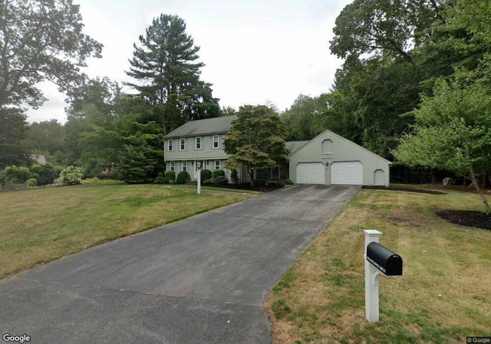
293 Mayflower Cir Hanover, MA 02339
Estimated Value: $952,131 - $1,353,000
4
Beds
3
Baths
2,540
Sq Ft
$445/Sq Ft
Est. Value
About This Home
This home is located at 293 Mayflower Cir, Hanover, MA 02339 and is currently estimated at $1,129,033, approximately $444 per square foot. 293 Mayflower Cir is a home located in Plymouth County with nearby schools including Hanover High School, The Master's Academy, and Cardinal Cushing Centers.
Ownership History
Date
Name
Owned For
Owner Type
Purchase Details
Closed on
Sep 20, 2016
Sold by
Mack Edward A and Mack Carol T
Bought by
Mack Ret
Current Estimated Value
Purchase Details
Closed on
Jun 28, 1996
Sold by
Massa Ernest A and Massa Joanne
Bought by
Mack Edward A and Mack Carol T
Home Financials for this Owner
Home Financials are based on the most recent Mortgage that was taken out on this home.
Original Mortgage
$128,000
Interest Rate
8.05%
Mortgage Type
Purchase Money Mortgage
Create a Home Valuation Report for This Property
The Home Valuation Report is an in-depth analysis detailing your home's value as well as a comparison with similar homes in the area
Home Values in the Area
Average Home Value in this Area
Purchase History
| Date | Buyer | Sale Price | Title Company |
|---|---|---|---|
| Mack Ret | -- | -- | |
| Mack Edward A | $310,000 | -- |
Source: Public Records
Mortgage History
| Date | Status | Borrower | Loan Amount |
|---|---|---|---|
| Previous Owner | Mack Edward A | $114,000 | |
| Previous Owner | Mack Edward A | $16,623 | |
| Previous Owner | Mack Edward A | $128,000 |
Source: Public Records
Tax History
| Year | Tax Paid | Tax Assessment Tax Assessment Total Assessment is a certain percentage of the fair market value that is determined by local assessors to be the total taxable value of land and additions on the property. | Land | Improvement |
|---|---|---|---|---|
| 2025 | $10,838 | $877,600 | $335,900 | $541,700 |
| 2024 | $10,596 | $825,200 | $335,900 | $489,300 |
| 2023 | $10,147 | $752,200 | $305,600 | $446,600 |
| 2022 | $9,909 | $649,800 | $254,700 | $395,100 |
| 2021 | $5,031 | $602,000 | $231,600 | $370,400 |
| 2020 | $9,554 | $585,800 | $231,600 | $354,200 |
| 2019 | $9,239 | $563,000 | $231,600 | $331,400 |
| 2018 | $8,640 | $530,700 | $231,600 | $299,100 |
| 2017 | $8,835 | $534,800 | $237,000 | $297,800 |
| 2016 | $8,540 | $506,500 | $215,400 | $291,100 |
| 2015 | $8,497 | $526,100 | $235,000 | $291,100 |
Source: Public Records
Map
Nearby Homes
- 62 Larchmont Ln
- 506 Main St
- 36 Grove St
- 250 Center St
- 51 Cervelli Farm Dr
- 37 Dr
- 23 Cervelli Farm Dr
- 38 Cervelli Farm Dr
- 9 Cervelli Farm Dr
- 561 Circuit St
- 75 School St
- 776 Main St
- 95 Tecumseh Dr
- 44 Stone Meadow Ln
- 47 Stone Meadow Ln
- 53 Chestnut St
- 33 1st Parish Ln
- 36 Bayberry Ln
- 35 Sproul Rd
- 823 Market St
- 309 Mayflower Cir
- 283 Mayflower Cir
- 298 Mayflower Cir
- 321 Mayflower Cir
- 286 Mayflower Cir
- 320 Mayflower Cir
- 331 Mayflower Cir
- 142 Colonial Dr
- 130 Colonial Dr
- 332 Mayflower Cir
- 345 Mayflower Cir
- 152 Colonial Dr
- 344 Mayflower Cir
- 174 Colonial Dr
- 82 Colonial Dr
- 131 Colonial Dr
- 141 Colonial Dr
- 352 Mayflower Cir
- 5 Briscos Plain
- 355 Mayflower Cir
Your Personal Tour Guide
Ask me questions while you tour the home.