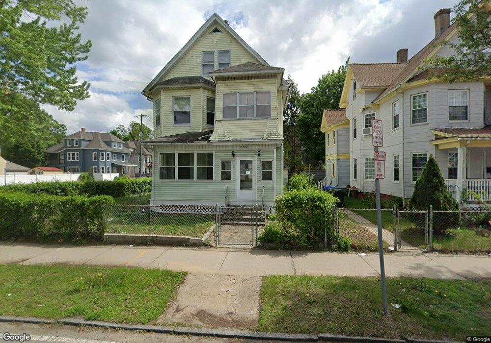
293 Wilbraham Rd Springfield, MA 01109
Upper Hill NeighborhoodEstimated Value: $298,537 - $335,000
About This Home
This home is located at 293 Wilbraham Rd, Springfield, MA 01109 and is currently estimated at $315,384, approximately $95 per square foot. 293 Wilbraham Rd is a home located in Hampden County with nearby schools including Homer Street Elementary School, John J Duggan Middle, and Springfield High School of Science and Technology.
Ownership History
We collect this data history from publicly available records. To have your information removed, we recommend requesting removal directly through your county’s website.
Purchase Details
Home Values in the Area
Average Home Value in this Area
Purchase History
We collect this data history from publicly available records. To have your information removed, we recommend requesting removal directly through your county’s website.
| Date | Buyer | Sale Price | Title Company |
|---|---|---|---|
| -- | -- |
Tax History
We collect this data history from publicly available records. To have your information removed, we recommend requesting removal directly through your county’s website.
| Year | Tax Paid | Tax Assessment Tax Assessment Total Assessment is a certain percentage of the fair market value that is determined by local assessors to be the total taxable value of land and additions on the property. | Land | Improvement |
|---|---|---|---|---|
| 2025 | $3,682 | $234,800 | $30,000 | $204,800 |
| 2024 | $3,058 | $190,400 | $30,000 | $160,400 |
| 2023 | $2,808 | $164,700 | $27,200 | $137,500 |
| 2022 | $3,350 | $178,000 | $25,500 | $152,500 |
| 2021 | $3,101 | $164,100 | $18,100 | $146,000 |
| 2020 | $2,890 | $148,000 | $18,100 | $129,900 |
| 2019 | $2,751 | $139,800 | $15,400 | $124,400 |
| 2018 | $2,635 | $133,900 | $15,400 | $118,500 |
| 2017 | $2,505 | $127,400 | $14,500 | $112,900 |
| 2016 | $2,153 | $109,500 | $14,500 | $95,000 |
| 2015 | $2,118 | $107,700 | $14,500 | $93,200 |
Map
- 119-121 Middlesex St
- 59-61 Carlisle St
- 26 Byron St
- 135-137 Albemarle St
- 46 Mapledell St
- 21 Westford Cir
- 881 Roosevelt Ave
- 115-117 Northampton Ave
- 65 Montrose St
- 136 Maynard St
- 49 Andrew St
- 181-183 Northampton Ave
- 746-748 Alden St
- 62 Kenyon St
- 90 Andrew St
- 102-104 Cambridge St
- 199 Eastern Ave
- 229 Quincy St
- 412 Island Pond Rd
- 25 Dawes St
- 17-19 Middlesex St
- 17 Middlesex St Unit 19
- 15 Middlesex St
- 23 Middlesex St
- 31 Middlesex St
- 301 Wilbraham Rd
- 18-20 Middlesex St
- 26 Suffolk St
- 18 Middlesex St Unit 20
- 24 Middlesex St
- 14 Middlesex St
- 35 Middlesex St
- 309 Wilbraham Rd
- 30 Middlesex St
- 36 Suffolk St Unit 38
- 36-38 Suffolk St
- 41 Middlesex St
- 289 Wilbraham Rd
- 36 Middlesex St
- 42-44 Suffolk St
Ask me questions while you tour the home.