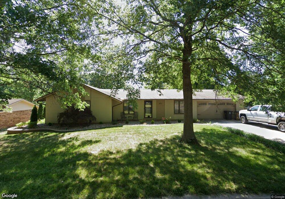
2933 La Mesa St Cape Girardeau, MO 63701
Estimated Value: $284,453 - $334,000
3
Beds
3
Baths
2,210
Sq Ft
$140/Sq Ft
Est. Value
About This Home
This home is located at 2933 La Mesa St, Cape Girardeau, MO 63701 and is currently estimated at $308,363, approximately $139 per square foot. 2933 La Mesa St is a home located in Cape Girardeau County with nearby schools including Alma Schrader Elementary School, Central Middle School, and Central Junior High School.
Ownership History
Date
Name
Owned For
Owner Type
Purchase Details
Closed on
Aug 11, 2016
Sold by
Wells Craig and Wells Mona
Bought by
Wells Fargo Bank Trust
Current Estimated Value
Purchase Details
Closed on
Jun 30, 2010
Sold by
Martin Gilbert E and Martin Patricia S
Bought by
Wells Craig Ellsworth and Wells Mona Lea
Home Financials for this Owner
Home Financials are based on the most recent Mortgage that was taken out on this home.
Original Mortgage
$105,000
Interest Rate
4.78%
Mortgage Type
New Conventional
Create a Home Valuation Report for This Property
The Home Valuation Report is an in-depth analysis detailing your home's value as well as a comparison with similar homes in the area
Home Values in the Area
Average Home Value in this Area
Purchase History
| Date | Buyer | Sale Price | Title Company |
|---|---|---|---|
| Wells Fargo Bank Trust | -- | -- | |
| Wells Craig Ellsworth | -- | None Available |
Source: Public Records
Mortgage History
| Date | Status | Borrower | Loan Amount |
|---|---|---|---|
| Previous Owner | Wells Craig Ellsworth | $105,000 |
Source: Public Records
Tax History Compared to Growth
Tax History
| Year | Tax Paid | Tax Assessment Tax Assessment Total Assessment is a certain percentage of the fair market value that is determined by local assessors to be the total taxable value of land and additions on the property. | Land | Improvement |
|---|---|---|---|---|
| 2025 | $16 | $32,440 | $3,790 | $28,650 |
| 2024 | $16 | $30,890 | $3,610 | $27,280 |
| 2023 | $1,605 | $30,890 | $3,610 | $27,280 |
| 2022 | $1,481 | $28,480 | $3,330 | $25,150 |
| 2021 | $1,481 | $28,480 | $3,330 | $25,150 |
| 2020 | $1,485 | $28,480 | $3,330 | $25,150 |
| 2019 | $1,482 | $28,470 | $0 | $0 |
| 2018 | $1,479 | $28,470 | $0 | $0 |
| 2017 | $1,483 | $28,470 | $0 | $0 |
| 2016 | $1,477 | $28,470 | $0 | $0 |
| 2015 | $1,478 | $28,470 | $0 | $0 |
| 2014 | $1,486 | $28,470 | $0 | $0 |
Source: Public Records
Map
Nearby Homes
- 2085 Derbyshire Ln
- 2206 Derbyshire Ln
- 2415 Perryville Rd
- 2528 Palomino Dr
- 2519 Horseshoe Ridge
- 2520 Horseshoe Ridge
- 2213 Crown Point Dr
- 2062 Concord Place
- 7 Turtle Ln
- 2137 Wood Hollow Ct
- 1910 Sherwood Dr
- 1577 Saratoga St
- 1553 Valley Forge Ln
- 1623 Lexington Ave
- 1960 Briarwood Dr
- 1608 Lexington Ave
- 190 Paiute Ln
- 1572 Lexington Ave
- 164 Waller Ln
- 2224 Heywood Meadows
- 2929 La Mesa Dr
- 2932 La Mesa Dr
- 1828 La Mesa Dr
- 2925 La Mesa Dr
- 2928 La Mesa Dr
- 2928 La Mesa St
- 1824 La Mesa Dr
- 2932 Perryville Rd
- 2924 La Mesa Dr
- 2921 La Mesa Dr
- 2928 Perryville Rd
- 1820 La Mesa Dr
- 2933 Alta Cuesta Dr
- 2920 Perryville Rd
- 2920 La Mesa Dr
- 2929 Alta Cuesta Dr
- 2920 La Mesa St
- 1816 La Mesa Dr
- 2917 La Mesa Dr
- 2925 Cuesta Dr