
Landlord's Agent in 2025
Questa Locke
Berkshire Hathaway HomeServices Alaska Realty
(907) 865-6500
3 in this area
56 Total Sales

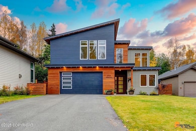
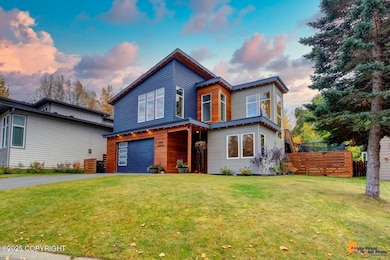


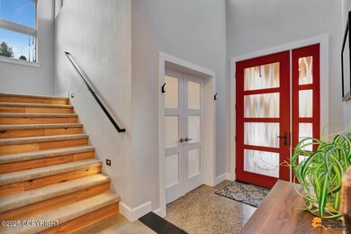

Luxury Turnagain Rental - Fully Furnished & Thousands Less Than a Mortgage!Live in one of Anchorage's most sought-after neighborhoods with this beautifully furnished luxury home, available for long-term lease. Located just steps from the Coastal Trail and within walking distance to restaurants, schools, and parks.This upgraded residence features vaulted ceilings, elegant wood flooring,The home is furnished with:
Primary bedroom: King bed
Two guest bedrooms: Queen beds
One bedroom set up as a dedicated office
Lease Terms:
Tenant pays: Gas, Electric, Yard Maintenance, Snow Removal, Internet
Owner pays: Water/Sewer
12-month lease preferred
Don't miss this rare opportunity to enjoy luxury, comfort, and convenienceat a fraction of the cost of ownership.
Last Agent to Rent the Property
Berkshire Hathaway HomeServices Alaska Realty License #15590 Listed on: 06/09/2025
| Date | Buyer | Sale Price | Title Company |
|---|---|---|---|
| Woodland William A | -- | None Available |
| Date | Status | Borrower | Loan Amount |
|---|---|---|---|
| Open | Woodland William A | $718,466 |
| Date | Event | Price | Change | Sq Ft Price |
|---|---|---|---|---|
| 08/04/2025 08/04/25 | Rented | $6,500 | 0.0% | -- |
| 06/26/2025 06/26/25 | Price Changed | $6,500 | -7.1% | $2 / Sq Ft |
| 06/16/2025 06/16/25 | For Rent | $7,000 | -- | -- |
| Year | Tax Paid | Tax Assessment Tax Assessment Total Assessment is a certain percentage of the fair market value that is determined by local assessors to be the total taxable value of land and additions on the property. | Land | Improvement |
|---|---|---|---|---|
| 2025 | $12,020 | $776,600 | $205,200 | $571,400 |
| 2024 | $12,020 | $744,500 | $192,200 | $552,300 |
| 2023 | $11,873 | $697,200 | $192,200 | $505,000 |
| 2022 | $11,704 | $695,000 | $192,100 | $502,900 |
| 2021 | $11,509 | $638,700 | $192,100 | $446,600 |
| 2020 | $10,627 | $625,100 | $192,100 | $433,000 |
| 2019 | $10,268 | $627,600 | $192,100 | $435,500 |
| 2018 | $3,252 | $198,300 | $172,100 | $26,200 |
| 2017 | $2,695 | $172,100 | $172,100 | $0 |
| 2016 | $2,832 | $161,700 | $161,700 | $0 |
| 2015 | $2,832 | $161,700 | $161,700 | $0 |
| 2014 | $2,832 | $161,700 | $161,700 | $0 |
Landlord's Agent in 2025
Questa Locke
Berkshire Hathaway HomeServices Alaska Realty
(907) 865-6500
3 in this area
56 Total Sales
Source: Alaska Multiple Listing Service
MLS Number: 25-7291
APN: 00113223000
Disclaimer: Certain information contained herein is derived from information provided by parties other than Homes.com. All information provided is deemed reliable, but is not guaranteed to be accurate and should be independently verified.
![]() The listing content relating to real estate for sale on this web site comes in part from the IDX Program of Alaska Multiple Listing Service, Inc. (AK MLS). Real estate listings held by brokerage firms other than Ten-X are marked with either the listing brokerage’s logo or the AK MLS logo and information about them includes the name of the listing brokerage. All information is deemed reliable but is not guaranteed and should be independently verified for accuracy. Copyright 2025 Alaska Multiple Listing Service, Inc. All rights reserved.
The listing content relating to real estate for sale on this web site comes in part from the IDX Program of Alaska Multiple Listing Service, Inc. (AK MLS). Real estate listings held by brokerage firms other than Ten-X are marked with either the listing brokerage’s logo or the AK MLS logo and information about them includes the name of the listing brokerage. All information is deemed reliable but is not guaranteed and should be independently verified for accuracy. Copyright 2025 Alaska Multiple Listing Service, Inc. All rights reserved.