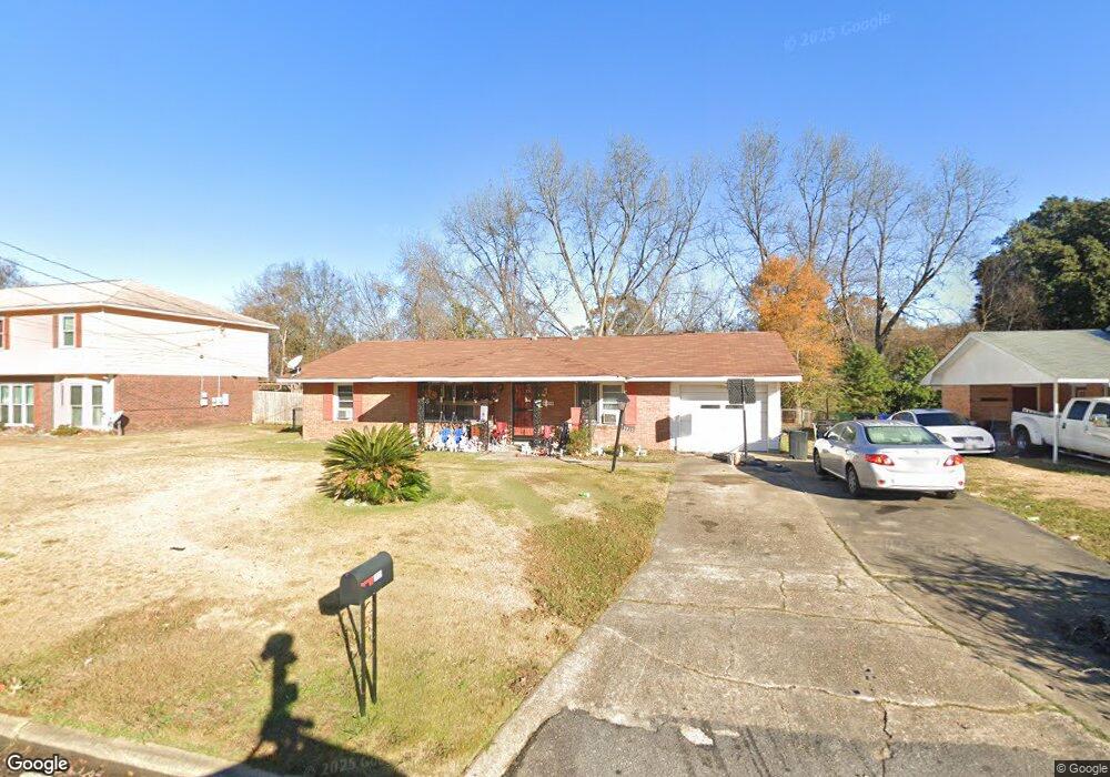
2935 Avondale Rd Columbus, GA 31903
Southern Columbus NeighborhoodEstimated Value: $88,000 - $120,205
3
Beds
3
Baths
1,305
Sq Ft
$85/Sq Ft
Est. Value
About This Home
This home is located at 2935 Avondale Rd, Columbus, GA 31903 and is currently estimated at $110,801, approximately $84 per square foot. 2935 Avondale Rd is a home located in Muscogee County with nearby schools including South Columbus Elementary School, Eddy Middle School, and Spencer High School.
Ownership History
Date
Name
Owned For
Owner Type
Purchase Details
Closed on
Mar 7, 2018
Sold by
Baker Carolyn
Bought by
Baker Carolyn and Monk Christy Lynn
Current Estimated Value
Purchase Details
Closed on
Jun 4, 2009
Sold by
Westervelt Imogene L
Bought by
Baker Jesse and Baker Carolyn
Purchase Details
Closed on
Jun 8, 2007
Sold by
Westervelt Imogene L
Bought by
Westervelt Imogene L
Create a Home Valuation Report for This Property
The Home Valuation Report is an in-depth analysis detailing your home's value as well as a comparison with similar homes in the area
Home Values in the Area
Average Home Value in this Area
Purchase History
| Date | Buyer | Sale Price | Title Company |
|---|---|---|---|
| Baker Carolyn | -- | -- | |
| Baker Jesse | $92,000 | None Available | |
| Westervelt Imogene L | -- | None Available |
Source: Public Records
Tax History Compared to Growth
Tax History
| Year | Tax Paid | Tax Assessment Tax Assessment Total Assessment is a certain percentage of the fair market value that is determined by local assessors to be the total taxable value of land and additions on the property. | Land | Improvement |
|---|---|---|---|---|
| 2025 | $1,058 | $34,836 | $4,344 | $30,492 |
| 2024 | $1,057 | $34,836 | $4,344 | $30,492 |
| 2023 | $369 | $34,836 | $4,344 | $30,492 |
| 2022 | $1,102 | $28,424 | $4,344 | $24,080 |
| 2021 | $1,095 | $30,768 | $4,344 | $26,424 |
| 2020 | $1,095 | $30,768 | $4,344 | $26,424 |
| 2019 | $1,100 | $30,768 | $4,344 | $26,424 |
| 2018 | $1,100 | $30,768 | $4,344 | $26,424 |
| 2017 | $1,107 | $30,768 | $4,344 | $26,424 |
| 2016 | $1,111 | $40,204 | $3,680 | $36,524 |
| 2015 | $1,111 | $40,204 | $3,680 | $36,524 |
| 2014 | $1,111 | $40,204 | $3,680 | $36,524 |
| 2013 | -- | $40,204 | $3,680 | $36,524 |
Source: Public Records
Map
Nearby Homes
- 3009 Plantation Rd
- 2973 Hawthorne Dr
- 2451 Brownie Ln
- 1274 Providence Ln
- 2463 Brownie Ln
- 2102 Somerset Ave
- 3042 Colonial Dr
- 2463 Brownie St
- 3015 Hendrix St
- 2203 Simmons Ave
- 2333 Bruce Ave
- 3135 Baker Cir
- 2309 Ginny Ave
- 2404 Bruce Ave
- 3110 Victory Dr
- 3310 Albert St
- 2425 Howe Ave
- 1029 Harbison Dr
- 2313 Dorothy Ave
- 2417 Manning Ave
- 2931 Avondale Rd
- 2939 Avondale Rd
- 2858 Ramsey Rd
- 2864 Ramsey Rd
- 2941 Avondale Rd
- 2929 Avondale Rd
- 2852 Ramsey Rd
- 2870 Ramsey Rd
- 2938 Avondale Rd
- 2934 Avondale Rd
- 2848 Ramsey Rd
- 2942 Avondale Rd
- 0 Avondale Rd Unit 8005522
- 2874 Ramsey Rd
- 2945 Avondale Rd
- 2925 Avondale Rd
- 2930 Avondale Rd
- 2880 Ramsey Rd
- 2950 Avondale Rd
- 2926 Avondale Rd