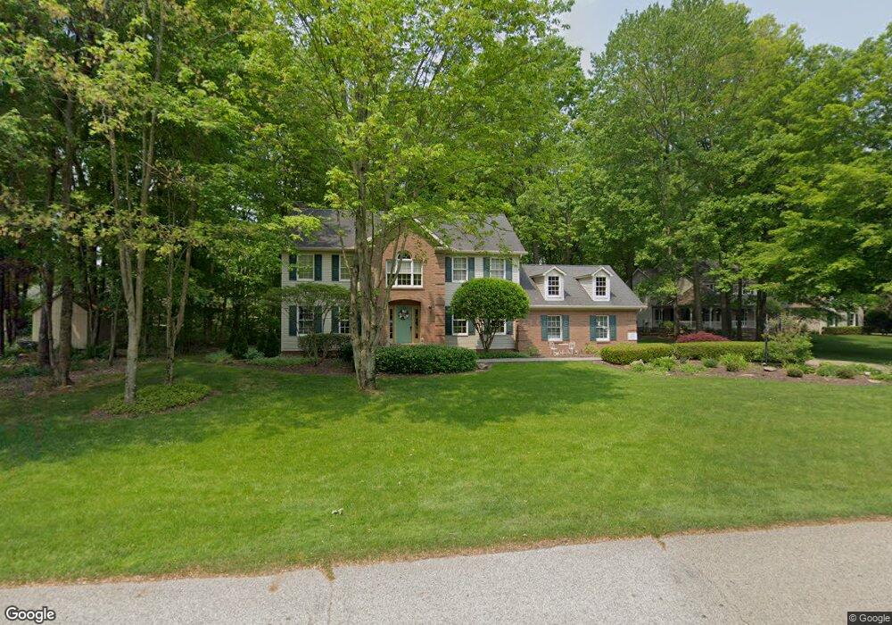
2935 Crown Point Cortland, OH 44410
Estimated Value: $406,356 - $449,000
4
Beds
3
Baths
2,630
Sq Ft
$164/Sq Ft
Est. Value
About This Home
This home is located at 2935 Crown Point, Cortland, OH 44410 and is currently estimated at $431,089, approximately $163 per square foot. 2935 Crown Point is a home located in Trumbull County with nearby schools including Lakeview Elementary School, Lakeview Middle School, and Lakeview High School.
Ownership History
Date
Name
Owned For
Owner Type
Purchase Details
Closed on
Mar 31, 1997
Sold by
Varady Wayne E
Bought by
Black Frederick and Black Diane L
Current Estimated Value
Home Financials for this Owner
Home Financials are based on the most recent Mortgage that was taken out on this home.
Original Mortgage
$179,200
Interest Rate
7.73%
Mortgage Type
New Conventional
Purchase Details
Closed on
Jan 1, 1990
Bought by
Wayne E Varady
Create a Home Valuation Report for This Property
The Home Valuation Report is an in-depth analysis detailing your home's value as well as a comparison with similar homes in the area
Home Values in the Area
Average Home Value in this Area
Purchase History
| Date | Buyer | Sale Price | Title Company |
|---|---|---|---|
| Black Frederick | $224,000 | -- | |
| Wayne E Varady | -- | -- |
Source: Public Records
Mortgage History
| Date | Status | Borrower | Loan Amount |
|---|---|---|---|
| Closed | Black Frederick | $179,200 |
Source: Public Records
Tax History Compared to Growth
Tax History
| Year | Tax Paid | Tax Assessment Tax Assessment Total Assessment is a certain percentage of the fair market value that is determined by local assessors to be the total taxable value of land and additions on the property. | Land | Improvement |
|---|---|---|---|---|
| 2024 | $5,551 | $121,420 | $19,530 | $101,890 |
| 2023 | $5,551 | $121,420 | $19,530 | $101,890 |
| 2022 | $4,353 | $85,470 | $13,650 | $71,820 |
| 2021 | $4,369 | $85,470 | $13,650 | $71,820 |
| 2020 | $4,382 | $85,470 | $13,650 | $71,820 |
| 2019 | $4,094 | $77,770 | $13,650 | $64,120 |
| 2018 | $4,114 | $77,770 | $13,650 | $64,120 |
| 2017 | $4,105 | $77,770 | $13,650 | $64,120 |
| 2016 | $3,886 | $72,390 | $12,080 | $60,310 |
| 2015 | $3,924 | $72,390 | $12,080 | $60,310 |
| 2014 | $3,600 | $72,390 | $12,080 | $60,310 |
| 2013 | $3,667 | $72,390 | $12,080 | $60,310 |
Source: Public Records
Map
Nearby Homes
- 2760 Ravine Run
- 2271 Saddlebrook Ln
- 3258 Woodland Trail Unit B
- 3248 Woodland Trail
- 3093 Ivy Hill Cir Unit D
- 3063 Ivy Hill Cir Unit D
- 0 Niles Ashtabula Rd Unit 5147189
- 3012 Ivy Hill Cir
- 3476 Ivy Hill Cir Unit D
- 3262 Pheasant Run Rd Unit B
- 3438 Warren Meadville Rd
- 3233 Niles Cortland Rd NE
- 2609 Warren Meadville Rd
- 3454 Warren Meadville Rd
- 2495 Wilshire Dr
- 0 Durst Dr
- 0 Niles Cortland Rd NE Unit 5146227
- 2730 Wilson Sharpsville Rd
- 220 Wae Trail
- 229 Greenbriar Dr
- 2949 Crown Point
- 2915 Crown Point
- 2918 Beaver Trail
- 2932 Beaver Trail
- 2938 Crown Point
- 2928 Crown Point
- 2950 Crown Point
- 2951 Crown Point
- 2916 Crown Point
- 2958 Crown Point
- 2888 Beaver Trail
- 2923 Beaver Trail
- 2891 Timber Creek Dr N
- 2933 Beaver Trail
- 2992 Fallehn Dr
- 2982 Fallehn Dr
- 2972 Fallehn Dr
- 3008 Fallehn Dr
- 2962 Fallehn Dr
- 3016 Fallehn Dr