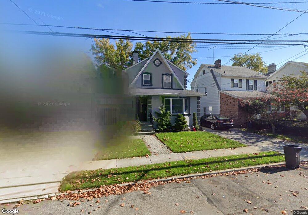
2937 212th St Bayside, NY 11360
Bayside NeighborhoodEstimated Value: $1,006,000 - $1,239,000
Studio
--
Bath
1,202
Sq Ft
$903/Sq Ft
Est. Value
About This Home
This home is located at 2937 212th St, Bayside, NY 11360 and is currently estimated at $1,085,358, approximately $902 per square foot. 2937 212th St is a home located in Queens County with nearby schools including P.S. 41 - Crocheron, M.S. 158 - Marie Curie, and Bayside High School.
Ownership History
Date
Name
Owned For
Owner Type
Purchase Details
Closed on
Jun 3, 2019
Sold by
Ross Keit
Bought by
Foo Ashley and Foo Dwayne
Current Estimated Value
Home Financials for this Owner
Home Financials are based on the most recent Mortgage that was taken out on this home.
Original Mortgage
$775,000
Outstanding Balance
$680,033
Interest Rate
4%
Mortgage Type
Unknown
Estimated Equity
$405,325
Purchase Details
Closed on
Aug 28, 2018
Sold by
Keit Gordon and Keit Helen
Bought by
Ross Keit
Purchase Details
Closed on
Oct 7, 2010
Sold by
Guido Deceased Delia Frances
Bought by
G H Keit Realty Llc
Create a Home Valuation Report for This Property
The Home Valuation Report is an in-depth analysis detailing your home's value as well as a comparison with similar homes in the area
Home Values in the Area
Average Home Value in this Area
Purchase History
| Date | Buyer | Sale Price | Title Company |
|---|---|---|---|
| Foo Ashley | $975,000 | -- | |
| Keit Ross | -- | -- | |
| Ross Keit | -- | -- | |
| Keit Gordon | -- | -- | |
| G H Keit Realty Llc | $625,000 | -- |
Source: Public Records
Mortgage History
| Date | Status | Borrower | Loan Amount |
|---|---|---|---|
| Open | Foo Ashley | $775,000 |
Source: Public Records
Tax History
| Year | Tax Paid | Tax Assessment Tax Assessment Total Assessment is a certain percentage of the fair market value that is determined by local assessors to be the total taxable value of land and additions on the property. | Land | Improvement |
|---|---|---|---|---|
| 2025 | $8,969 | $45,664 | $12,272 | $33,392 |
| 2024 | $7,572 | $44,657 | $12,975 | $31,682 |
| 2023 | $8,472 | $42,181 | $12,256 | $29,925 |
| 2022 | $7,944 | $48,660 | $16,980 | $31,680 |
| 2021 | $8,013 | $52,080 | $16,980 | $35,100 |
| 2020 | $8,055 | $51,060 | $16,980 | $34,080 |
| 2019 | $7,785 | $51,360 | $16,980 | $34,380 |
Source: Public Records
Map
Nearby Homes
- 2930 Bell Blvd
- 29-30 Bell Blvd
- 2914 Bell Blvd
- 210-30 29th Ave
- 32-37 214th St
- 2901 Bell Blvd
- 33-03 213th St
- 28-18 211th St Unit 5A
- 2835 Bell Blvd
- 2830 210th St
- 209-25 28th Ave
- 34-08 210th St
- 211-22 34th Rd
- 2803 215th St
- 21019 26th Ave Unit TL
- 32-12 208th St
- 214-43 27th Ave
- 33-15 208th St
- 209-33 26th Ave Unit TJ
- 20933 26th Ave Unit 2B
- 2941 212th St
- 29-33 212 St
- 2933 212th St
- 29-33 212th St
- 29-33 212th St Unit 1F
- 29-33 212th St Unit 2
- 29-33 212th St Unit 2FL
- 29-33 212th St Unit 1FL+Ba
- 29-33-2212 212th St
- 21205 32nd Ave
- 2940 213th St
- 2936 213th St
- 2927 212th St
- 21215 32nd Ave
- 2932 213th St
- 29-32 213th St Unit 1st Fl
- 2932 213th St
- 29-32 213th St
- 2940 212th St
- 2934 212th St
Your Personal Tour Guide
Ask me questions while you tour the home.