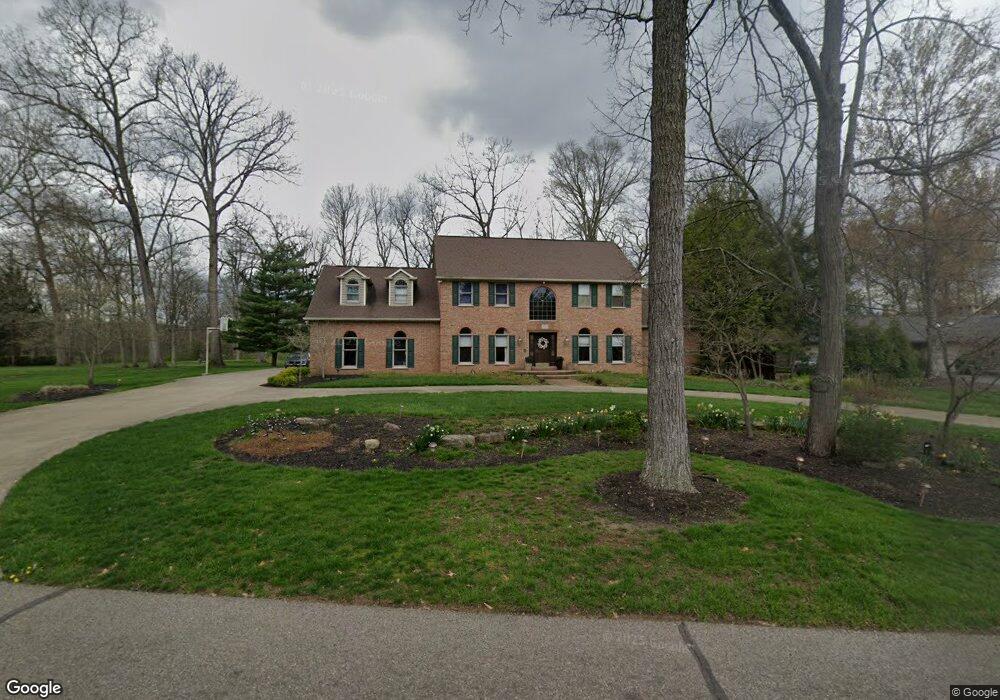
2939 West Dr Zanesville, OH 43701
Estimated Value: $610,000 - $896,585
4
Beds
5
Baths
4,228
Sq Ft
$173/Sq Ft
Est. Value
About This Home
This home is located at 2939 West Dr, Zanesville, OH 43701 and is currently estimated at $731,896, approximately $173 per square foot. 2939 West Dr is a home located in Muskingum County with nearby schools including John McIntire Elementary School, Zanesville Middle School, and Zanesville High School.
Ownership History
Date
Name
Owned For
Owner Type
Purchase Details
Closed on
Oct 1, 2024
Sold by
Wegner Scott A and Wegner Nicole D
Bought by
Wegner Scott A and Wegner Nicole D
Current Estimated Value
Purchase Details
Closed on
Jun 21, 2010
Sold by
Nist Ellen G
Bought by
Wegner Scott A and Wegner Nicole D
Home Financials for this Owner
Home Financials are based on the most recent Mortgage that was taken out on this home.
Original Mortgage
$555,100
Interest Rate
5.75%
Mortgage Type
New Conventional
Purchase Details
Closed on
May 24, 2001
Sold by
Wade Larry L
Bought by
Nist Robert A and Nist Ellen
Home Financials for this Owner
Home Financials are based on the most recent Mortgage that was taken out on this home.
Original Mortgage
$559,000
Interest Rate
7.07%
Mortgage Type
New Conventional
Create a Home Valuation Report for This Property
The Home Valuation Report is an in-depth analysis detailing your home's value as well as a comparison with similar homes in the area
Home Values in the Area
Average Home Value in this Area
Purchase History
| Date | Buyer | Sale Price | Title Company |
|---|---|---|---|
| Wegner Scott A | -- | None Listed On Document | |
| Wegner Scott A | $693,900 | Attorney | |
| Nist Robert A | $699,000 | -- |
Source: Public Records
Mortgage History
| Date | Status | Borrower | Loan Amount |
|---|---|---|---|
| Previous Owner | Wegner Scott A | $555,100 | |
| Previous Owner | Nist Robert A | $559,000 |
Source: Public Records
Tax History Compared to Growth
Tax History
| Year | Tax Paid | Tax Assessment Tax Assessment Total Assessment is a certain percentage of the fair market value that is determined by local assessors to be the total taxable value of land and additions on the property. | Land | Improvement |
|---|---|---|---|---|
| 2024 | $9,718 | $268,065 | $23,625 | $244,440 |
| 2023 | $8,170 | $210,980 | $25,480 | $185,500 |
| 2022 | $8,001 | $210,980 | $25,480 | $185,500 |
| 2021 | $7,930 | $210,980 | $25,480 | $185,500 |
| 2020 | $7,749 | $200,935 | $24,255 | $176,680 |
| 2019 | $7,747 | $200,935 | $24,255 | $176,680 |
| 2018 | $7,861 | $200,935 | $24,255 | $176,680 |
| 2017 | $7,384 | $181,405 | $24,255 | $157,150 |
| 2016 | $7,492 | $181,410 | $24,260 | $157,150 |
| 2015 | $7,513 | $181,410 | $24,260 | $157,150 |
| 2013 | $8,317 | $181,410 | $24,260 | $157,150 |
Source: Public Records
Map
Nearby Homes
- 2809 West Dr
- 2370 Oak Meadow Ln
- 1035 Somers St
- 0 Leonard Ave Unit 4200634
- 830 Bethesda Dr Unit 4
- 835 Princeton Ave
- 1570 Nob Hill Rd
- 801 Leonard Ave
- 1208 Brandywine Blvd
- 2411 Bell St
- 765 Wabash Ave
- 753 Leonard Ave
- 1700 Newark Rd
- 875 Orchard Hill Rd
- 2015 Dunzweiler Dr
- 2036 Marion Ave
- 0 W Ray Dr
- 36C W Ray Dr
- 1106 S Slope Bay
- 0 W Ray- 36c Dr
- 2747 West Dr
- 2942 West Dr
- 2771 West Dr
- 2932 West Dr
- 2913 West Dr
- 2962 West Dr
- 2793 West Dr
- 2900 West Dr
- 2770 West Dr
- 3011 West Dr
- 2796 West Dr
- 0 East Dr Unit 4021936
- 0 East Dr Unit 4021926
- 0 East Dr Unit 3974095
- 0 East Dr Unit 218027748
- 0 East Dr Unit 218027749
- 3012 West Dr
- 2891 Center Dr
- 2915 Center Dr
- 2687 Carol Dr