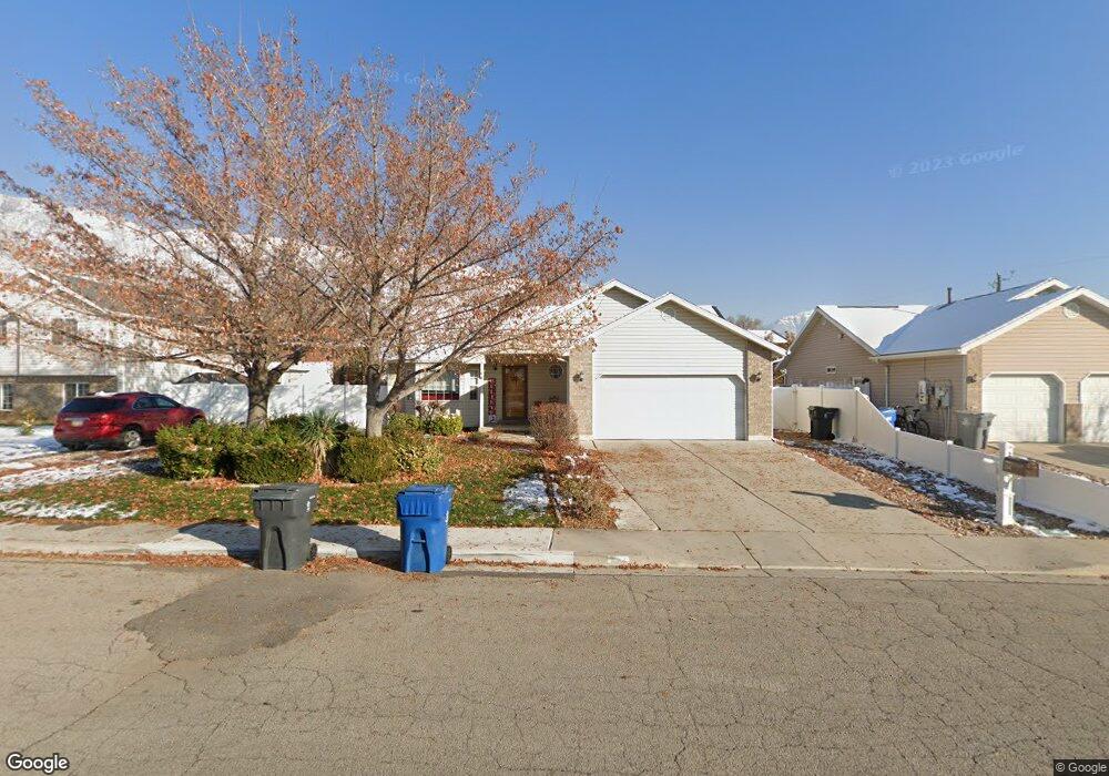
294 Allenhurst Pleasant Grove, UT 84062
Estimated Value: $480,000 - $584,000
3
Beds
3
Baths
1,193
Sq Ft
$448/Sq Ft
Est. Value
About This Home
This home is located at 294 Allenhurst, Pleasant Grove, UT 84062 and is currently estimated at $534,070, approximately $447 per square foot. 294 Allenhurst is a home located in Utah County with nearby schools including Central Elementary School, Pleasant Grove Junior High School, and Pleasant Grove High School.
Ownership History
Date
Name
Owned For
Owner Type
Purchase Details
Closed on
Aug 30, 2017
Sold by
West Carey W and West Jeanie F
Bought by
Smithson Amy Lisa
Current Estimated Value
Home Financials for this Owner
Home Financials are based on the most recent Mortgage that was taken out on this home.
Original Mortgage
$237,600
Outstanding Balance
$198,732
Interest Rate
3.96%
Estimated Equity
$335,338
Purchase Details
Closed on
Aug 31, 2005
Sold by
Wright Todd J and Wright Heather
Bought by
West Carey W and West Jeanie F
Home Financials for this Owner
Home Financials are based on the most recent Mortgage that was taken out on this home.
Original Mortgage
$37,200
Interest Rate
5.76%
Mortgage Type
Stand Alone Second
Purchase Details
Closed on
Oct 26, 2001
Sold by
Thompson Ette D
Bought by
Wright Todd J and Wright Heather
Create a Home Valuation Report for This Property
The Home Valuation Report is an in-depth analysis detailing your home's value as well as a comparison with similar homes in the area
Home Values in the Area
Average Home Value in this Area
Purchase History
| Date | Buyer | Sale Price | Title Company |
|---|---|---|---|
| Smithson Amy Lisa | -- | United West Title | |
| West Carey W | -- | Utah Standard Title | |
| Wright Todd J | -- | Associated Title Company |
Source: Public Records
Mortgage History
| Date | Status | Borrower | Loan Amount |
|---|---|---|---|
| Open | Smithson Amy Lisa | $237,600 | |
| Previous Owner | West Carey W | $37,200 | |
| Previous Owner | West Carey W | $148,800 |
Source: Public Records
Tax History Compared to Growth
Tax History
| Year | Tax Paid | Tax Assessment Tax Assessment Total Assessment is a certain percentage of the fair market value that is determined by local assessors to be the total taxable value of land and additions on the property. | Land | Improvement |
|---|---|---|---|---|
| 2025 | $2,119 | $275,770 | $199,000 | $302,400 |
| 2024 | $2,119 | $252,890 | $0 | $0 |
| 2023 | $2,065 | $252,230 | $0 | $0 |
| 2022 | $2,218 | $269,665 | $0 | $0 |
| 2021 | $1,917 | $354,800 | $142,800 | $212,000 |
| 2020 | $1,765 | $320,200 | $127,500 | $192,700 |
| 2019 | $1,552 | $291,200 | $117,100 | $174,100 |
| 2018 | $1,492 | $264,800 | $106,800 | $158,000 |
| 2017 | $1,407 | $132,935 | $0 | $0 |
| 2016 | $1,375 | $125,400 | $0 | $0 |
| 2015 | $1,327 | $114,620 | $0 | $0 |
| 2014 | $1,304 | $111,540 | $0 | $0 |
Source: Public Records
Map
Nearby Homes
- 405 N 200 E
- 146 N 200 E
- 169 W 200 S
- 264 W State St Unit 18
- 165 S Pleasant Blvd Unit 45
- 685 W 1000 N
- 165 S 200 E
- 1078 W 70 N
- 278 S 740 W
- 190 E 200 S
- 1130 W State Rd
- 854 N 1010 W
- 1152 N 200 W
- 123 N Romney Ln Unit 103
- 825 N 350 E
- 383 S 790 W
- 344 E 900 N
- 289 S 1000 W Unit 203
- 1249 W Cambria Dr Unit 101
- 380 S 300 E