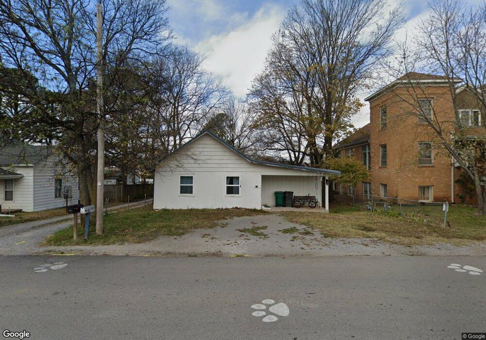
294 Main St West Fork, AR 72774
Estimated Value: $139,934 - $253,000
--
Bed
1
Bath
1,050
Sq Ft
$182/Sq Ft
Est. Value
About This Home
This home is located at 294 Main St, West Fork, AR 72774 and is currently estimated at $190,984, approximately $181 per square foot. 294 Main St is a home located in Washington County with nearby schools including West Fork Elementary School, West Fork Middle School, and West Fork High School.
Ownership History
Date
Name
Owned For
Owner Type
Purchase Details
Closed on
Nov 28, 2012
Sold by
Turner Jerry
Bought by
Basler Pasty
Current Estimated Value
Purchase Details
Closed on
Apr 30, 1996
Bought by
Cherokee Newspaper Group
Purchase Details
Closed on
May 1, 1993
Bought by
Cherokee Communications Corp.
Purchase Details
Closed on
Aug 1, 1985
Bought by
Cherokee Communications Corp.
Purchase Details
Closed on
Oct 7, 1982
Bought by
Roach Norbert and Roach Mary
Purchase Details
Closed on
Aug 16, 1977
Bought by
Carter William and Carter Elizabeth
Purchase Details
Closed on
Mar 10, 1975
Bought by
Davis Claude and Davis Allie B
Purchase Details
Closed on
Aug 29, 1958
Bought by
Sperduto Theodore C and Sperduto Muriel R
Purchase Details
Closed on
Sep 19, 1953
Bought by
Ray Charles E
Purchase Details
Closed on
Mar 9, 1936
Bought by
Ray Sylvia A
Purchase Details
Closed on
Mar 4, 1935
Bought by
Dixon George W
Purchase Details
Closed on
May 25, 1933
Bought by
Smith Luke and Smith Osie
Purchase Details
Closed on
Mar 24, 1933
Bought by
Denton-Coleman Loans & Title Co
Purchase Details
Closed on
Jun 14, 1928
Bought by
Ray Sylvia A
Create a Home Valuation Report for This Property
The Home Valuation Report is an in-depth analysis detailing your home's value as well as a comparison with similar homes in the area
Home Values in the Area
Average Home Value in this Area
Purchase History
| Date | Buyer | Sale Price | Title Company |
|---|---|---|---|
| Basler Pasty | -- | None Available | |
| Cherokee Newspaper Group | -- | -- | |
| Cherokee Communications Corp. | -- | -- | |
| Cherokee Communications Corp. | $25,000 | -- | |
| Roach Norbert | $18,000 | -- | |
| Carter William | $9,000 | -- | |
| Davis Claude | $8,000 | -- | |
| Sperduto Theodore C | -- | -- | |
| Ray Charles E | -- | -- | |
| Ray Sylvia A | $900 | -- | |
| Dixon George W | $1,400 | -- | |
| Smith Luke | $1,800 | -- | |
| Denton-Coleman Loans & Title Co | -- | -- | |
| Ray Sylvia A | -- | -- |
Source: Public Records
Tax History Compared to Growth
Tax History
| Year | Tax Paid | Tax Assessment Tax Assessment Total Assessment is a certain percentage of the fair market value that is determined by local assessors to be the total taxable value of land and additions on the property. | Land | Improvement |
|---|---|---|---|---|
| 2025 | -- | $17,800 | $5,000 | $12,800 |
| 2024 | -- | $17,800 | $5,000 | $12,800 |
| 2023 | $0 | $17,800 | $5,000 | $12,800 |
| 2022 | $0 | $12,280 | $3,750 | $8,530 |
| 2021 | $0 | $12,280 | $3,750 | $8,530 |
| 2020 | $0 | $12,280 | $3,750 | $8,530 |
| 2019 | $0 | $8,540 | $2,400 | $6,140 |
| 2018 | $0 | $8,540 | $2,400 | $6,140 |
| 2017 | $0 | $8,540 | $2,400 | $6,140 |
| 2016 | -- | $8,540 | $2,400 | $6,140 |
| 2015 | -- | $8,540 | $2,400 | $6,140 |
| 2014 | -- | $5,577 | $2,200 | $3,377 |
Source: Public Records
Map
Nearby Homes
- 302 Mcknight Ave
- 185 Wheeler St
- 0000 Highway 170
- 340 W Smith St
- 321 Cedar Springs Place
- Springs 1445 Plan at Rolling Plains
- Eureka 1536 Plan at Rolling Plains
- Oak 1463 Plan at Rolling Plains
- Magnolia 1556 Plan at Rolling Plains
- Ashton 1496 Plan at Rolling Plains
- Ouachita 1669 Plan at Rolling Plains
- Osage 1567 Plan at Rolling Plains
- Maple 1659 Plan at Rolling Plains
- 393 W Smith St
- 365 W Smith St
- 327 W Smith St
- 385 W Smith St
- 359 W Smith St
- 339 W Smith St
- 222 Rivendale Dr
- 294 W Main St
- 288 Main St
- 302 Main St
- 259 Mcknight Ave
- 285 Mcknight Ave
- 254 Mcknight Ave
- 253 Mcknight Ave
- 314 Main St
- 250 Mcknight Ave
- 247 Mcknight Ave
- 295 McDonald St
- Box317 Low Gap Rd
- 11084 Pierce Rd
- 20064 Cove Creek Rd
- 0 W 39 Ac - 156 Hwy Unit 613013
- 12.18 Ac W 156 Hwy
- 11195 W 156 Hwy
- 12417 Green Plastic Rd
- 301 McDonald St
- 246 Mcknight Ave