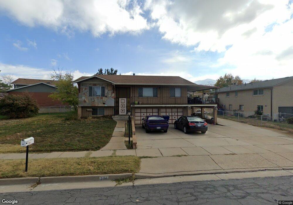
294 Maple Dr North Salt Lake, UT 84054
Estimated Value: $470,000 - $522,000
3
Beds
2
Baths
1,257
Sq Ft
$395/Sq Ft
Est. Value
About This Home
This home is located at 294 Maple Dr, North Salt Lake, UT 84054 and is currently estimated at $496,770, approximately $395 per square foot. 294 Maple Dr is a home located in Davis County with nearby schools including Adelaide School, South Davis Junior High School, and Woods Cross High School.
Ownership History
Date
Name
Owned For
Owner Type
Purchase Details
Closed on
Sep 19, 2017
Sold by
Wright Ronald Christopher and Wright Valerie
Bought by
Wright Ronald Christopher and Wright Valerie
Current Estimated Value
Purchase Details
Closed on
Jul 2, 2009
Sold by
Wright Ronald and Wright Valerie
Bought by
Wright Ronald Christopher and Wright Valerie
Purchase Details
Closed on
Oct 10, 2006
Sold by
Wood Jack B
Bought by
Wright Ron and Wright Valerie
Home Financials for this Owner
Home Financials are based on the most recent Mortgage that was taken out on this home.
Original Mortgage
$35,000
Interest Rate
6.39%
Mortgage Type
Stand Alone Second
Purchase Details
Closed on
Mar 11, 2002
Sold by
Wood Freda B
Bought by
Wood Freda B and The Wood Family Trust
Create a Home Valuation Report for This Property
The Home Valuation Report is an in-depth analysis detailing your home's value as well as a comparison with similar homes in the area
Home Values in the Area
Average Home Value in this Area
Purchase History
| Date | Buyer | Sale Price | Title Company |
|---|---|---|---|
| Wright Ronald Christopher | -- | -- | |
| Wright Ronald Christopher | -- | Cottonwood Title Ins Agency | |
| Wright Ron | -- | Backman Title Services | |
| Wood Freda B | -- | Aspen Title Insurance Agency |
Source: Public Records
Mortgage History
| Date | Status | Borrower | Loan Amount |
|---|---|---|---|
| Previous Owner | Wright Ron | $35,000 | |
| Previous Owner | Wright Ron | $140,000 |
Source: Public Records
Tax History Compared to Growth
Tax History
| Year | Tax Paid | Tax Assessment Tax Assessment Total Assessment is a certain percentage of the fair market value that is determined by local assessors to be the total taxable value of land and additions on the property. | Land | Improvement |
|---|---|---|---|---|
| 2025 | $2,469 | $244,200 | $110,834 | $133,366 |
| 2024 | $2,346 | $235,950 | $117,996 | $117,954 |
| 2023 | $2,211 | $402,000 | $156,166 | $245,834 |
| 2022 | $2,303 | $229,900 | $137,367 | $92,533 |
| 2021 | $2,185 | $331,000 | $99,538 | $231,462 |
| 2020 | $1,962 | $294,000 | $85,550 | $208,450 |
| 2019 | $1,957 | $286,000 | $88,471 | $197,529 |
| 2018 | $1,778 | $257,000 | $87,881 | $169,119 |
| 2016 | $1,515 | $116,435 | $34,512 | $81,923 |
| 2015 | $1,286 | $94,989 | $34,512 | $60,477 |
| 2014 | $1,320 | $99,374 | $34,512 | $64,862 |
| 2013 | -- | $98,845 | $27,392 | $71,453 |
Source: Public Records
Map
Nearby Homes
- 284 N 100 E
- 70 E North Town Ln
- 189 E 210 N Unit 8
- 410 N 175 E
- 252 E Kirsten Ln
- 1443 E Cove Crest Ct Unit 1406
- 1423 E Wood Oaks Loop S Unit 1313
- 1428 E Cove Crest Ct S Unit 1404
- 3573 S Highway 89
- 55 W Center St Unit 206
- 55 W Center St Unit 331
- 72 S 130 E
- 562 Lancelot Dr Unit 60
- 167 Guenevere St Unit 128
- 2420 S Orchard Dr
- 621 Excalibur St Unit 143
- 246 N Glenwood Way
- 626 Sagramore St
- 246 Galahad St
- 259 Lionel St Unit 373