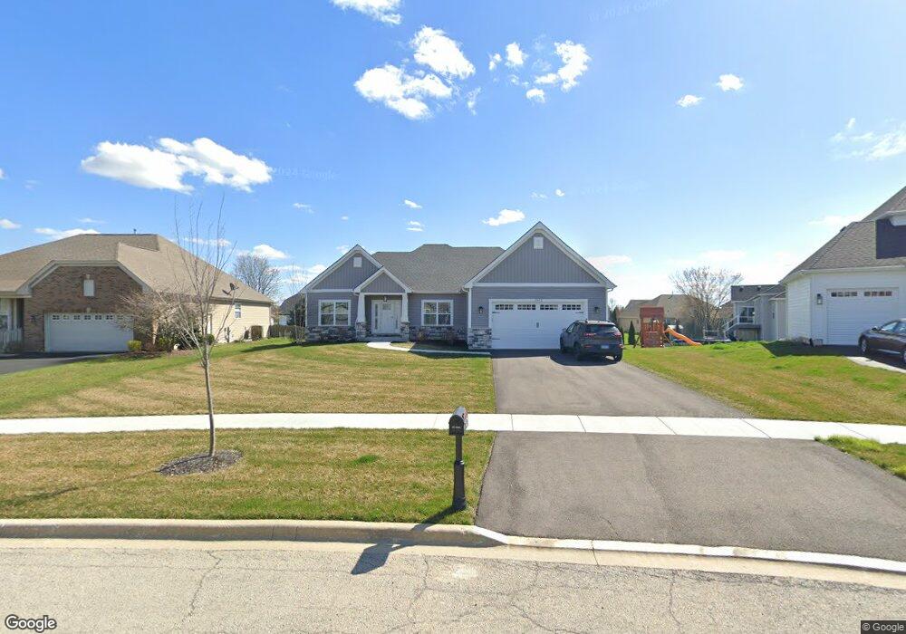
2942 Hampton Ave North Aurora, IL 60542
Nelson Lake NeighborhoodEstimated Value: $575,000 - $611,000
Studio
--
Bath
--
Sq Ft
13,504
Sq Ft Lot
About This Home
This home is located at 2942 Hampton Ave, North Aurora, IL 60542 and is currently estimated at $591,868. 2942 Hampton Ave is a home located in Kane County with nearby schools including Kaneland Blackberry Creek Elementary School, Harter Middle School, and Kaneland High School.
Ownership History
Date
Name
Owned For
Owner Type
Purchase Details
Closed on
Mar 3, 2023
Sold by
Mccue Builders Inc
Bought by
Gambino Andrew and Gambino Barbara Ann
Current Estimated Value
Purchase Details
Closed on
Oct 22, 2020
Sold by
Phoenix Group Ii Llc
Bought by
Mccue Builders Inc
Purchase Details
Closed on
Nov 11, 2011
Sold by
Phoenix Group I Llc
Bought by
Phoenix Group Ii Llc
Purchase Details
Closed on
Dec 28, 2009
Sold by
Remington Landing Llc
Bought by
Phoenix Group I Llc
Create a Home Valuation Report for This Property
The Home Valuation Report is an in-depth analysis detailing your home's value as well as a comparison with similar homes in the area
Home Values in the Area
Average Home Value in this Area
Purchase History
| Date | Buyer | Sale Price | Title Company |
|---|---|---|---|
| Gambino Andrew | $503,000 | Wheatland Title | |
| Mccue Builders Inc | $564,000 | Chicago Title Insurance Co | |
| Phoenix Group Ii Llc | $792,500 | Chicago Title Insurance Co | |
| Phoenix Group I Llc | $500,000 | Chicago Title Insurance Co |
Source: Public Records
Tax History
| Year | Tax Paid | Tax Assessment Tax Assessment Total Assessment is a certain percentage of the fair market value that is determined by local assessors to be the total taxable value of land and additions on the property. | Land | Improvement |
|---|---|---|---|---|
| 2024 | $9,898 | $126,085 | $12,735 | $113,350 |
| 2023 | $9,235 | $108,623 | $11,494 | $97,129 |
| 2022 | $1,041 | $10,549 | $10,549 | $0 |
| 2021 | $299 | $2,975 | $2,975 | $0 |
| 2020 | $295 | $2,905 | $2,905 | $0 |
| 2019 | $299 | $2,862 | $2,862 | $0 |
| 2018 | $307 | $2,862 | $2,862 | $0 |
| 2017 | $310 | $2,829 | $2,829 | $0 |
| 2016 | $308 | $2,754 | $2,754 | $0 |
| 2015 | -- | $2,647 | $2,647 | $0 |
| 2014 | -- | $2,647 | $2,647 | $0 |
| 2013 | -- | $2,647 | $2,647 | $0 |
Source: Public Records
Map
Nearby Homes
- 621 Western Dr Unit 2
- 2924 Bauer Rd
- 2921 Mc Duffee Cir Unit 1A
- 3S791 Terrace Dr
- 2593 Moutray Ln
- 2772 Berman Rd Unit 1A
- 601 Meade Blvd
- 2518 Imgrund Rd Unit 3
- 1009 Bennett Ct
- 443 Glover Dr
- 4s072 Deerpath Rd
- 2S976 Deerpath Rd
- 3S177 Deerpath Rd
- 924 Fair Meadow St
- 2S720 Nelson Lake Rd
- 867 Fair Meadow Ct
- 925 Fair Meadow St
- 965 Carmen Rd
- 1791 Breton Ave
- 1799 Breton Ave
- 2934 Hampton Ave
- 2926 Hampton Ave
- 2941 Carlisle Ln
- 735 Remington Ln
- 2933 Carlisle Ln
- 2949 Carlisle Ln
- 2918 Hampton Ave
- 2925 Carlisle Ln
- 743 Remington Ln
- 12 Remington Ln
- 2957 Carlisle Ln
- 2935 Hampton Ave
- 2943 Hampton Ave
- 2917 Carlisle Ln
- 2927 Hampton Ave
- 2910 Hampton Ave
- 2965 Carlisle Ln
- 2919 Hampton Ave
- 2909 Carlisle Ln
- 742 Remington Ln
Your Personal Tour Guide
Ask me questions while you tour the home.