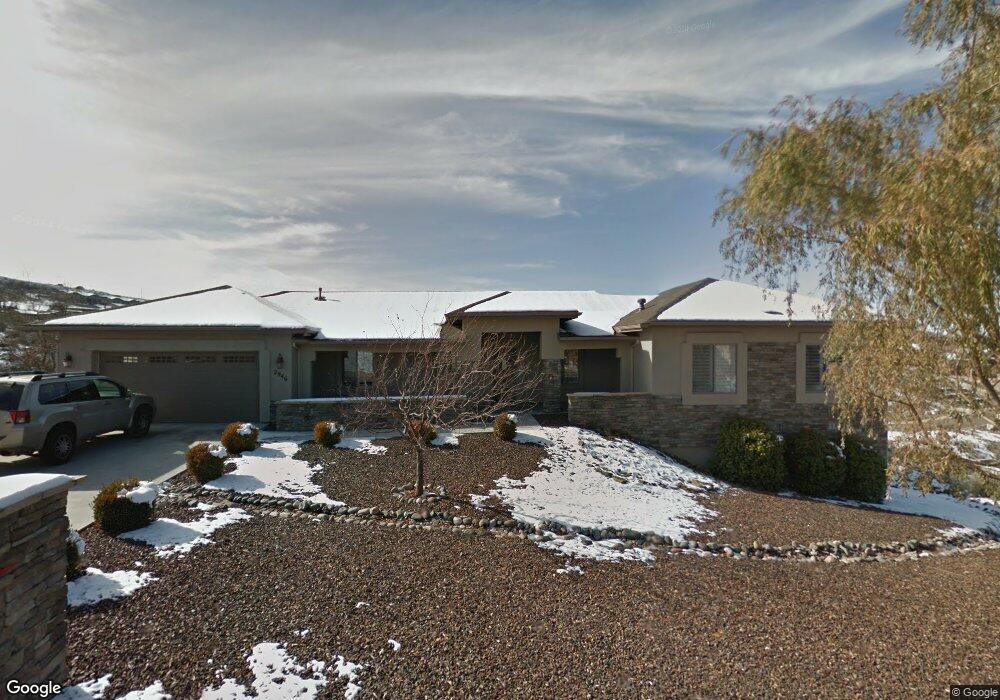
2946 Brooks Range Unit 1 Prescott, AZ 86301
Prescott Lakes NeighborhoodEstimated Value: $788,163 - $1,077,000
4
Beds
3
Baths
3,568
Sq Ft
$267/Sq Ft
Est. Value
About This Home
This home is located at 2946 Brooks Range Unit 1, Prescott, AZ 86301 and is currently estimated at $951,291, approximately $266 per square foot. 2946 Brooks Range Unit 1 is a home located in Yavapai County with nearby schools including Granite Mountain Middle School, Abia Judd Elementary School, and Prescott Mile High Middle School.
Ownership History
Date
Name
Owned For
Owner Type
Purchase Details
Closed on
Aug 22, 2011
Sold by
Thompson Carolyn
Bought by
Sullivan Michael J and Sullivan Kathleen
Current Estimated Value
Purchase Details
Closed on
Nov 11, 2003
Sold by
Townsend Construction Inc
Bought by
Thompson Carolyn
Purchase Details
Closed on
Dec 26, 2002
Sold by
National Bank Of Arizona Na
Bought by
Townsend Construction Inc
Home Financials for this Owner
Home Financials are based on the most recent Mortgage that was taken out on this home.
Original Mortgage
$40,500
Interest Rate
6.15%
Purchase Details
Closed on
Apr 12, 2002
Sold by
Pl Custom Investors Llc
Bought by
National Bank Of Arizona Na
Create a Home Valuation Report for This Property
The Home Valuation Report is an in-depth analysis detailing your home's value as well as a comparison with similar homes in the area
Home Values in the Area
Average Home Value in this Area
Purchase History
| Date | Buyer | Sale Price | Title Company |
|---|---|---|---|
| Sullivan Michael J | $325,000 | Yavapai Title Agency Inc | |
| Thompson Carolyn | $285,000 | Chicago Title Ins Co | |
| Townsend Construction Inc | $40,500 | Chicago Title Insurance Co | |
| National Bank Of Arizona Na | $4,586,554 | First American Title Ins Co |
Source: Public Records
Mortgage History
| Date | Status | Borrower | Loan Amount |
|---|---|---|---|
| Previous Owner | Townsend Construction Inc | $40,500 | |
| Closed | Townsend Construction Inc | $119,500 |
Source: Public Records
Tax History
| Year | Tax Paid | Tax Assessment Tax Assessment Total Assessment is a certain percentage of the fair market value that is determined by local assessors to be the total taxable value of land and additions on the property. | Land | Improvement |
|---|---|---|---|---|
| 2026 | $1,993 | $60,973 | -- | -- |
| 2024 | $1,950 | $65,657 | -- | -- |
| 2023 | $1,950 | $51,484 | $6,308 | $45,176 |
| 2022 | $1,924 | $43,360 | $5,424 | $37,936 |
| 2021 | $2,064 | $42,908 | $4,806 | $38,102 |
| 2020 | $2,073 | $0 | $0 | $0 |
| 2019 | $2,059 | $0 | $0 | $0 |
| 2018 | $1,967 | $0 | $0 | $0 |
| 2017 | $1,896 | $0 | $0 | $0 |
| 2016 | $1,888 | $0 | $0 | $0 |
| 2015 | $1,831 | $0 | $0 | $0 |
| 2014 | $1,825 | $0 | $0 | $0 |
Source: Public Records
Map
Nearby Homes
- 806 Hoosier Pass
- 696 Mines Pass
- 3100 Montana Dr
- 869 Mines Pass
- 715 N Lakeview Dr
- 865 Crystal View Dr
- 3089 Peaks View Ln Unit A6
- 3059 Smokey Rd Unit 21E
- 3096 Adobe Springs Dr
- 3160 Cascades Dr Unit 16H
- 2680 Trail Walk
- 3144 Trail Walk
- 968 Louie St
- 3168 Shoshone Dr Unit 10A
- 3069 Tetons Ct Unit 9d
- 3170 Trail Walk
- 3169 Dome Rock Place Unit A12
- 3169 Dome Rock Place Unit 12A
- 3169 Dome Rock Place Unit 12g
- 2636 College Heights Rd
- 2934 Brooks Range
- 2958 Brooks Range Unit 25
- 2958 Brooks Range
- 2949 Noble Star Dr
- 2957 Noble Star Dr
- 2957 Noble Star Dr Unit 15
- 2945 Noble Star Dr
- 2945 Noble Star Dr Unit 13
- 803 Hoosier Pass
- 2933 Brooks Range
- 2922 Brooks Range
- 2970 Brooks Range
- 0 Noble Star Dr
- 31 Noble Star Dr
- 16 Noble Star Dr
- 20 Noble Star Dr
- 32 Noble Star Dr
- 29 Noble Star Dr
- 2933 Noble Star Dr Unit 12
- 2933 Noble Star Dr
Your Personal Tour Guide
Ask me questions while you tour the home.