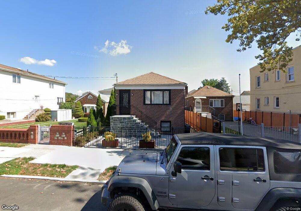
295 Mallory Ave Staten Island, NY 10305
South Beach NeighborhoodEstimated Value: $414,035 - $616,000
--
Bed
4
Baths
600
Sq Ft
$846/Sq Ft
Est. Value
About This Home
This home is located at 295 Mallory Ave, Staten Island, NY 10305 and is currently estimated at $507,759, approximately $846 per square foot. 295 Mallory Ave is a home located in Richmond County with nearby schools including P.S. 46 Albert V Maniscalco, I.S. 49 Berta A Dreyfus, and Curtis High School.
Ownership History
Date
Name
Owned For
Owner Type
Purchase Details
Closed on
Oct 1, 2014
Sold by
Hladek Rosalyn and Esposito Madeline
Bought by
Hajri Melani Fatrije and Hajri Melani
Current Estimated Value
Home Financials for this Owner
Home Financials are based on the most recent Mortgage that was taken out on this home.
Original Mortgage
$208,000
Outstanding Balance
$159,403
Interest Rate
4.09%
Mortgage Type
New Conventional
Estimated Equity
$348,356
Purchase Details
Closed on
Oct 15, 2003
Sold by
Gemarro Angelina
Bought by
Hladek Rosalyn and Esposito Madeline
Create a Home Valuation Report for This Property
The Home Valuation Report is an in-depth analysis detailing your home's value as well as a comparison with similar homes in the area
Home Values in the Area
Average Home Value in this Area
Purchase History
| Date | Buyer | Sale Price | Title Company |
|---|---|---|---|
| Hajri Melani Fatrije | $260,000 | None Available | |
| Hladek Rosalyn | -- | Washington Title Insurance C |
Source: Public Records
Mortgage History
| Date | Status | Borrower | Loan Amount |
|---|---|---|---|
| Open | Hajri Melani Fatrije | $208,000 |
Source: Public Records
Tax History Compared to Growth
Tax History
| Year | Tax Paid | Tax Assessment Tax Assessment Total Assessment is a certain percentage of the fair market value that is determined by local assessors to be the total taxable value of land and additions on the property. | Land | Improvement |
|---|---|---|---|---|
| 2025 | $3,124 | $25,860 | $3,392 | $22,468 |
| 2024 | $3,124 | $27,600 | $3,178 | $24,422 |
| 2023 | $3,135 | $15,434 | $3,161 | $12,273 |
| 2022 | $2,907 | $22,380 | $5,640 | $16,740 |
| 2021 | $2,891 | $23,580 | $5,640 | $17,940 |
| 2020 | $2,743 | $20,340 | $5,640 | $14,700 |
| 2019 | $2,711 | $20,940 | $5,640 | $15,300 |
| 2018 | $2,622 | $12,862 | $3,331 | $9,531 |
| 2017 | $2,473 | $12,134 | $4,304 | $7,830 |
| 2016 | $2,289 | $11,448 | $4,428 | $7,020 |
| 2015 | $428 | $10,800 | $4,680 | $6,120 |
| 2014 | $428 | $10,800 | $4,680 | $6,120 |
Source: Public Records
Map
Nearby Homes
- 182 Olympia Blvd
- 11 Lava St
- 40 Mclaughlin St
- 62 Mclaughlin St
- 236 Mallory Ave
- 49 Mclaughlin St
- 84 Winfield St
- 104 Winfield St
- 53 Andrews St
- 200 Mallory Ave
- 220 Norway Ave
- 166 Jerome Ave
- 504 Mcclean Ave
- 116 Bionia Ave
- 150 Linwood Ave
- 12 Reid Ave
- 71 Cameron Ave
- 55 Lansing St
- 46 Olympia Blvd
- 44 Olympia Blvd
- 299 Mallory Ave
- 301 Mallory Ave
- 293 Mallory Ave
- 290 Lamport Blvd
- 287 Mallory Ave
- 286 Lamport Blvd
- 303 Mallory Ave
- 223 Olympia Blvd
- 284 Lamport Blvd Unit 286
- 284-286 Lamport Blvd
- 282 Lamport Blvd
- 219 Olympia Blvd
- 219 Olympia Blvd Unit 1
- 280 Lamport Blvd
- 300 Mallory Ave
- 290 Mallory Ave
- 304 Mallory Ave
- 211 Olympia Blvd
- 308 Mallory Ave
- 288 Mallory Ave