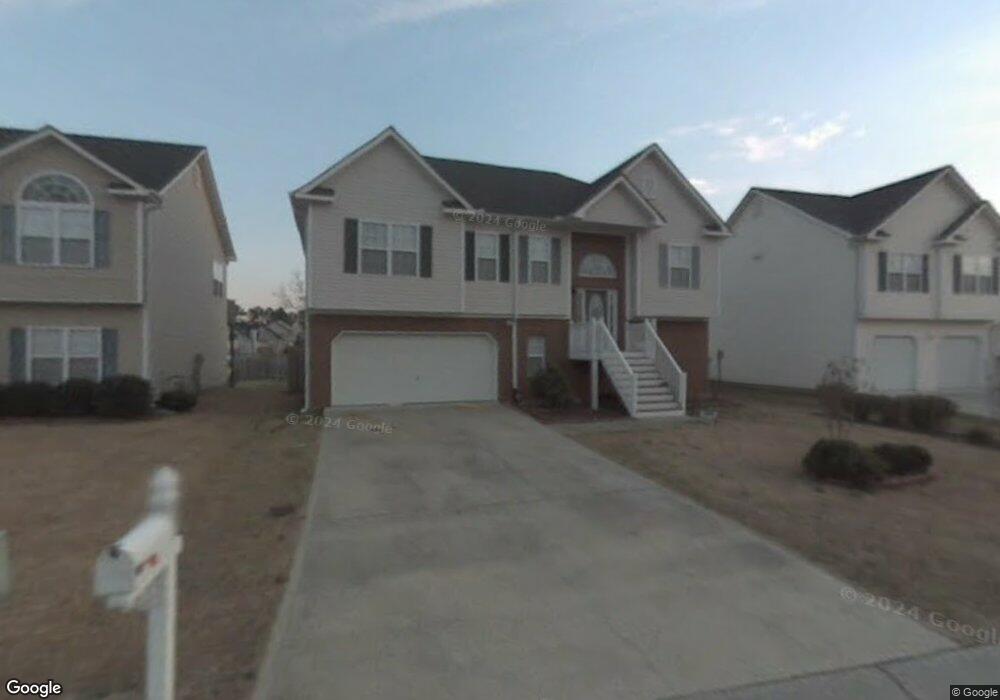
295 Moreland Cir Hiram, GA 30141
East Paulding County NeighborhoodEstimated Value: $316,000 - $341,000
3
Beds
3
Baths
1,497
Sq Ft
$216/Sq Ft
Est. Value
About This Home
This home is located at 295 Moreland Cir, Hiram, GA 30141 and is currently estimated at $323,310, approximately $215 per square foot. 295 Moreland Cir is a home located in Paulding County with nearby schools including Mcgarity Elementary School, P. B. Ritch Middle School, and East Paulding High School.
Ownership History
Date
Name
Owned For
Owner Type
Purchase Details
Closed on
Jan 29, 2009
Sold by
Hud & Housing Of Urban Dev
Bought by
Chancellor Rocky W and Chancellor Heather C
Current Estimated Value
Home Financials for this Owner
Home Financials are based on the most recent Mortgage that was taken out on this home.
Original Mortgage
$119,032
Outstanding Balance
$75,162
Interest Rate
5.08%
Mortgage Type
Stand Alone Second
Estimated Equity
$248,148
Purchase Details
Closed on
Jul 1, 2008
Sold by
Wells Fargo Bk Na
Bought by
Hud-Housing Of Urban Dev
Create a Home Valuation Report for This Property
The Home Valuation Report is an in-depth analysis detailing your home's value as well as a comparison with similar homes in the area
Home Values in the Area
Average Home Value in this Area
Purchase History
| Date | Buyer | Sale Price | Title Company |
|---|---|---|---|
| Chancellor Rocky W | $116,205 | -- | |
| Hud-Housing Of Urban Dev | -- | -- | |
| Wells Fargo Bk Na | $154,369 | -- |
Source: Public Records
Mortgage History
| Date | Status | Borrower | Loan Amount |
|---|---|---|---|
| Open | Chancellor Rocky W | $119,032 |
Source: Public Records
Tax History Compared to Growth
Tax History
| Year | Tax Paid | Tax Assessment Tax Assessment Total Assessment is a certain percentage of the fair market value that is determined by local assessors to be the total taxable value of land and additions on the property. | Land | Improvement |
|---|---|---|---|---|
| 2024 | $3,079 | $127,004 | $12,000 | $115,004 |
| 2023 | $3,199 | $125,232 | $12,000 | $113,232 |
| 2022 | $2,695 | $105,268 | $12,000 | $93,268 |
| 2021 | $2,128 | $75,088 | $10,000 | $65,088 |
| 2020 | $2,096 | $72,436 | $10,000 | $62,436 |
| 2019 | $2,036 | $69,444 | $10,000 | $59,444 |
| 2018 | $1,777 | $60,840 | $10,000 | $50,840 |
| 2017 | $1,558 | $52,868 | $10,000 | $42,868 |
| 2016 | $1,285 | $44,356 | $10,000 | $34,356 |
| 2015 | $1,354 | $45,840 | $10,000 | $35,840 |
| 2014 | $1,275 | $42,240 | $10,000 | $32,240 |
| 2013 | -- | $28,440 | $10,000 | $18,440 |
Source: Public Records
Map
Nearby Homes
- 45 Waterloo Ct
- 334 Covington Dr
- 119 English Barn Way
- 0 MacLand Rd Unit 10558702
- 1083 Handy Rd
- 17 Rackley Way
- 7 Hickory Branch
- 132 English Barn Way
- 142 English Barn Way
- 152 English Barn Way
- 4622 MacLand Rd
- 162 English Barn Way
- 4624 MacLand Rd
- 20 Weathervane Way
- 34 English Barn Way
- 258 Cristy Dr
- 44 English Barn Way
- 225 Harvest Trail
- 56 English Barn Way
- 184 Darbys Crossing Ct
- 281 Moreland Cir
- 307 Moreland Cir
- 255 Moreland Cir
- 225 Moreland Cir
- 321 Moreland Cir
- 206 Richmond Dr
- 209 Moreland Cir
- 194 Richmond Dr
- 292 Moreland Cir
- 302 Moreland Cir
- 280 Moreland Cir
- 314 Moreland Cir
- 197 Moreland Cir Unit GA1341
- 197 Moreland Cir
- 197 Moreland Cir Unit GA13416
- 197 Moreland Cir
- 186 Richmond Dr
- 262 Moreland Cir
- 232 Moreland Cir
- 185 Moreland Cir