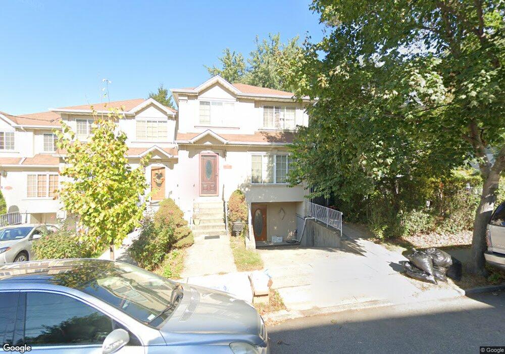
295 Myrtle Ave Staten Island, NY 10310
West Brighton NeighborhoodEstimated Value: $644,892 - $739,000
3
Beds
3
Baths
1,580
Sq Ft
$428/Sq Ft
Est. Value
About This Home
This home is located at 295 Myrtle Ave, Staten Island, NY 10310 and is currently estimated at $676,723, approximately $428 per square foot. 295 Myrtle Ave is a home located in Richmond County with nearby schools including P.S. 19 The Curtis School, Intermediate School 27, and Susan E Wagner High School.
Ownership History
Date
Name
Owned For
Owner Type
Purchase Details
Closed on
May 3, 2004
Sold by
Cantin Bruce S and Cantin Diana
Bought by
Jervis Aluko O and Jervis Nalini
Current Estimated Value
Home Financials for this Owner
Home Financials are based on the most recent Mortgage that was taken out on this home.
Original Mortgage
$287,200
Interest Rate
6.03%
Mortgage Type
Purchase Money Mortgage
Purchase Details
Closed on
Aug 11, 2000
Sold by
Mandori Development Corp
Bought by
Cantin Bruce S and Cantin Diana
Home Financials for this Owner
Home Financials are based on the most recent Mortgage that was taken out on this home.
Original Mortgage
$157,500
Interest Rate
8.07%
Create a Home Valuation Report for This Property
The Home Valuation Report is an in-depth analysis detailing your home's value as well as a comparison with similar homes in the area
Home Values in the Area
Average Home Value in this Area
Purchase History
| Date | Buyer | Sale Price | Title Company |
|---|---|---|---|
| Jervis Aluko O | $359,000 | Commonwealth Land Title | |
| Cantin Bruce S | $213,000 | Lawyers Title Insurance Corp |
Source: Public Records
Mortgage History
| Date | Status | Borrower | Loan Amount |
|---|---|---|---|
| Previous Owner | Jervis Aluko O | $287,200 | |
| Previous Owner | Cantin Bruce S | $157,500 |
Source: Public Records
Tax History Compared to Growth
Tax History
| Year | Tax Paid | Tax Assessment Tax Assessment Total Assessment is a certain percentage of the fair market value that is determined by local assessors to be the total taxable value of land and additions on the property. | Land | Improvement |
|---|---|---|---|---|
| 2025 | $5,684 | $34,320 | $5,139 | $29,181 |
| 2024 | $5,684 | $30,120 | $5,524 | $24,596 |
| 2023 | $5,422 | $26,698 | $4,854 | $21,844 |
| 2022 | $5,261 | $26,880 | $5,880 | $21,000 |
| 2021 | $5,404 | $25,680 | $5,880 | $19,800 |
| 2020 | $5,291 | $25,440 | $5,880 | $19,560 |
| 2019 | $4,933 | $26,220 | $5,880 | $20,340 |
| 2018 | $4,535 | $22,248 | $5,877 | $16,371 |
| 2017 | $4,477 | $21,960 | $5,518 | $16,442 |
| 2016 | $4,390 | $21,960 | $5,575 | $16,385 |
| 2015 | $3,771 | $20,831 | $4,866 | $15,965 |
| 2014 | $3,771 | $19,652 | $4,868 | $14,784 |
Source: Public Records
Map
Nearby Homes
- 704 Delafield Ave
- 448 Clove Rd
- 433 Clove Rd
- 771 Delafield Ave
- 657 Delafield Ave
- 123 Roe St
- 10 Ludwig St
- 6 Ludwig St
- 109 Lyceum Ct
- 62 Lyceum Ct
- 582 Cary Ave
- 837 Delafield Ave Unit A
- 722 Post Ave
- 61 Greenleaf Ave
- 12 Freeman Place
- 46 Elizabeth St
- 886 Delafield Ave
- 1198 Castleton Ave
- 176 Dubois Ave
- 361 Broadway