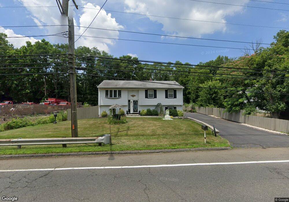
295 State Route 79 N Morganville, NJ 07751
Estimated Value: $352,240 - $366,000
3
Beds
2
Baths
2,304
Sq Ft
$156/Sq Ft
Est. Value
About This Home
This home is located at 295 State Route 79 N, Morganville, NJ 07751 and is currently estimated at $358,560, approximately $155 per square foot. 295 State Route 79 N is a home located in Monmouth County with nearby schools including Frank Defino Central Elementary School, Marlboro Memorial Middle School, and Marlboro High School.
Ownership History
Date
Name
Owned For
Owner Type
Purchase Details
Closed on
May 5, 2025
Sold by
Hyle Dolores A and Della Petro Sabina
Bought by
Samm79 Llc
Current Estimated Value
Home Financials for this Owner
Home Financials are based on the most recent Mortgage that was taken out on this home.
Original Mortgage
$100,000
Outstanding Balance
$94,337
Interest Rate
6.81%
Mortgage Type
New Conventional
Estimated Equity
$264,223
Purchase Details
Closed on
Jul 23, 1968
Bought by
Della Pietro Anthony and Della Pietro Sabina
Create a Home Valuation Report for This Property
The Home Valuation Report is an in-depth analysis detailing your home's value as well as a comparison with similar homes in the area
Home Values in the Area
Average Home Value in this Area
Purchase History
| Date | Buyer | Sale Price | Title Company |
|---|---|---|---|
| Samm79 Llc | $353,500 | Fidelity National Title | |
| Samm79 Llc | $353,500 | Fidelity National Title | |
| Della Pietro Anthony | $20,000 | -- |
Source: Public Records
Mortgage History
| Date | Status | Borrower | Loan Amount |
|---|---|---|---|
| Open | Samm79 Llc | $100,000 | |
| Closed | Samm79 Llc | $100,000 |
Source: Public Records
Tax History Compared to Growth
Tax History
| Year | Tax Paid | Tax Assessment Tax Assessment Total Assessment is a certain percentage of the fair market value that is determined by local assessors to be the total taxable value of land and additions on the property. | Land | Improvement |
|---|---|---|---|---|
| 2025 | $7,506 | $297,500 | $138,800 | $158,700 |
| 2024 | $7,182 | $297,500 | $138,800 | $158,700 |
| 2023 | $7,182 | $297,500 | $138,800 | $158,700 |
| 2022 | $6,979 | $297,500 | $138,800 | $158,700 |
| 2021 | $6,884 | $297,500 | $138,800 | $158,700 |
| 2020 | $6,878 | $297,500 | $138,800 | $158,700 |
| 2019 | $6,884 | $297,500 | $138,800 | $158,700 |
| 2018 | $6,765 | $297,500 | $138,800 | $158,700 |
| 2017 | $6,634 | $297,500 | $138,800 | $158,700 |
| 2016 | $6,607 | $297,500 | $138,800 | $158,700 |
| 2015 | $6,420 | $293,400 | $138,800 | $154,600 |
| 2014 | $6,105 | $276,000 | $138,800 | $137,200 |
Source: Public Records
Map
Nearby Homes
- 309 Highway 79
- 33 Harbor Rd
- 124 Village Rd
- 15 Village Rd
- 119 Village Rd
- 30 Pleasant Valley Rd
- 32 Village Rd
- 16 Pleasant Valley Rd
- 135 Village Rd
- 14 Village Rd
- 93 Village Rd
- 43 Shawnee Way
- 75 Village Rd
- 61 Village Rd
- 138 Briarcliff Dr
- 14 Saratoga Ct
- 70 Crescent Ct
- 193 Highway 79
- 320 Sinclair Ct
- 120 Crine Rd
- 297 State Route 79 N
- 289 State Route 79 N
- 305 State Route 79
- 287 State Route 79 N
- 294 State Route 79 N
- 301 Highway 79
- 301 State Route 79
- 7 Harbor Rd
- 285 State Route 79 N
- 11 Harbor Rd
- 325 Flower Ln
- 311 State Route 79
- 283 Highway 79
- 162 Fella Dr
- 206 Conway Ct
- 317 Flower Ln
- 281 Highway 79
- 281 Highway 79 Unit 215,203
- 281 Highway 79 Unit 106-107
- 17 Harbor Rd