Estimated Value: $50,000 - $64,467
4
Beds
2
Baths
--
Sq Ft
9,714
Sq Ft Lot
About This Home
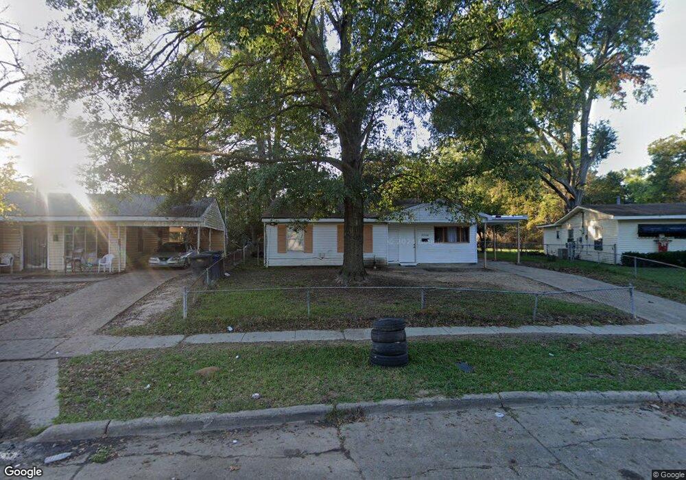
This home is located at 2956 Despot Rd, Shreveport, LA 71108 and is currently estimated at $58,867. 2956 Despot Rd is a home located in Caddo Parish with nearby schools including Fairfield Magnet School, South Highlands Elementary, and Judson Fundamental Elementary School.
Ownership History
Date
Name
Owned For
Owner Type
Purchase Details
Closed on
May 5, 2017
Sold by
Keithville Land Company Llc
Bought by
Po Folks Tax Properties Llc
Current Estimated Value
Purchase Details
Closed on
Jun 19, 2015
Sold by
Chandles Kory E and Chandles Edward Dale
Bought by
Poehen Llc
Purchase Details
Closed on
Jun 20, 2014
Sold by
Keithville Land Co Llc
Bought by
Nebraska Alliance Realty Co
Purchase Details
Closed on
Jun 13, 2014
Sold by
State Of Louisiana
Bought by
Keithville Land Co Llc
Purchase Details
Closed on
Jun 21, 2013
Sold by
Poston David
Bought by
Keithville Land Co Llc
Purchase Details
Closed on
Jun 14, 2013
Sold by
Poston David
Bought by
Keithville Land Co Llc
Purchase Details
Closed on
Jun 2, 2006
Sold by
Oxbow Investments Llc
Bought by
Zydeco 1 Llc
Create a Home Valuation Report for This Property
The Home Valuation Report is an in-depth analysis detailing your home's value as well as a comparison with similar homes in the area
Home Values in the Area
Average Home Value in this Area
Purchase History
| Date | Buyer | Sale Price | Title Company |
|---|---|---|---|
| Po Folks Tax Properties Llc | -- | None Available | |
| Po Folks Tax Properties Llc | -- | None Available | |
| Poehen Llc | -- | None Available | |
| Nebraska Alliance Realty Co | $1,037 | None Available | |
| Keithville Land Co Llc | $430 | None Available | |
| Keithville Land Co Llc | $415 | None Available | |
| Keithville Land Co Llc | $1,022 | None Available | |
| Zydeco 1 Llc | $811 | None Available |
Source: Public Records
Tax History Compared to Growth
Tax History
| Year | Tax Paid | Tax Assessment Tax Assessment Total Assessment is a certain percentage of the fair market value that is determined by local assessors to be the total taxable value of land and additions on the property. | Land | Improvement |
|---|---|---|---|---|
| 2024 | $890 | $5,708 | $1,136 | $4,572 |
| 2023 | $901 | $5,654 | $1,082 | $4,572 |
| 2022 | $901 | $5,654 | $1,082 | $4,572 |
| 2021 | $887 | $5,654 | $1,082 | $4,572 |
| 2020 | $888 | $5,654 | $1,082 | $4,572 |
| 2019 | $904 | $5,590 | $1,082 | $4,508 |
| 2018 | $720 | $5,590 | $1,082 | $4,508 |
| 2017 | $918 | $5,590 | $1,082 | $4,508 |
| 2015 | $748 | $5,770 | $1,080 | $4,690 |
| 2014 | $754 | $5,770 | $1,080 | $4,690 |
| 2013 | -- | $5,770 | $1,080 | $4,690 |
Source: Public Records
Map
Nearby Homes
- 6617 Burke St
- 2943 Amherst St
- 6716 Burke St
- 2928 Amherst St
- 3030 Amherst St
- 6546 W Canal Blvd
- 0 W Canal Blvd
- 7032 Gregory St
- 6309 Quilen Blvd
- 3021 Dollarway St
- 7041 Karen St
- 2747 Parkridge St
- 7013 Janey St
- 2716 Rosemont St
- 3205 Lilac Ln
- 7209 Gregory St
- 2910 Meadow Ave
- 3506 Red Bud Ln
- 3241 Wagner St
- 3414 Woodhaven Ln
- 2960 Despot Rd
- 2952 Despot Rd
- 6647 Burke St
- 2948 Despot Rd
- 6653 Burke St
- 6643 Burke St
- 6637 Burke St
- 6633 Burke St
- 2945 Despot Rd
- 2945 Despot Rd
- 6708 Despot Rd
- 3005 Marquette Ave
- 3005 Marquette St
- 2935 Despot Rd
- 2940 Despot Rd
- 6623 Burke St
- 6705 Despot Rd
- 6712 Despot Rd
- 2928 Marquette St
- 2928 Marquette St