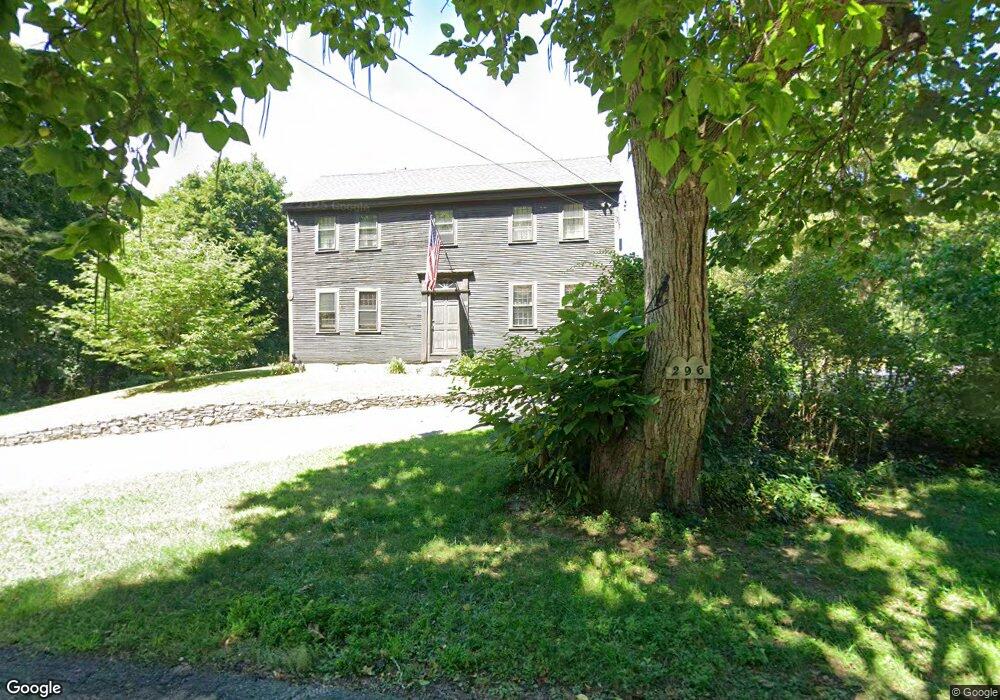
296 Bennett St Wrentham, MA 02093
Estimated Value: $425,000 - $864,000
3
Beds
2
Baths
2,053
Sq Ft
$320/Sq Ft
Est. Value
About This Home
This home is located at 296 Bennett St, Wrentham, MA 02093 and is currently estimated at $656,097, approximately $319 per square foot. 296 Bennett St is a home located in Norfolk County with nearby schools including Delaney Elementary School and Charles E Roderick.
Ownership History
Date
Name
Owned For
Owner Type
Purchase Details
Closed on
Oct 3, 1979
Bought by
Brown Roberta H
Current Estimated Value
Create a Home Valuation Report for This Property
The Home Valuation Report is an in-depth analysis detailing your home's value as well as a comparison with similar homes in the area
Purchase History
| Date | Buyer | Sale Price | Title Company |
|---|---|---|---|
| Brown Roberta H | $22,000 | -- |
Source: Public Records
Mortgage History
| Date | Status | Borrower | Loan Amount |
|---|---|---|---|
| Open | Brown Roberta H | $100,000 | |
| Closed | Brown Roberta H | $24,000 | |
| Closed | Brown Roberta H | $70,000 |
Source: Public Records
Tax History
| Year | Tax Paid | Tax Assessment Tax Assessment Total Assessment is a certain percentage of the fair market value that is determined by local assessors to be the total taxable value of land and additions on the property. | Land | Improvement |
|---|---|---|---|---|
| 2025 | $5,964 | $514,600 | $287,900 | $226,700 |
| 2024 | $6,047 | $503,900 | $287,900 | $216,000 |
| 2023 | $5,263 | $417,000 | $261,800 | $155,200 |
| 2022 | $6,061 | $443,400 | $255,000 | $188,400 |
| 2021 | $5,908 | $419,900 | $238,300 | $181,600 |
| 2020 | $5,177 | $363,300 | $182,000 | $181,300 |
| 2019 | $5,130 | $363,300 | $182,000 | $181,300 |
| 2018 | $6,032 | $423,600 | $181,700 | $241,900 |
| 2017 | $5,895 | $413,700 | $178,200 | $235,500 |
| 2016 | $5,769 | $404,000 | $173,000 | $231,000 |
| 2015 | $5,646 | $376,900 | $166,300 | $210,600 |
| 2014 | $5,649 | $369,000 | $160,000 | $209,000 |
Source: Public Records
Map
Nearby Homes
- 440 Chestnut St
- 613 West St
- 10 Earle Stewart Ln Unit Lot 5
- 12 Earle Stewart Ln
- 2 Earle Stewart Ln
- 3 Earle Stewart Ln
- 955 Summer St
- 1222 South St
- 20 Field Cir
- 19 Chestnut Lot 0
- 500 Franklin St
- 0 Fall Ln
- 18 Huntington Ave
- 0 Berry St
- 10 Nature View Dr
- 15 Nature View Dr
- 11 Amber Dr
- 287 Park St
- 50 Reed Fulton Ave Unit Lot 61
- 3 Oak View Terrace Unit 3
- 255 Bennett St
- 285 Bennett St
- 272 Bennett St
- 275 Bennett St
- 295 Bennett St
- 304 Bennett St
- 251 Bennett St
- 249 Bennett St
- 260 Bennett St
- 306 Bennett St
- 305 Bennett St
- 305 Bennett St Unit 305
- 247 Bennett St
- 315 Bennett St
- 337 Bennett St
- 248 Bennett St
- 235 Bennett St
- 325 Bennett St
- 308 Bennett St
- 265 Bennett St
Your Personal Tour Guide
Ask me questions while you tour the home.