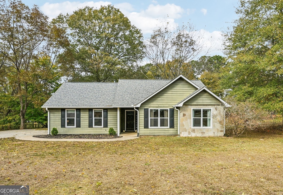
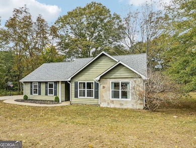
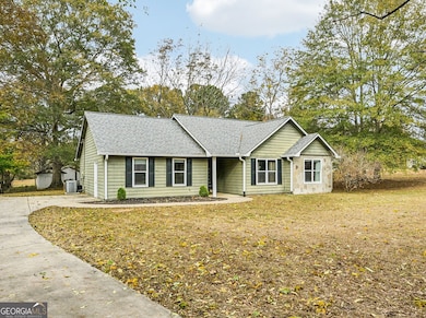
296 Mcintosh Trail Sharpsburg, GA 30277
Estimated payment $1,858/month
Highlights
- Seasonal View
- Vaulted Ceiling
- Partially Wooded Lot
- Willis Road Elementary School Rated A-
- Ranch Style House
- Bonus Room
About This Home
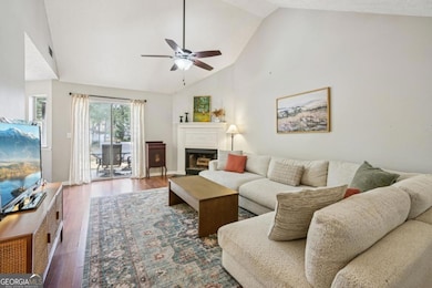
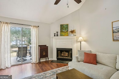
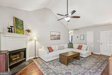
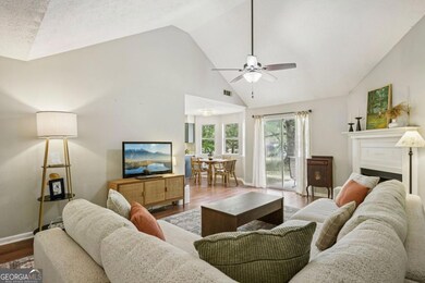
Charming 3-Bedroom Ranch with Bonus Flex Space! This cozy 3-bedroom, 2-bath ranch offers the perfect blend of comfort and convenience. Ideally located for privacy yet just minutes from schools, shopping, and restaurants. The adorable kitchen features a bright eating area overlooking the backyard and easy access to the laundry for everyday convenience. Enjoy the open layout connecting the kitchen to the living room, complete with a cozy gas fireplace, vaulted ceilings that create an open, airy feel, and sliding doors leading to a lovely patio-perfect for entertaining or relaxing outdoors. The spacious, level lot is enhanced by several charming birdhouses, a huge, beautiful tree that adds shade and character to the backyard, and an additional outbuilding for extra storage. A skylight in the primary bathroom brings in wonderful natural light, adding to the home's warm and inviting atmosphere. This home is perfect for first-time homebuyers, a growing family, or investors looking for a great rental opportunity. No HOA! Don't miss this great opportunity-schedule your showing today!
Home Details
Home Type
- Single Family
Est. Annual Taxes
- $2,110
Year Built
- Built in 1992
Lot Details
- 0.86 Acre Lot
- Level Lot
- Partially Wooded Lot
- Grass Covered Lot
Home Design
- Ranch Style House
- Traditional Architecture
- Slab Foundation
- Composition Roof
- Wood Siding
- Concrete Siding
- Stone Siding
- Stone
Interior Spaces
- 1,500 Sq Ft Home
- Vaulted Ceiling
- Ceiling Fan
- Factory Built Fireplace
- Family Room with Fireplace
- Home Office
- Bonus Room
- Seasonal Views
- Pull Down Stairs to Attic
- Laundry in Kitchen
Kitchen
- Breakfast Area or Nook
- Oven or Range
- Ice Maker
- Dishwasher
- Stainless Steel Appliances
Flooring
- Carpet
- Laminate
Bedrooms and Bathrooms
- 3 Main Level Bedrooms
- 2 Full Bathrooms
Parking
- 3 Parking Spaces
- Parking Pad
- Side or Rear Entrance to Parking
Outdoor Features
- Patio
Schools
- Willis Road Elementary School
- East Coweta Middle School
- East Coweta High School
Utilities
- Central Heating and Cooling System
- Heating System Uses Natural Gas
- Gas Water Heater
- Septic Tank
- Cable TV Available
Community Details
- No Home Owners Association
- Doe Run Subdivision
Listing and Financial Details
- Tax Lot A3
Map
Home Values in the Area
Average Home Value in this Area
Tax History
| Year | Tax Paid | Tax Assessment Tax Assessment Total Assessment is a certain percentage of the fair market value that is determined by local assessors to be the total taxable value of land and additions on the property. | Land | Improvement |
|---|---|---|---|---|
| 2025 | $2,147 | $95,828 | $24,000 | $71,828 |
| 2024 | $2,110 | $95,489 | $24,000 | $71,489 |
| 2023 | $2,110 | $97,332 | $18,000 | $79,332 |
| 2022 | $1,671 | $72,543 | $18,000 | $54,543 |
| 2021 | $1,378 | $57,027 | $18,000 | $39,027 |
| 2020 | $1,386 | $57,027 | $18,000 | $39,027 |
| 2019 | $1,209 | $46,110 | $10,000 | $36,110 |
| 2018 | $1,212 | $46,110 | $10,000 | $36,110 |
| 2017 | $1,212 | $46,110 | $10,000 | $36,110 |
| 2016 | $1,199 | $46,110 | $10,000 | $36,110 |
| 2015 | $1,017 | $40,332 | $10,000 | $30,332 |
| 2014 | $1,011 | $40,332 | $10,000 | $30,332 |
Property History
| Date | Event | Price | List to Sale | Price per Sq Ft |
|---|---|---|---|---|
| 11/12/2025 11/12/25 | For Sale | $319,000 | -- | $213 / Sq Ft |
Purchase History
| Date | Type | Sale Price | Title Company |
|---|---|---|---|
| Warranty Deed | $200,000 | -- | |
| Deed | $68,900 | -- | |
| Deed | $40,000 | -- | |
| Deed | $180,000 | -- |
Mortgage History
| Date | Status | Loan Amount | Loan Type |
|---|---|---|---|
| Open | $202,020 | New Conventional |
Source: Georgia MLS
MLS Number: 10642193
APN: 136-1122-011
Disclaimer: Certain information contained herein is derived from information provided by parties other than Homes.com. All information provided is deemed reliable, but is not guaranteed to be accurate and should be independently verified.
![]() The data relating to real estate for sale on this web site comes in part from the Broker Reciprocity Program of Georgia MLS. Real estate listings held by brokerage firms other than Redfin are marked with the Broker Reciprocity logo and detailed information about them includes the name of the listing brokers. Information deemed reliable but not guaranteed. Copyright 2025 Georgia MLS. All rights reserved.
The data relating to real estate for sale on this web site comes in part from the Broker Reciprocity Program of Georgia MLS. Real estate listings held by brokerage firms other than Redfin are marked with the Broker Reciprocity logo and detailed information about them includes the name of the listing brokers. Information deemed reliable but not guaranteed. Copyright 2025 Georgia MLS. All rights reserved.
- 28 Fawn Ct
- 193 Doe Run Ct
- 483 Mcintosh Trail
- Briarwood Plan at Twelve Parks 55+
- Sullivan Plan at Twelve Parks 55+
- 4 Unicoi Trail
- 12 Unicoi Trail
- Crestwood Plan at Twelve Parks 55+
- Brunswick Plan at Twelve Parks 55+
- 98 Keown Loop
- LOT 2 Mcintosh Trail Unit 2
- 0 Bob Smith Rd Unit 10562838
- 196 Bob Smith Rd
- 138 Main St
- 40 Long Branch Trail
- 8 Chiefs Trail
- 30 Shelley Ln
- 73 Oakhurst Trail
- 50 Kay Ct
- Grayson with Basement Plan at Twelve Parks - Ranch
- 45 Chemin Place
- 28 Sandstone Dr
- 140 Old Mill Way
- 10 McIntosh Estates Dr
- 15 Stonewood Way
- 60 Riverside Pkwy Unit 1
- 15 Candlewood Ct
- 42 Kentucky Ave
- 67 Kentucky Ave
- 41 St Charles Place
- 60 Vineyards Dr
- 162 Ashton Place
- 25 Elberta Dr
- 51 Bradford Station Dr
- 66 Cottage Dr
- 604 Tower Rd
- 102 Hickory Dr
- 350 Bee Rd
- 288 Turnbridge Cir
- 226 Turnbridge Cir
