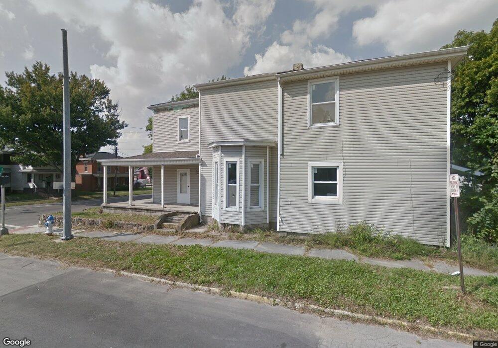
296 N State St Marion, OH 43302
Estimated Value: $129,000 - $188,000
3
Beds
1
Bath
2,637
Sq Ft
$58/Sq Ft
Est. Value
About This Home
This home is located at 296 N State St, Marion, OH 43302 and is currently estimated at $152,000, approximately $57 per square foot. 296 N State St is a home located in Marion County with nearby schools including William H. Taft Elementary School, Ulysses S. Grant Middle School, and Harding High School.
Ownership History
Date
Name
Owned For
Owner Type
Purchase Details
Closed on
Jun 12, 2019
Sold by
State Of Ohio
Bought by
Badertscher Patty
Current Estimated Value
Purchase Details
Closed on
Apr 9, 2019
Bought by
Marion County Auditor
Purchase Details
Closed on
Oct 26, 2005
Sold by
Devore Insurance Agency Ltd
Bought by
Devore Rentals Llc
Purchase Details
Closed on
Jun 29, 2005
Sold by
Swaney Robert and Swaney Lynn A
Bought by
Devore Insurance Agency Ltd
Home Financials for this Owner
Home Financials are based on the most recent Mortgage that was taken out on this home.
Original Mortgage
$32,000
Interest Rate
5.69%
Mortgage Type
Future Advance Clause Open End Mortgage
Purchase Details
Closed on
Jan 31, 2003
Bought by
Devore Rentals Llc
Purchase Details
Closed on
Jan 22, 2002
Bought by
Devore Rentals Llc
Create a Home Valuation Report for This Property
The Home Valuation Report is an in-depth analysis detailing your home's value as well as a comparison with similar homes in the area
Home Values in the Area
Average Home Value in this Area
Purchase History
| Date | Buyer | Sale Price | Title Company |
|---|---|---|---|
| Badertscher Patty | $850 | None Available | |
| Marion County Auditor | -- | -- | |
| Devore Rentals Llc | -- | None Available | |
| Devore Insurance Agency Ltd | $3,000 | Chicago Title | |
| Devore Rentals Llc | $25,000 | -- | |
| Devore Rentals Llc | -- | -- |
Source: Public Records
Mortgage History
| Date | Status | Borrower | Loan Amount |
|---|---|---|---|
| Previous Owner | Devore Insurance Agency Ltd | $32,000 |
Source: Public Records
Tax History
| Year | Tax Paid | Tax Assessment Tax Assessment Total Assessment is a certain percentage of the fair market value that is determined by local assessors to be the total taxable value of land and additions on the property. | Land | Improvement |
|---|---|---|---|---|
| 2025 | $1,605 | $57,070 | $1,730 | $55,340 |
| 2024 | $1,605 | $41,840 | $1,630 | $40,210 |
| 2023 | $1,605 | $41,840 | $1,630 | $40,210 |
| 2022 | $981 | $27,520 | $1,630 | $25,890 |
| 2021 | $647 | $16,320 | $1,410 | $14,910 |
| 2020 | $1,018 | $21,090 | $1,410 | $19,680 |
| 2019 | $0 | $21,090 | $1,410 | $19,680 |
| 2018 | $1,301 | $19,130 | $1,340 | $17,790 |
| 2017 | $1,969 | $19,130 | $1,340 | $17,790 |
| 2016 | $908 | $19,130 | $1,340 | $17,790 |
| 2015 | $903 | $18,810 | $1,340 | $17,470 |
| 2014 | $1,273 | $18,810 | $1,340 | $17,470 |
| 2012 | $928 | $19,080 | $2,130 | $16,950 |
Source: Public Records
Map
Nearby Homes
- 434 N State St
- 438 N Prospect St Unit 434
- 393 E George St
- 212 Short St
- 531 N Main St
- 532 N Prospect St
- 136 Baker St Unit 4
- 552 N Prospect St
- 343 Commercial St
- 279 E Fairground St
- 636 Oak St
- 324 W Church St
- 197 Harrison St
- 594 E George St
- 736 N Main St
- 229 W Columbia St
- 648 E George St
- 569 E Church St
- 372 S Main St
- 516 Polk St
- 302 N State St
- 306 N State St
- 247 S State St
- 182 E George St
- 284 N State St
- 295 N State St
- 188 E George St
- 320 N State St
- 305 N State St
- 191 E George St
- 191 E George St
- 196 E George St
- 328 N State St
- 268 N State St
- 199 E George St
- 334 N State St
- 262 N State St
- 329 N State St
- 201 E George St
- 204 E George St
Your Personal Tour Guide
Ask me questions while you tour the home.