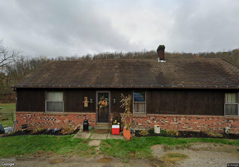
296 Roupe Rd Eighty Four, PA 15330
Estimated Value: $105,000 - $446,000
2
Beds
1
Bath
1,104
Sq Ft
$211/Sq Ft
Est. Value
About This Home
This home is located at 296 Roupe Rd, Eighty Four, PA 15330 and is currently estimated at $232,469, approximately $210 per square foot. 296 Roupe Rd is a home with nearby schools including Trinity Senior High School.
Ownership History
Date
Name
Owned For
Owner Type
Purchase Details
Closed on
Jan 4, 2019
Sold by
Bauer James F and Bauer Roberta L
Bought by
Smith Bernard W and Bauer Leann
Current Estimated Value
Home Financials for this Owner
Home Financials are based on the most recent Mortgage that was taken out on this home.
Original Mortgage
$88,310
Outstanding Balance
$77,955
Interest Rate
4.8%
Mortgage Type
Future Advance Clause Open End Mortgage
Estimated Equity
$154,515
Purchase Details
Closed on
Jun 27, 2011
Sold by
Colteryahn Keith D
Bought by
Bauer James
Create a Home Valuation Report for This Property
The Home Valuation Report is an in-depth analysis detailing your home's value as well as a comparison with similar homes in the area
Home Values in the Area
Average Home Value in this Area
Purchase History
| Date | Buyer | Sale Price | Title Company |
|---|---|---|---|
| Smith Bernard W | $85,000 | None Available | |
| Bauer James | $30,000 | -- |
Source: Public Records
Mortgage History
| Date | Status | Borrower | Loan Amount |
|---|---|---|---|
| Open | Smith Bernard W | $88,310 |
Source: Public Records
Tax History
| Year | Tax Paid | Tax Assessment Tax Assessment Total Assessment is a certain percentage of the fair market value that is determined by local assessors to be the total taxable value of land and additions on the property. | Land | Improvement |
|---|---|---|---|---|
| 2025 | $1,520 | $72,800 | $2,000 | $70,800 |
| 2024 | $1,311 | $72,800 | $2,000 | $70,800 |
| 2023 | $1,311 | $72,800 | $2,000 | $70,800 |
| 2022 | $1,269 | $72,800 | $2,000 | $70,800 |
| 2021 | $2,642 | $153,800 | $83,000 | $70,800 |
| 2020 | $2,642 | $153,800 | $83,000 | $70,800 |
| 2019 | $2,575 | $153,800 | $83,000 | $70,800 |
| 2018 | $2,619 | $153,800 | $83,000 | $70,800 |
| 2017 | $297 | $153,800 | $83,000 | $70,800 |
| 2016 | $297 | $11,932 | $4,680 | $7,252 |
| 2015 | -- | $11,932 | $4,680 | $7,252 |
| 2014 | $297 | $11,932 | $4,680 | $7,252 |
| 2013 | $297 | $11,932 | $4,680 | $7,252 |
Source: Public Records
Map
Nearby Homes
- 19 Old Monongahela Pike
- 190 Linnwood Rd
- 124 Dyersstone Dr
- 216 Kopper Kettle Rd
- Lot 355 & 356 Floral Hill Dr
- 338 Quarry Rd
- 1075 E National Pike
- 60 Carl Ave
- 4 Koa Rd
- 373 Lakeview Dr
- Bieda Lot Davis School Rd
- 49 Woodside Dr
- 0 Route 519 Unit 1728830
- 0 Route 519 Unit 1706095
- National Pike
- LOT 8 Thomas Eighty Four Rd
- 350 Cedar Dr
- 1645 Route 519
- 872 Pleasant Hill Dr
- 62 Lena Ln
Your Personal Tour Guide
Ask me questions while you tour the home.