Estimated Value: $342,000 - $393,000
3
Beds
1
Bath
1,200
Sq Ft
$306/Sq Ft
Est. Value
About This Home
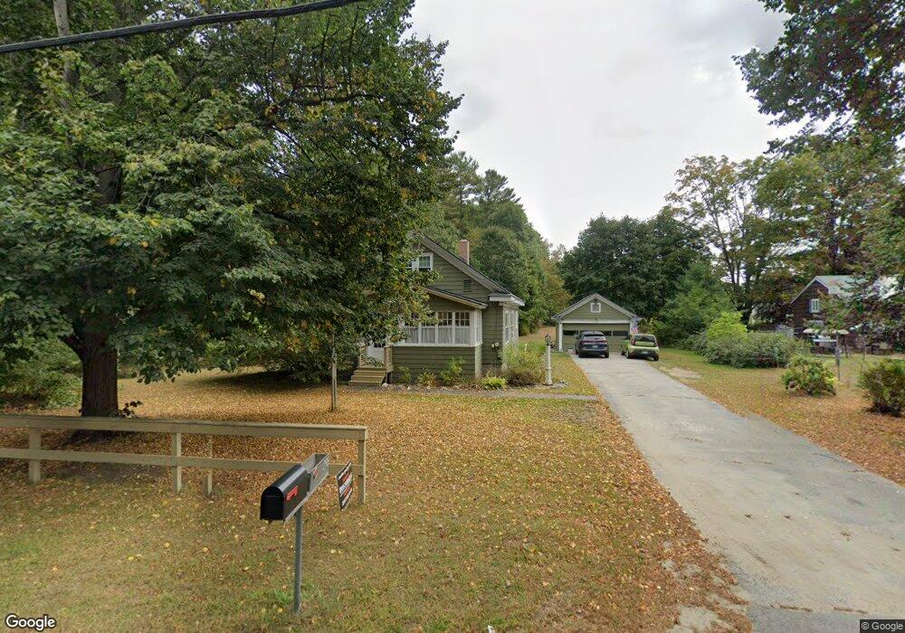
This home is located at 296 Shaker Rd, Gray, ME 04039 and is currently estimated at $367,354, approximately $306 per square foot. 296 Shaker Rd is a home located in Cumberland County with nearby schools including Gray-New Gloucester High School and Fiddlehead School of Arts & Science.
Ownership History
Date
Name
Owned For
Owner Type
Purchase Details
Closed on
May 1, 2020
Sold by
Pierce Linda M
Bought by
Lackey Robin M and Lackey Todd M
Current Estimated Value
Home Financials for this Owner
Home Financials are based on the most recent Mortgage that was taken out on this home.
Original Mortgage
$200,000
Outstanding Balance
$176,450
Interest Rate
3.3%
Mortgage Type
VA
Estimated Equity
$190,904
Purchase Details
Closed on
Aug 31, 2007
Sold by
Cormier Barbara
Bought by
Pierce Linda M
Home Financials for this Owner
Home Financials are based on the most recent Mortgage that was taken out on this home.
Original Mortgage
$166,500
Interest Rate
6.71%
Mortgage Type
Unknown
Create a Home Valuation Report for This Property
The Home Valuation Report is an in-depth analysis detailing your home's value as well as a comparison with similar homes in the area
Home Values in the Area
Average Home Value in this Area
Purchase History
| Date | Buyer | Sale Price | Title Company |
|---|---|---|---|
| Lackey Robin M | -- | None Available | |
| Lackey Robin M | -- | None Available | |
| Pierce Linda M | -- | -- | |
| Pierce Linda M | -- | -- |
Source: Public Records
Mortgage History
| Date | Status | Borrower | Loan Amount |
|---|---|---|---|
| Open | Lackey Robin M | $200,000 | |
| Closed | Lackey Robin M | $200,000 | |
| Previous Owner | Pierce Linda M | $166,500 |
Source: Public Records
Tax History
| Year | Tax Paid | Tax Assessment Tax Assessment Total Assessment is a certain percentage of the fair market value that is determined by local assessors to be the total taxable value of land and additions on the property. | Land | Improvement |
|---|---|---|---|---|
| 2025 | $3,091 | $319,300 | $115,500 | $203,800 |
| 2024 | $3,097 | $319,300 | $115,500 | $203,800 |
| 2023 | $3,223 | $212,300 | $65,400 | $146,900 |
| 2022 | $2,962 | $212,300 | $65,400 | $146,900 |
| 2021 | $2,840 | $194,400 | $65,400 | $129,000 |
| 2020 | $2,867 | $194,400 | $65,400 | $129,000 |
| 2019 | $2,867 | $194,400 | $65,400 | $129,000 |
| 2018 | $2,442 | $194,400 | $65,400 | $129,000 |
| 2017 | $1,816 | $113,600 | $30,000 | $83,600 |
| 2016 | $2,079 | $113,600 | $30,000 | $83,600 |
| 2015 | $2,038 | $112,000 | $30,000 | $82,000 |
| 2014 | $2,038 | $112,000 | $30,000 | $82,000 |
| 2012 | $1,775 | $111,988 | $30,000 | $81,988 |
Source: Public Records
Map
Nearby Homes
- 224 Shaker Rd
- 4 Chelsey Ln
- 65 Blueberry Ln
- Lot 21-29 Weymouth Rd
- 2 Ethan Way
- 3 First Mill Dr
- 86 Skips Way
- 270 Mayall Rd
- 17 Callaway Dr Unit 17
- 0 Mayall
- M011-006 Westwood Rd
- 52 Colley Hill Rd
- 0 Colley Hill Rd
- 13 Yarmouth Rd
- 14 Yarmouth Rd
- 25 Yarmouth Rd
- Lot 73A Vogel Rd
- 22 Woodcock Dr
- 60 Woodcock Dr
- 14 Golden Way
Your Personal Tour Guide
Ask me questions while you tour the home.