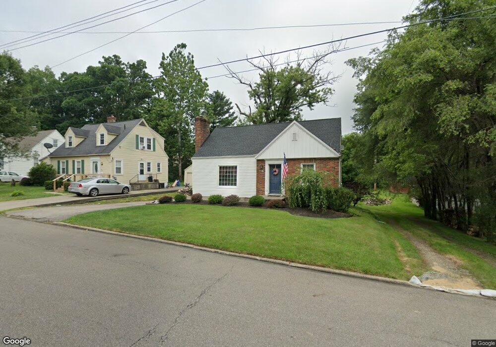
296 Taylor Rd Mansfield, OH 44903
Estimated Value: $143,163 - $154,000
3
Beds
2
Baths
1,239
Sq Ft
$122/Sq Ft
Est. Value
About This Home
This home is located at 296 Taylor Rd, Mansfield, OH 44903 and is currently estimated at $150,541, approximately $121 per square foot. 296 Taylor Rd is a home located in Richland County with nearby schools including Mansfield Elective Academy, Interactive Media & Construction (IMAC) Academy, and Discovery School.
Ownership History
Date
Name
Owned For
Owner Type
Purchase Details
Closed on
Sep 15, 2005
Sold by
Harper Roeliff E
Bought by
Engelke Paul H and Engelke Carrie L
Current Estimated Value
Home Financials for this Owner
Home Financials are based on the most recent Mortgage that was taken out on this home.
Original Mortgage
$62,000
Outstanding Balance
$30,204
Interest Rate
4.45%
Mortgage Type
Fannie Mae Freddie Mac
Estimated Equity
$120,337
Purchase Details
Closed on
Oct 10, 1991
Sold by
Ludwig Michael J
Bought by
Harper Roeliff E
Purchase Details
Closed on
Sep 24, 1990
Create a Home Valuation Report for This Property
The Home Valuation Report is an in-depth analysis detailing your home's value as well as a comparison with similar homes in the area
Home Values in the Area
Average Home Value in this Area
Purchase History
| Date | Buyer | Sale Price | Title Company |
|---|---|---|---|
| Engelke Paul H | $72,000 | Chicago Title | |
| Harper Roeliff E | $43,500 | -- | |
| -- | $40,000 | -- |
Source: Public Records
Mortgage History
| Date | Status | Borrower | Loan Amount |
|---|---|---|---|
| Open | Engelke Paul H | $62,000 |
Source: Public Records
Tax History Compared to Growth
Tax History
| Year | Tax Paid | Tax Assessment Tax Assessment Total Assessment is a certain percentage of the fair market value that is determined by local assessors to be the total taxable value of land and additions on the property. | Land | Improvement |
|---|---|---|---|---|
| 2024 | $1,527 | $32,620 | $4,370 | $28,250 |
| 2023 | $1,527 | $32,620 | $4,370 | $28,250 |
| 2022 | $1,313 | $23,490 | $3,750 | $19,740 |
| 2021 | $1,322 | $23,490 | $3,750 | $19,740 |
| 2020 | $1,351 | $23,490 | $3,750 | $19,740 |
| 2019 | $1,498 | $23,490 | $3,750 | $19,740 |
| 2018 | $1,477 | $23,490 | $3,750 | $19,740 |
| 2017 | $1,469 | $23,490 | $3,750 | $19,740 |
| 2016 | $1,501 | $23,790 | $4,850 | $18,940 |
| 2015 | $1,501 | $23,790 | $4,850 | $18,940 |
| 2014 | $1,415 | $23,790 | $4,850 | $18,940 |
| 2012 | $1,302 | $23,780 | $5,100 | $18,680 |
Source: Public Records
Map
Nearby Homes
- 679 Coleman Rd
- 191 Fairlawn Ave
- 212 Marlow Rd
- 408 Fairlawn Ave
- 143 Fairlawn Ave
- 135 Fairlawn Ave
- 129 Fairlawn Ave
- 190 S Linden Rd
- 616 Cline Ave
- 118 Parkwood Blvd
- 143 Kingwood Place
- 538 Broadview Ave
- 133 Stewart Ave S
- 244 S Trimble Rd Unit 246
- 232 S Trimble Rd Unit 234
- 78 Glenwood Blvd
- 216 S Trimble Rd Unit 218
- 126 Dawson Ave
- 41 Parkwood Blvd
- 37 S Linden Rd
- 302 Taylor Rd
- 000 Taylor Rd
- 747 Arlington Ave
- 297 Fairlawn Ave
- 305 Fairlawn Ave
- 306 Taylor Rd
- 765 Arlington Ave
- 745 Arlington Ave
- 309 Fairlawn Ave Unit 311
- 741 Arlington Ave
- 299 Taylor Rd
- 314 Taylor Rd
- 771 Arlington Ave
- 313 Fairlawn Ave Unit 315
- 309 Taylor Rd
- 320 Taylor Rd
- 315 Taylor Rd
- 775 Arlington Ave
- 324 Taylor Rd
- 321 Taylor Rd