Estimated Value: $205,692 - $271,000
3
Beds
2
Baths
1,439
Sq Ft
$173/Sq Ft
Est. Value
About This Home
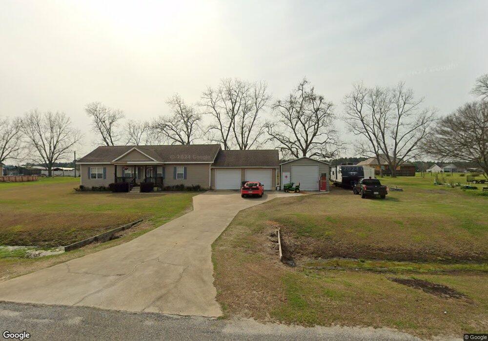
This home is located at 296 Virginia Cir, Cairo, GA 39828 and is currently estimated at $248,673, approximately $172 per square foot. 296 Virginia Cir is a home located in Grady County.
Ownership History
Date
Name
Owned For
Owner Type
Purchase Details
Closed on
May 4, 2023
Sold by
Meadows Wesley
Bought by
Meadows Wesley Charles and Meadows Virginia Carol
Current Estimated Value
Purchase Details
Closed on
Sep 19, 2005
Sold by
Brock Tony
Bought by
Meadows Wesley
Home Financials for this Owner
Home Financials are based on the most recent Mortgage that was taken out on this home.
Original Mortgage
$132,331
Interest Rate
5.77%
Mortgage Type
FHA
Purchase Details
Closed on
Dec 17, 2004
Sold by
M & S Properties
Bought by
Brock Tony
Create a Home Valuation Report for This Property
The Home Valuation Report is an in-depth analysis detailing your home's value as well as a comparison with similar homes in the area
Purchase History
| Date | Buyer | Sale Price | Title Company |
|---|---|---|---|
| Meadows Wesley Charles | -- | -- | |
| Meadows Wesley | $134,000 | -- | |
| Brock Tony | $22,000 | -- |
Source: Public Records
Mortgage History
| Date | Status | Borrower | Loan Amount |
|---|---|---|---|
| Previous Owner | Meadows Wesley | $132,331 |
Source: Public Records
Tax History Compared to Growth
Tax History
| Year | Tax Paid | Tax Assessment Tax Assessment Total Assessment is a certain percentage of the fair market value that is determined by local assessors to be the total taxable value of land and additions on the property. | Land | Improvement |
|---|---|---|---|---|
| 2024 | $1,586 | $66,881 | $4,424 | $62,457 |
| 2023 | $1,599 | $53,928 | $3,400 | $50,528 |
| 2022 | $1,599 | $53,928 | $3,400 | $50,528 |
| 2021 | $1,604 | $53,928 | $3,400 | $50,528 |
| 2020 | $1,609 | $53,928 | $3,400 | $50,528 |
| 2019 | $1,609 | $53,928 | $3,400 | $50,528 |
| 2018 | $1,511 | $53,928 | $3,400 | $50,528 |
| 2017 | $1,438 | $53,928 | $3,400 | $50,528 |
| 2016 | $1,460 | $54,416 | $12,000 | $42,416 |
| 2015 | $960 | $36,880 | $4,400 | $32,480 |
| 2014 | $961 | $36,880 | $4,400 | $32,480 |
| 2013 | -- | $41,756 | $4,400 | $37,356 |
Source: Public Records
Map
Nearby Homes
- 281 Virginia Cir
- 4164 U S 84 Unit Lot Q
- 129 Alison Dr
- 161 Evergreen Ln
- 3109 U S 84
- 3109 U S 84
- 88 Ruby Ln
- 0 NE Airport Rd Unit 145784
- 78.6 Ac Strickland Rd
- 2600 U S 84
- 2427 Pierce Chapel Rd
- 21 24th St NE
- 66 22nd St NE
- 00 Academy Dr
- 3136 State Route 188
- 0 20th St NE
- 00 20th St NE
- 592 20th St SE
- 408 Bay Tree Rd NE
- 0 State Route 188
- 310 Virginia Cir
- 282 Virginia Cir
- 184 Virginia Cir
- 156 Virginia Cir
- 295 Virginia Cir
- Lot 52 Virginia Cir
- Lot 18 Virginia Cir Unit 18
- Lot 23 Virginia Cir Unit 23
- Lot 21 Virginia Cir Unit 21
- Lot 17 Virginia Cir Unit 17
- Lot 20 Virginia Cir Unit 20
- Lot 31 Virginia Cir Unit 31
- 142 Virginia Cir
- 268 Virginia Cir
- 324 Virginia Cir
- 198 Virginia Cir
- 175 Virginia Cir
- 323 Virginia Cir
- 161 Virginia Cir
- 104 Poplar Ln