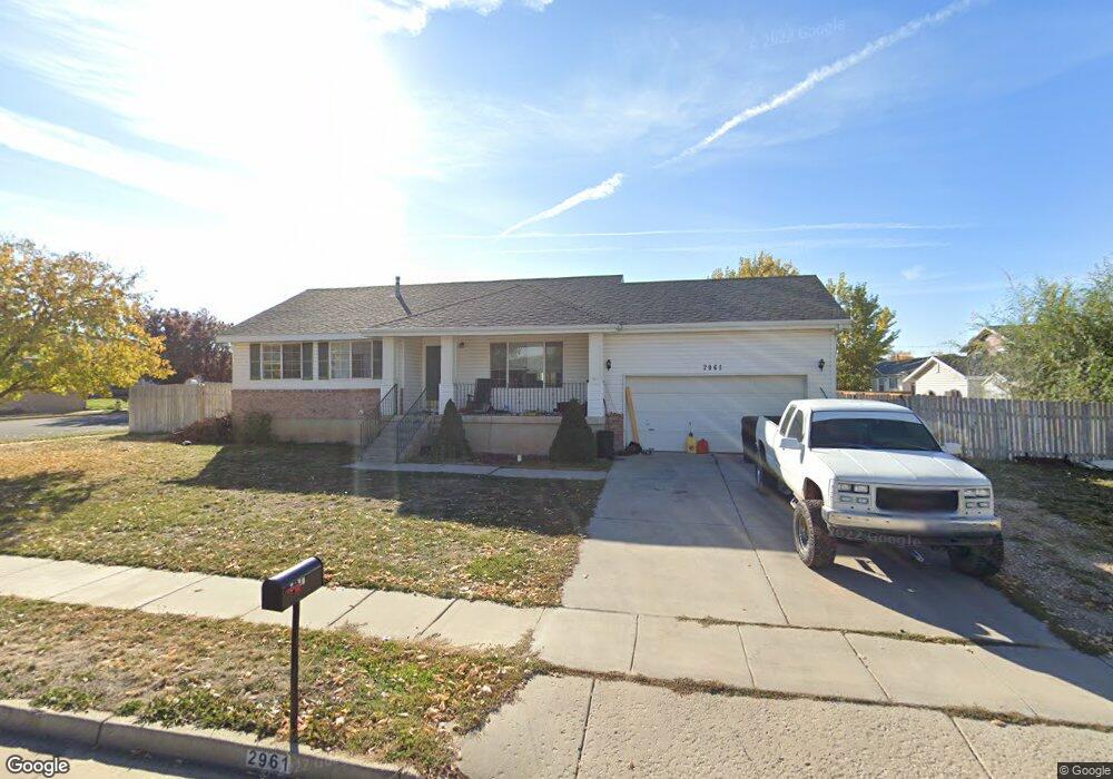
2961 W 1400 N Clearfield, UT 84015
Estimated Value: $431,000 - $457,000
4
Beds
2
Baths
2,070
Sq Ft
$214/Sq Ft
Est. Value
About This Home
This home is located at 2961 W 1400 N, Clearfield, UT 84015 and is currently estimated at $443,726, approximately $214 per square foot. 2961 W 1400 N is a home located in Davis County with nearby schools including West Clinton Elementary School, West Point Junior High School, and Syracuse High School.
Ownership History
Date
Name
Owned For
Owner Type
Purchase Details
Closed on
Oct 10, 2017
Sold by
Cederlof Clayton B and Cederlof Alicia
Bought by
Ah4r Properties Llc
Current Estimated Value
Purchase Details
Closed on
Feb 17, 2006
Sold by
Cederlof Clayton B and Cederlof Alicia
Bought by
Cederlof Clayton B and Cederlof Alicia
Home Financials for this Owner
Home Financials are based on the most recent Mortgage that was taken out on this home.
Original Mortgage
$125,700
Interest Rate
6.04%
Mortgage Type
Fannie Mae Freddie Mac
Purchase Details
Closed on
Oct 15, 2003
Sold by
Cederlof Clayton B
Bought by
Cederlof Clayton B and Cederlof Alicia
Home Financials for this Owner
Home Financials are based on the most recent Mortgage that was taken out on this home.
Original Mortgage
$125,000
Interest Rate
6.4%
Mortgage Type
Purchase Money Mortgage
Purchase Details
Closed on
Jun 26, 2002
Sold by
Cederlof Clayton B
Bought by
Cederlof Clayton B and Alicia Maria
Purchase Details
Closed on
Jun 20, 2002
Sold by
Poike O Heinz
Bought by
Cloward Jerry E and Cloward Ute
Purchase Details
Closed on
Aug 30, 1996
Sold by
Prp Development Co
Bought by
Cloward Jerry E and Cloward Ute
Home Financials for this Owner
Home Financials are based on the most recent Mortgage that was taken out on this home.
Original Mortgage
$105,010
Interest Rate
8.2%
Mortgage Type
FHA
Purchase Details
Closed on
Apr 24, 1996
Sold by
Premier Homes Lc
Bought by
Bischoff Casey R and Bischoff Amy L
Home Financials for this Owner
Home Financials are based on the most recent Mortgage that was taken out on this home.
Original Mortgage
$85,270
Interest Rate
7.84%
Purchase Details
Closed on
Apr 16, 1996
Sold by
Bischoff Casey R and Bischoff Amy L
Bought by
Prp Development Co
Home Financials for this Owner
Home Financials are based on the most recent Mortgage that was taken out on this home.
Original Mortgage
$85,270
Interest Rate
7.84%
Create a Home Valuation Report for This Property
The Home Valuation Report is an in-depth analysis detailing your home's value as well as a comparison with similar homes in the area
Home Values in the Area
Average Home Value in this Area
Purchase History
| Date | Buyer | Sale Price | Title Company |
|---|---|---|---|
| Ah4r Properties Llc | -- | -- | |
| Cederlof Clayton B | -- | Backman Title Services | |
| Cederlof Clayton B | -- | Security Title Company | |
| Cederlof Clayton B | -- | Security Title Company | |
| Cederlof Clayton B | $136,900 | Associated Title Company | |
| Cederlof Clayton B | -- | Associated Title Company | |
| Cloward Jerry E | -- | Associated Title Company | |
| Cloward Jerry E | -- | Equity Title Agency | |
| Bischoff Casey R | -- | Equity Title | |
| Prp Development Co | -- | Equity Title Agency |
Source: Public Records
Mortgage History
| Date | Status | Borrower | Loan Amount |
|---|---|---|---|
| Previous Owner | Cederlof Clayton B | $125,700 | |
| Previous Owner | Cederlof Clayton B | $125,000 | |
| Previous Owner | Cloward Jerry E | $105,010 | |
| Previous Owner | Bischoff Casey R | $85,270 |
Source: Public Records
Tax History Compared to Growth
Tax History
| Year | Tax Paid | Tax Assessment Tax Assessment Total Assessment is a certain percentage of the fair market value that is determined by local assessors to be the total taxable value of land and additions on the property. | Land | Improvement |
|---|---|---|---|---|
| 2025 | $2,299 | $221,100 | $85,976 | $135,124 |
| 2024 | $2,282 | $220,549 | $94,491 | $126,058 |
| 2023 | $2,007 | $197,450 | $59,142 | $138,307 |
| 2022 | $2,157 | $388,000 | $119,543 | $268,457 |
| 2021 | $2,064 | $303,000 | $82,358 | $220,642 |
| 2020 | $1,797 | $261,000 | $70,005 | $190,995 |
| 2019 | $1,748 | $248,000 | $81,761 | $166,239 |
| 2018 | $1,607 | $224,000 | $69,052 | $154,948 |
| 2016 | $1,418 | $102,080 | $26,894 | $75,186 |
| 2015 | $1,372 | $93,940 | $26,894 | $67,046 |
| 2014 | $1,318 | $91,609 | $26,894 | $64,715 |
| 2013 | -- | $93,604 | $27,143 | $66,461 |
Source: Public Records
Map
Nearby Homes
- 2921 W 1300 N
- 3168 W 1300 N
- 2642 W 1500 N
- 3941 W 1800 N
- 2816 W 960 N
- 1251 N 2525 W
- 1449 N 2475 W
- 1509 N 2475 W
- 3648 W 900 N Unit 207
- 2371 W 1300 N
- 1458 N 2400 W
- 1958 N 2750 W
- 878 N 2600 W
- 2413 N Eurasian Crane Rd
- 2617 N 2080 W Unit 176
- 3656 W 1800 N
- 2259 W 1800 N
- 3212 W 600 N
- 1694 N 2225 W
- 2148 W 1570 N
- 1371 N 2950 W
- 1371 N 2950 W Unit 23
- 2983 W 1400 N
- 1372 N 3000 W
- 1359 N 2950 W
- 1359 N 2950 W Unit 24
- 2954 W 1400 N
- 2972 W 1400 N
- 1376 N 2950 W
- 2986 W 1400 N
- 2929 W 1400 N
- 1412 N 3000 W
- 1352 N 3000 W
- 1354 N 2950 W
- 1354 N 2950 W Unit 28
- 1343 N 2950 W
- 1432 N 3000 W
- 2924 W 1400 N
- 1338 N 2950 W
- 2907 W 1400 N